Crisis mapping for disaster preparedness is nothing new. In 2004, my colleague Suha Ulgen spearheaded an innovative project in Istanbul that combined public participation and mobile geospatial technologies for the purposes of disaster mitigation. Suha subsequently published an excellent overview of the project entitled “Public Participation Geographic Information Sharing Systems for Co-mmunity Based Urban Disaster Mitigation,” available in this edited book on Geo-Information for Disaster Management. I have referred to this project in count-less conversations since 2007 so it is high time I blog about it as well.
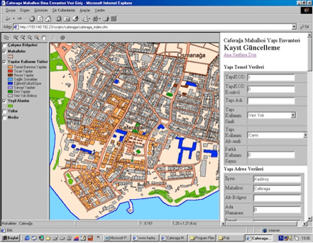
Suha’s project included a novel “Neighborhood Geographic Information Sharing System,” which “provided volunteers with skills and tools for identification of seismic risks and response assets in their neighborhoods. Field data collection volunteers used low-cost hand-held computers and data compiled was fed into a geospatial database accessible over the Internet. Interactive thematic maps enabled discussion of mitigation measures and action alternatives. This pilot evolved into a proposal for sustained implementation with local fire stations.” Below is a screenshot of the web-based system that enabled data entry and query.
There’s no reason why a similar approach could not be taken today, one that uses a dedicated smart phone app combined with integrated gamification and social networking features. The idea would be to make community mapping fun and rewarding; a way to foster a more active and connected community—which would in turn build more social capital. In the event of a disaster, this same smart phone app would allow users to simply “check in” to receive information on the nearest shelter areas (response assets) as well as danger zones such as overpasses, etc. This is why geo-fencing is so important for crisis mapping.
(Incidentally, Suha’s project also included a “School Commute Contingency Pilot” designed to track school-bus routes in Istanbul and thus “stimulate contingency planning for commute-time emergencies when 400,000 students travel an average of 45 minutes each way on 20,000 service buses. [GPS] data loggers were used to determine service bus routes displayed on printed maps high-lighting nearest schools along the route.” Suha proposed that “bus-drivers, parents and school managers be issued route maps with nearest schools that could serve as both meeting places and shelters”).
Fast forward to 2012 and the Humanitarian OpenStreetMap’s (HOT) novel project “Community Mapping for Exposure in Indonesia,” which resulted in the mapping of over 160,000 buildings and numerous village level maps in under ten months. The team also organized a university competition to create incentives for the mapping of urban areas. “The students were not only tasked to digitize buildings, but to also collect building information such building structure, wall type, roof type and the number of floors.” This contributed to the mapping and codification of some 30,000 buildings.
As Suha rightly noted almost 10 years ago, “for disaster mitigation measures to be effective they need to be developed in recognition of the local differences and adopted by the active participation of each community.” OSM’s work in Indonesia fully embodies the importance of mapping local differences and provides important insights on how to catalyze community participation. The buildup of social capital is another important outcome of these efforts. Social capital facilitates collective action and increases local capacity for self-organization, resulting in greater social resilience. In sum, these novel projects demonstrate that technologies used for crisis mapping can be used for disaster preparedness, mitigation and resilience.


Hi Patrick, have you also or know anyone who has looked at “Crisis Mapping for Genocide Prevention?”
Hi Henry, yes, perhaps something like this?
http://iRevolution.net/2011/03/18/live-crisis-maps-prevent-mass-atrocities
The use of “remote sensing” in disaster mapping (and preparedness) was initiated from baloons after the San Fransisco fire of the 19th century. And this was the start of using “remote sensing” in the Army first (WW I and WW II) and developed the first “remote sensing” programs in major universities, such as Purdue and Cornell (professors D.J. Beltcher, R. E. Frost, Merle Parvis, Donald Lueder, Ta Liang etc., etc.). Today there are several centers for remote sensing, primarily associated with academia. I would personally suggest the pooling of all these international resources under an international UN-affiliated program
Many thanks for the fascinating historical references, Leonidas!
Thanks for sharing, your post helped a lot and pointed me in the right direction. I am researching the topic and I am looking for existing research (to learn from) on the use of crisis maps specifically to prevent genocide, the question I’m trying to answer or at least gain more insight into being, “Will it work?” I’ll share my thoughts here http://humansecurityavenue.tumblr.com/
Pingback: Imagination For People's BLOG - Some mapping links
Pingback: Imagination For People's BLOG - Some mapping links
Pingback: Innovafrica's BLOG - Some mapping links