

I had the honor of spearheading this disaster recovery UAV mission in Nepal a few weeks ago as part of Kathmandu Flying Labs. I’ve been working on this new initiative (in my own time) with Kathmandu Living Labs (KLL), Kathmandu University (KU), DJI and Pix4D. This Flying Lab is the first of several local UAV innovation labs that I am setting up (in my personal capacity and during my holiday time) with friends and colleagues in disaster-prone countries around the world. The short film documentary above was launched just minutes ago by DJI and describes how we teamed up with local partners in Kathmandu to make use of aerial robotics (UAVs) to map Nepal’s recovery efforts.
Here are some of the 3D results, courtesy of Pix4D (click to enlarge):


Why work in 3D? Because disaster damage is a 3D phenomenon. This newfound ability to work in 3D has important implications for Digital Humanitarians. To be sure, the analysis of these 3D models could potentially be crowdsourced and eventually analyzed entirely within a Virtual Reality environment.
Since most of our local partners in Nepal don’t have easy access to computers or VR headsets, I found another way to unlock and liberate this digital data by printing our high-resolution maps on large, rollable banners.

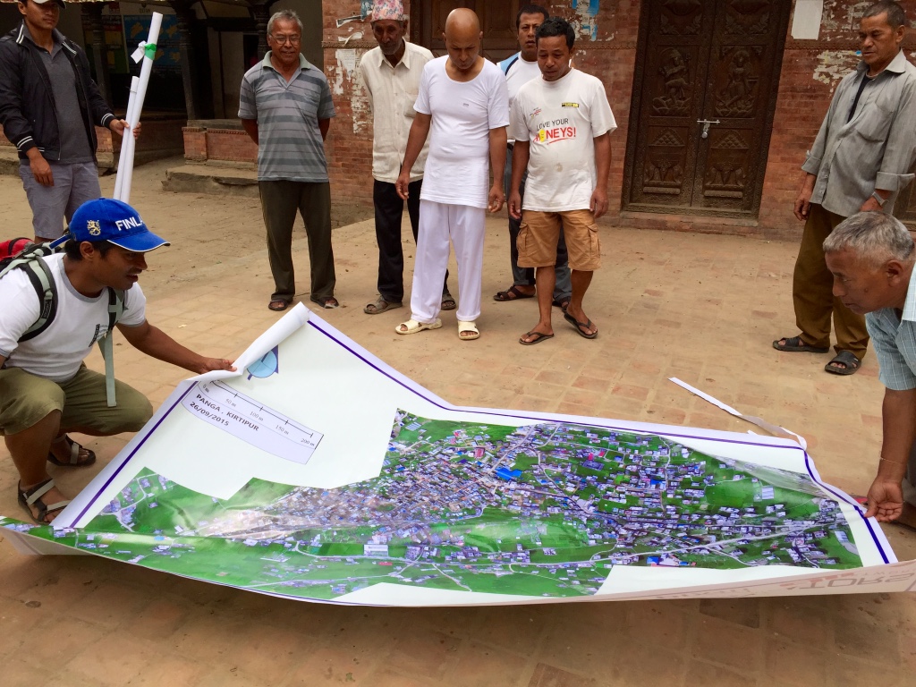
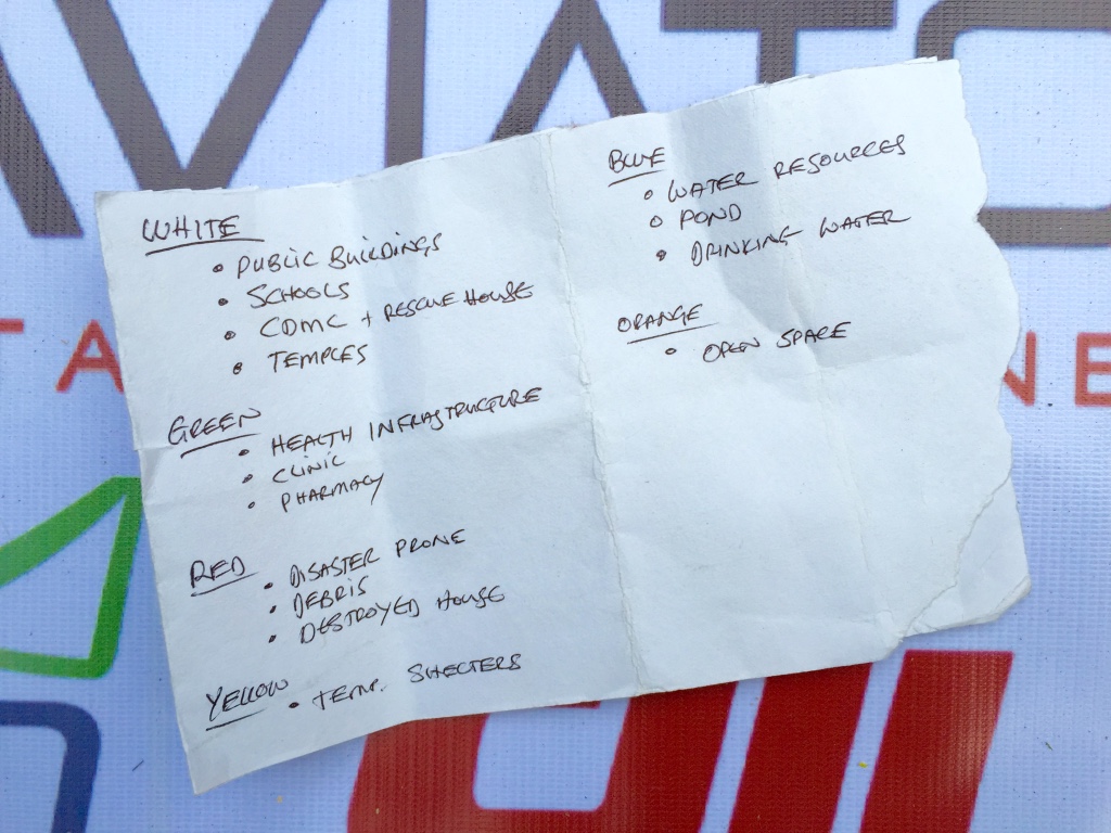
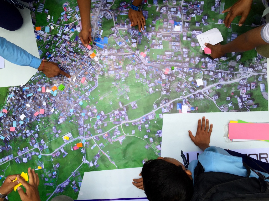
We brought these banner maps back to the local community and invited them to hack the map. How? Directly, by physically adding their local knowledge to the map; knowledge about the location of debris, temporary shelters, drinking water and lots more. We brought tape and color-coded paper with us to code this knowledge so that the community could annotate the map themselves.
In other words, we crowdsourced a crisis map of Panga, which was highly participatory. The result was a rich, contextual social layer on top of the base map, which further inform community discussions on strategies and priorities guiding their recovery efforts. For the first time ever, the community of Panga was working off the one and same dataset to inform their rebuilding. In short, our humanitarian mission combined aerial robotics, computer vision, water-proof banners, local knowledge, tape, paper and crowdsourcing to engage local communities on the reconstruction process.
I’m now spending my evenings & weekends working with friends and colleagues to plan a follow-up mission in early 2016. We’ll be returning to Kathmandu Flying Labs with new technology partners to train our local partners on how to use fixed-wing UAVs for large scale mapping efforts. In the meantime, we’re also exploring the possibility of co-creating Jakarta Flying Labs, Monrovia Flying Labs and Santiago Flying Labs in 2016.
I’m quitting my day job next week to devote myself full time to these efforts. Fact is, I’ve been using all of my free time (meaning evenings, weekends and many, many weeks of holiday time) to pursue my passion in aid robotics and to carry out volunteer-based UAV missions like the one in Nepal. I’ve also used holiday time (and my own savings) to travel across the globe to present this volunteer-work at high-profile events, such as the 2015 Web Summit here in Dublin where the DJI film documentary was just publicly launched.

My Nepali friends & I need your help to make sure that Kathmandu Flying Labs take-off and become a thriving and sustainable center of social entrepreneur-ship. To this end, we’re actively looking for both partners and sponsors to make all this happen, so please do get in touch if you share our vision. And if you’d like to learn more about how UAVs & other emerging technologies are changing the face of humanitarian action, then check out my new book Digital Humanitarians.
In the meantime, big, big thanks to our Nepali partners and technology partners for making our good work in Kathmandu possible!

Pingback: Patrick Meier posted a blog post… | Drones News Magazine
Pingback: Video: Crisis Mapping Nepal with UAVs - dronespain.es
Pingback: Video clip: Crisis Mapping Nepal with UAVs... - : ZeroDrift Drones, UAV, sUAS
Patrick and all,
Thank your for your work in bringing this amazing technology to a community in crisis and empowering them to move forward in their recovery!! Would you please post specification of the system you used in data gathering and processing – UAVs, camera, software for data processing, etc. Also is there a page on the Crisis Mappers Network where others can share this type of information – what systems work and specific information about configurations, processing, etc.
many thanks,
Lorene Yokoyama Becker
Thanks Lorene, all the info is in the blog post, we used the Phantom 3 (which comes with camera) and used Pix4D for processing. More info on UAVs and software platforms at UAViators.org
Keep the good work up Dr. Meier. More power to you and your team.
THis is fantastic. I hope more students in Nepal can have access to this equipment and tuition. It will give them a chance to help their country.
Stunning work. Thumbs up and huge support.
Awesome work you guys are doing. Came upon this as a course reading for my digital communities subject, just think it’s the best possible aspect of the digital revolution. All the best for the project.
Pingback: This is What Happens When Robotics Solutions Are Accessible to Local Partners in Nepal | iRevolutions
Pingback: This is How Nepalis are Using Drones for Humanitarian & Environmental Projects - dronespain.es
Pingback: This is How Nepalis are Using Drones for Humanitarian & Environmental Projects - Quadcopter Blog
Pingback: This is How Nepalis are Using Drones for Humanitarian & Environmental Projects - Drone LobbyistDrone Lobbyist
Pingback: This is How Nepalis are Using Drones for Humanitarian & Environmental Projects – Movenergy
Pingback: This is How Nepalis are Using Drones for Humanitarian & Environmental Projects - Drone Academy Thailand