
GeoFeedia was not originally designed to support humanitarian operations. But last year’s blog post on the potential of GeoFeedia for crisis mapping caught the interest of CEO Phil Harris. So he kindly granted the Standby Volunteer Task Force (SBTF) free access to the platform. In return, we provided his team with feedback on what features (listed here) would make GeoFeedia more useful for digital disaster response. This was back in summer 2012. I recently learned that they’ve been quite busy since. Indeed, I had the distinct pleasure of sharing the stage with Phil and his team at this superb conference on social media for emergency management. After listening to their talk, I realized it was high time to publish an update on GeoFeedia, especially since we had used the tool just two months earlier in response to Typhoon Pablo, one of the worst disasters to hit the Philippines in the past 100 years.
The 1-minute video is well worth watching if you’re new to GeoFeedia. The plat-form enables hyper local searches for information by location across multiple social media channels such as Twitter, Youtube, Flickr, Picasa & now Instagram. One of my favorite GeoFeedia features is the awesome geofeed (digital fence), which you can learn more about here. So what’s new besides Instagram? Well, the first suggestion I made last year was to provide users with the option of searching by both location and topic, rather than just location alone. And presto, this now possible, which means that digital humanitarians today can zoom into a disaster-affected area and filter by social media type, date and hashtag. This makes the geofeed feature even more compelling for crisis response, especially since geofeeds can also be saved and shared.
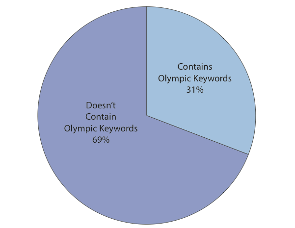
The vast majority of social media monitoring tools out there first filter by key-word and hashtag. Only later do they add location. As Phil points out, this mean they easily miss 70% of hyper local social media reports. Most users and org-anizations, who pay hefty licensing fees to uses these platforms, are typically unaware of this. The fact that GeoFeedia first filters by location is not an accident. This recent study (PDF) of the 2012 London Olympics showed that social media users posted close to 170,000 geo-tagged to Twitter, Instagram, Flickr, Picasa and YouTube during the games. But only 31% of these geo-tagged posts contained any Olympic-specific keywords and/or hashtags! So they decided to analyze another large event and again found the number of results drop by about 70% when not first filtering by location. Phil argues that people in a crisis situation obviously don’t wait for keywords or hashtags to form; so he expects this drop to happen for disasters as well. “Traditional keyword and hashtag search thus be complemented with a geo-graphical search in order to provide a full picture of social media content that is contextually relevant to an event.”
One of my other main recommendations to Phil & team last year had to do with analytics. There is a strong need for an “Analytics function that produces summary statistics and trends analysis for a geofeed of interest. This is where Geofeedia could better capture temporal dynamics by including charts, graphs and simple time-series analysis to depict how events have been unfolding over the past hour vs 12 hours, 24 hours, etc.” Well sure enough, one of GeoFeedia’s major new features is a GeoAnalytics Dashboard; an interface that enables users to discover temporal trends and patterns in social media—and to do so by geofeed. This means a user can now draw a geofeed around a specific area of interest in a given disaster zone and search for pictures that capture major infrastructure damage on a specified date that contain tags or descriptions with the words “#earthquake”, “damage,” “buildings,” etc. As Phil rightly points out, this provides a “huge time advantage during a crisis to give a yet another filtered layer of intelligence; in effect, social media that is highly relevant and actionable ‘bubbling-up to the top’ of the pile.”
I truly am a huge fan of the GeoFeedia platform. Plus, Phil & team have been very responsive to our interests in using their tool for disaster response. So I’m ex-cited to see which features they build out next. They’ve already got a “data portability” functionality that enables data export. Users can also publish content from GeoFeedia directly to their own social networks. Moreover, the filtered content produced by geofeeds can also be shared with individual who do not have a GeoFeedia account. In any event, I hope the team will take into account two items from my earlier wish list—namely Sentiment Analysis and GeoAlerts.
A Sentiment Analysis feature would capture the general mood and sentiment expressed hyper-locally within a defined geofeed in real-time. The automated Geo-Alerts feature would make the geofeed king. A GeoAlerts functionality would enable users to trigger specific actions based on different kinds of social media traffic within a given geofeed of interest. For example, I’d like to be notified if the number of pictures posted within my geofeed that are tagged with the words “#earthquake” and “damage,” increases by more than 20% in any given hour. Similarly, one could set a geofeed’s GeoAlert for a 10% increase in the number of tweets with the words “cholera” and “diarrhea” (these need not be in English, by the way) in any given 10-minute period. Users would then receive GeoAlerts via automated emails, Tweets and/or SMS’s. This feature would in effect make the GeoFeedia more of a mobile and “hands free” platform, like Waze for example.
My first blog post on GeoFeedia was entitled “GeoFeedia: Next Generation Crisis Mapping Technology?” The answer today is a definite “Yes!” While the platform was not originally designed with disaster response in mind, the team has since been adding important features that make the tool increasingly useful for humanitarian applications. And GeoFeedia has plans for more exciting develop-ments in 2013. Their commitment to innovation and strong continued interest in supporting digital disaster response is why I’m hoping to work more closely with them in the years to come. For example, our AIDR (Artificial Intelligence for Disaster Response) platform would really add a strong Machine Learning com-ponent to GeoFeedia’s search function, in effect enabling the tool to go beyond simple keyword search.


Thanks for posting this update Patrick. It is also exciting that Geofeedia is exploring GIS integration, so social media data can be incorporated into GIS analysis to explore complex relationships and guide decision making. I would also like to see a features to help identify key influencers by geographic location, and search against a defined list of social media profiles to assist staff tracking in emergencies.
Reblogged this on buridansblog and commented:
It is also exciting that Geofeedia is exploring GIS integration, so social media data can be incorporated into GIS analysis to explore complex relationships and guide decision making. I would also like to see a features to help identify key influencers by geographic location, and search against a defined list of social media profiles to assist staff tracking in emergencies.
Patrick – fascinating post, and was wondering – could this tool be used to help aggregate (and then cross-compare) social media reports of specific incidents in, say, Syria? For instance, what if a report surfaces on twitter of a summary execution of civilians at a specific place and time. Could you then use Geofeedia to see if there are any other reports that might reference that same event, and help corroborate the initial report?
Hi Michael – Yes, Geofeedia can be used to identify similar reports of the same event in an area. If a major event happens, then we will see many posts from a variety of individuals located in that geographic area. If not, a Geofeedia user should be mindful that an individual post could be false. For example, in NYC there was a shooting near the Empire State Building last August where dozens of individuals had posted images, Tweets and videos within minutes of the event. A Geofeedia user could tell instantaneously that this was a real event. In contrast, we heard a rumor that the New York Stock Exchange had flooded. We did locate one image and one Tweet. We deemed these posts to be fakes – if the Stock Exchange had flooded then certainly more citizen journalists would have posted via social media on this event……..
Phil,
Many thanks,
Michael
Geofeedia certainly is impressive, however I have two critical comments to make: First, their argument about missing important information (~70% of social media not using location/even specific hashtags) is exaggerated, because these social media posts might contain largely irrelevant information. I argue that if the posts would be about the event or the area, then users would have tagged them accordingly, because users want their posts to be read. The study does not show what those 70% of social media were actually about. Geofeedia thus mainly helps to capture what is going on in a geographic area, which is of course extremely useful for some applications. Second, they only use geo-tagged social media. Currently, only a very percentage of social media is geo-tagged. Further, the geo-tagging is often dubious, and it is uncertain whether it refers to the place the social is from or the place it is about. I would argue that by going for geo-tagged social media first, you actually miss more information than when doing it the other way round. (Disclaimer: We’ve been doing it the other way round, so I am clearly biased 😉 https://sites.google.com/site/geoconavi/).
Hi Frank: Our analysis compared Geofeedia data sets to traditional social media listening tools such as Radian6, Brandwatch, Sysemos, etc. Geofeedia is not a replacement for these tools nor your important work at GeoCONAVI. Geofeedia is meant to complement them. A crisis happens at a location, and through our algorithms a Geofeedia user can quickly search what’s happening at a place – anywhere in the world – real-time to perform situational awareness. To eliminate noise in the data stream, a Geofeedia can further filter by keyword, username, date range, data source, etc. Geo-tagged data is on the rise: last summer Instagram reported that upwards of 20% of their posts were geo-tagged and we’ve definitely seen an increase since then. With the worldwide transition from feature phones to smartphones, we expect this trend to only continue.
Hi Phil, thanks for sharing this information! To our own suprise, we haven’t seen a significant increase in geotagged tweets or flickr images in 2010-2012, although we certainly share your view that it will increase due to better implementation of GPS receivers in smartphones. I understand that your run a business and have patents pending, but are there any white papers or journal publications on how Geofeedia processes geo-tagged social media in real-time? We have shifted our research towards data capture with mobile wireless sensor networks, but Geofeedia seems to be an advanced tool that can do a lot of things we didn’t have resources to attempt, so I’m very curious. Cheers!
Patrick I enjoyed this post and I am looking forward to a demonstration of the tool soon. I have a question about your desire for a Sentiment Analysis trending tool however.
Given that Sentiment Analysis seems to me to be much more art than science how do you ascribe relative value to it in terms of other more scientifically rooted data analytics? Also, if the purpose of data mining is to develop actionable intelligence, what kind of weighting factor is assigned to something subject to emotional volatility when you have scarce resources. Dispatching and applying those resources based on a perceived mood as opposed to a quantifiable and demonstrable need seems potentially ripe for error.
I understand Sentiment Analysis is just one of the building blocks but it would seem to me you could still have a very solid foundation without it.
Pingback: GeoFeedia: Ready for Digital Disaster Response | usDART
Pingback: GDACSmobile: Disaster Responders Turn to Bounded Crowdsourcing | iRevolution
Pingback: Cyberculture roundup: Amazon buys my fav. Goodreads, Google’s patent move, “It’s Not Slacktivism if it Changes Culture”, Attack on Spamhaus… | Erkan's Field Diary
Pingback: Data Protection Protocols for Crisis Mapping | iRevolution
Pingback: #SMEM Crisis Response – The #bostonmarathon Bombing | buridansblog
I have been a member of Geofeedia for a few months now. I get periodic emails from them pointing me to major news events from everything to riots to gay marriage local news zones as well as worldwide breaking news.
I couldn’t help but notice their emails nudging me to investigate were dead silent when the Boston Marathon bombings took place. Interesting to ponder at least.
Pingback: Using Twitter to Map Blackouts During Hurricane Sandy | iRevolution