
Journalists and citizen journalists are already using small UAVs during disasters. And some are also posting their aerial videos online: Typhoon Haiyan (Yolanda), Moore Tornado, Arkansas Tornado and recent floods in Florida, for example. Like social media, this new medium—user-generated (aerial) content—can be used by humanitarian organizations to augment their damage assessments and situational awareness. I’m therefore spearheading the development of a crisis map to crowdsource the collection of aerial footage during disasters. This new “Humanitarian UAV Map” (HUM) project is linked to the Humanitarian UAV Network (UAViators).

The UAV Map, which will go live shortly, is inspired by Travel by Drone Map displayed above. In other words, we’re aiming for simplicity. Unlike the above map, however, we’ll be using OpenStreetMap (OSM) instead of Google Maps as our base map since the former is open source. What’s more, and as noted in my forthcoming book, the Humanitarian OSM Team (HOT) does outstanding work crowdsourcing up-to-date maps during disasters. So having OSM as a base map makes perfect sense.
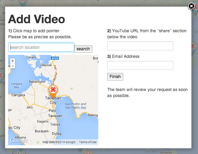
Given that we’ve already developed a VideoClicker as part of our MicroMappers platform, we’ll be using said Clicker to crowdsource the analysis & quality control of videos posted to our crisis map. Stay tuned for the launch, our Crisis Aerial Map will be live shortly.

See Also:
- Welcome to the Humanitarian UAV Network [link]
- How UAVs are Making a Difference in Disaster Response [link]
- Humanitarians Using UAVs for Post Disaster Recovery [link]
- Grassroots UAVs for Disaster Response [link]
- Using UAVs for Search & Rescue [link]
- Debrief: UAV/Drone Search & Rescue Challenge [link]
- Crowdsourcing Analysis of UAV Imagery for Search/Rescue [link]
- Check-List for Flying UAVs in Humanitarian Settings [link]

Pingback: Crowdsourcing a Map of UAV Videos for Disaster Response - DRONELIFE
Pingback: Comprehensive List of UAVs for Humanitarian Response | iRevolution
Pingback: Humanitarians in the Sky: Using UAVs for Disaster Response | iRevolution
Pingback: Humanitarian UAV Missions During Balkan Floods | iRevolution
Pingback: Drone reproduces Rio’s Christ the Redeemer statue | Meityou