
Early Results available here!
Update from Tomnod: The response has literally been overwhelming: our servers struggled to keep up all day. We’ve been hacking hard to make some fixes and I think that the site is working now but I apologize if you have problems connecting: we’re getting up to 100,000 page views every minute! DigitalGlobe satellites are continuing to collect imagery as new reports about the possible crash sites come in so we’ll keep updating the site with new data.
—
Beijing-bound Flight 370 suddenly disappeared on March 8th without a trace. My colleagues at Tomnod have just deployed their satellite imagery crowdsourcing platform to support the ongoing Search & Rescue efforts. Using high-resolution satellite imagery from DigitalGlobe, Tomnod is inviting digital volunteers from around the world to search for any sign of debris from missing Boeing 777.
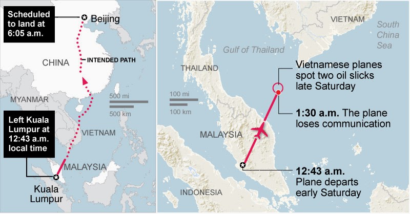
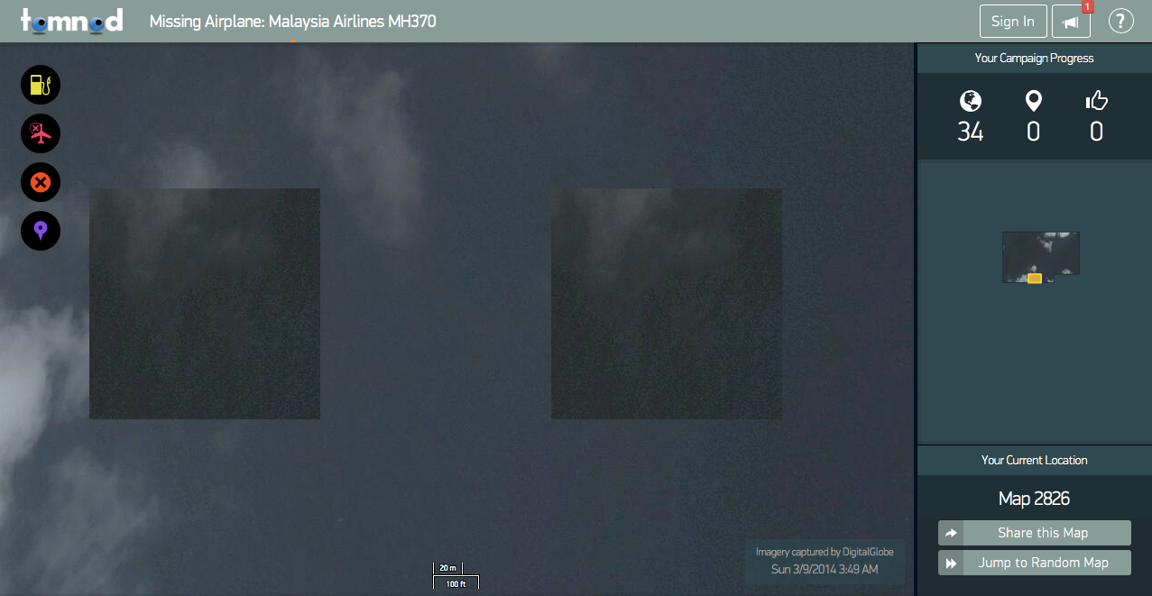
The DigitalGlobe satellite imagery is dated March 9th and covers over 1,000 square miles. What the Tomnod platform does is slice that imagery into many small squares like the one below (click to enlarge). Volunteers then tag one image at a time. This process is known as microtasking (or crowd computing). For quality control purposes, each image is shown to more than one volunteer. This consensus-based approach allows Tomnod to triangulate the tagging.
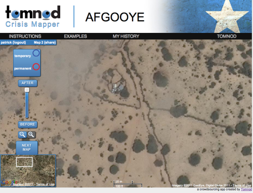
I’ve long advocated for the use of microtasking to support humanitarian efforts. In 2010, I wrote about how volunteers used microtasking to crowdsource the search for Steve Fossett who had disappeared while flying a small single-engine airplane in Nevada. This was back in 2007. In 2011, I spearheaded a partnership with the UN Refugee Agency (UNCHR) in Somalia and used the Tomnod platform to crowdsource the search for internally displaced populations in the drought-stricken Afgooye Corridor. More here. I later launched a collaboration with Amnesty International in Syria to crowdsource the search for evidence of major human rights violations—again with my colleagues from Tomnod. Recently, my team and I at QCRI have been developing MicroMappers to support humanitarian efforts. At the UN’s request, MicroMappers was launched following Typhoon Yolanda to accelerate their rapid damage assessment. I’ve also written on the use of crowd computing for Search & Rescue operations.
I’m still keeping a tiny glimmer of hope that somehow Malaysia Flight 370 was able to land somewhere and that there are survivors. I can only image what families, loved ones and friends must be going through. I’m sure they are desperate for information, one way or another. So please consider spending a few minutes of your time to support these Search and Rescue efforts. Thank you.

Note: If you don’t see any satellite imagery on the Tomnod platform for Flight 370, this means the team is busy uploading new imagery. So please check in again in a couple hours.
See also: Analyzing Tweets on Malaysia Flight #MH370 [link]

This is a fantastic effort, and a brilliant way to use the technology. Well done to yourself for advocating, and the team at Tomnod for implementing.
Thanks for reading, Julia, and for your kind words. This is a big team effort.
i found something how do you report it
Hi Steve, report it via the Tomnod platform.
See no way to d ok so. Also site was having issues
This is great. Why not start with satellite imagery that can capture the plane while it was on it’s still known course. Then, begin following focused areas with near that as time progresses beyond its time of last contact.
Hi M, thanks for reading. Commercial satellite companies make money by selling satellite imagery. More often than not, having high resolution imagery of a relatively large area of an ocean is of very little interest to clients. Land-based imagery is what sells. That’s why the imagery of the flight while it was airborne in the middle of the ocean is not available.
Reblogged this on My Soul 2.0 and commented:
Using the crowd to search for the missing flight is an excellent idea. I’ll lend my eyes once the server is back up.
To prevent the web app from crashing use TraceView from AppNeta. It will instantly pinpoint issues on the back end. http://www.appneta.com/products/traceview/
Fantastic idea!!! Was hoping we can get some land based shots of the area(Islands etc) Apparently It’s been confirmed that relatives have rang the mobiles of some passengers and the phones rang (had a dial tone) but had no answer, interesting for a plane they think came down in the ocean…
This really is great, it seems the Malaysian authorities need all the help they can get!!!
Congratulations. Finally technology is being used for the good of all. Good job sir.
Reblogged this on Dissident's Chaos and commented:
What a great team effort for all those involved, lets hope there is some answers soon.
doesnt mean those phones rang with the owners.. they could have been lost or stolen or left behind or discarded before the flight.
Can tomnod add a search area in the strait, land and air between both malaysian airports. Thank you, JG
Hi trying to sign in to help on tomnod. Been saving my info forever and can’t get to a password page yet. Also, there is a certain area I would like to check, been having dream about it for two days. Am I able to pick my area?
Hi Orianna, sorry about the trouble. Tomnod still has to work on scalability. Best to contact them directly for any questions. Thank you!
Orianna expressed one of my questions: (a) Been saving forever and cannot get to sign-in form yet. Other questions are (b) why cannot I know the Lat/Long of where I am searching? (c) And why cannot I have feedback on my efforts. And (d) why is mini-map losing my looked-at pages and (e) why does it not show my clicks.
Thanks John, all good questions. The team behind this project is Tomnod, so best to contact them directly as I do not have all the answers. Thanks again.
Thanks. New problem if you talk to them again. Tomnod keeps sending me to the gulf of China exact spot the plane vanished ALL day. I’m just wasting me time literally 12 hours + hours of it. We have known about search going west OFFICIALLY now for 4 hours, and the site says they have maps of the adaman islands, and the Indian Ocean, but none are loading for me. I’m on two FB search groups and everyone is having the same problem and they feeler are wasting their time. Though FB tomnod page and my search group page of 1000+ on our page! NO one has gotten a map later than March 11 and no one has gotten anything north or west of malacca strait, and only 3 ppl have reported land from the straight area. We have been checking our maps via the map Id lat/long on google maps. Disappointing. I might as well just go to bed. Don’t think I’ll do anything with tomnod again. 😦 Orianna
Sent from my iPad
>
Thanks Oriannna, I think the Tomnod folks are learning a lot about how to do this better in the future if there is a next time. Keep in mind that much of the delay is actually not their fault. Capturing high resolution satellite imagery of the area first requires that the satellite be overhead (which I believe only happens once or twice a day). Then this imagery has to be sent from the satellite to Earth, and because it is a very, very large file, it takes time. And it takes additional time to then slice up the imagery into micro-images and to upload these to the Tomnod platform where volunteers can tag the images. So while the Tomnod platform is not perfect, some of the issues you are experiencing are simply not in their control. Perhaps the biggest lesson they may learn, however, is that they need to be much better at communicating what I’ve just shared and making sure they respond as best they can to the most active and committed volunteers like you. I’ll do my part and forward them your comments. Sorry you’re frustrated, Orianna, hope you get some good sleep. Take care, and thanks for sharing your feedback.
Tomnod platform sucks!!! I have wasted hours upon hours. And now, 4 hours after official hijack and everyone look west statement the maps keep sending me to China sea at exact location of lost contact and no map later than the 11th even though they keep saying they have new maps for Indian Ocean, Andaman Islands ect, but good luck getting them. Waste of 12 hours. Yup I’m an idiot.
Pingback: Results of the Crowdsourced Search for Malaysia Flight 370 | iRevolution
Pingback: Crowdsourcing the Search for Malaysia Flight 370 | 9 Clouds
Tomnod sucks, it takes you to an image a million people have already seen and you have to move frame by frame, it’l take you hours to get to a spot that hasn’t been checked before, so only a few will be able to check far zones, they should let you see in a zoomed out map, where you want to start looking, that way all the map gets checked better.
Thanks for sharing, Petes. Best to communicate this directly to Tomnod. I don’t work for, or represent Tomnod.
Pingback: Launching a Search and Rescue Challenge for Drone / UAV Pilots | iRevolution
The quality of the images is very
good
, but Tomnod needs to allow the user to select where they would like to search, rather than just assigning a random chunk of ocean. It’s frustrating when you have no idea where you are.
I want DigitalGlobe to come out on top. How long after tagging possible wreckage is the information evaluated? Can it be evaluated while I’m still searching current maps? Or could it take days? Timing is everything.
Pingback: Launching a Search and Rescue Challenge for Drone | Drone NOW | Pagonal_UAV
Pingback: Live: Crowdsourced Verification Platform for Disaster Response | iRevolution
Pingback: Launching a Search and Rescue Challenge for Drone | Drone NOW | BLOG