Category Archives: Humanitarian Technologies

Crisis Mapping at Mobile Active ‘08

Erik Hersman (Ushahidi), Robert Kirkpatrick (InSTEDD) and Christopher Fabian (UNICEF) led an excellent panel on mobile technology in disasters and crises. Erik gave an superb presentation on Ushahidi 2.0 due to be released in the coming weeks. The functionalities that the Ushahidi team has added to the platform are just spot on and really well thought through. I’m very excited for the open source tool to get out into public hands very soon. In the meantime, I will be helping the team test the upgraded tool over the coming weeks.

Robert gave a more technical-oriented presentation on InSTEDD’s latest toy, Mash4X. While I think I grasped the basics and ultimate purpose of the new tool, much of the platform’s description was rather technical. Robert did mention to me later on that they (InSTEDD) are still trying to hit the right notes when they present their work to a non-technical audience. I suggested he give more basic examples, real-world scenarios in which the tool could be used. Robert also showed screenshots of GeoChat which he had described to me back in November 2007.

Christopher presented some of the projects UNICEF is engaged in such as the development of a new laptop computer that can be used in crisis environments. He emphasized the importance of collaborating with groups like Ushahidi and InSTEDD.

Patrick Philippe Meier

Two Way SMS Gateway on a USB Stick with Drupal

Just got word of this from a good friend of mine, Drew Bennett, a Fletcher School alumnus (F’08). Development Seed has been developing some very neat communications solutions. It’s tempting to write about all their creative projects but I’ll try my best to limit myself to one in particular which draws on new open source tools to make decentralized data collection more effective. From the developers themselves:

The release of the SMS Framework 1.0, along with the road map for a 1.1 version, is making Drupal a more attractive platform for organizations that need powerful, decentralized data collection tools. This recent work shows that using Drupal can give you a serious foundation to integrate sms applications and tools with a website. I want to expand on Will’s recent post about building a two way SMS Gateway on a USB drive and show how Drupal can act as a data hub for collecting data and messaging via sms.

We are interested in this because tools that can integrate with sms like this will be especially helpful for international development agencies with on the ground operations. For example, this functionality could allow an election monitoring organization to use sms to track reports from observers at polling stations or help a public heath organization to monitor when patients take medicine via sms messages sent from personal or public cell phones. It could even assist a disaster response organization to track the status of its team on the ground team through their handsets.

This tool could be particularly interesting for field based organizations operating in conflict zones as well. See also the group’s introductory overview of all their other projects here (PDF), which includes some very interesting dynamic mapping platforms.

Patrick Philippe Meier

SMS and Web 2.0 for Mumbai Early Warning/Response Project

I’m on my way back from a particularly fruitful and productive mission to Mumbai. As noted in my earlier blog, the purpose of the mission was to explore possibilities for partnership and collaboration vis-a-vis “upgrading” Mumbai city’s disaster early warning/response system. We chose to focus first on the Monsoons (which necessarily includes an important public health component).

Thanks to our fellow HHI colleague, the legendary Dr. Satchit Balsari, we met with all the key stakeholders in a whirlwind tour that included heavy rains, seemingly suicidal drivers, the amazing Ganesh festival and countless hours of near infinite traffic. All a very low price to pay for the energy and proactive engagement that emerged in our meetings, which ranged from high level political officials to leading professors based in Mumbai. Our presentations on crisis mapping platforms were also very well received, with comments including: “That’s exactly what we need.” Equally importantly, we saw numerous slums (picture below) along with the depressing conditions that slum dwellers have to live in. Naturally, they are the most vulnerable populations in Mumbai city, and our project will only be successful if it makes a difference in their lives.

Below is a picture of the control room headquarters for Mumbai city’s disaster early warning and response center. Note the red phones, each with a direct link to a government agency. It was interesting to note that apart from Autocad, the control room was not making any use of mapping software; all maps appearing in hardcopy. The center recently carried out a major vulnerability analysis of the entire city, which now comprises over fifty pages of very rich, albeit dense, structural data. This data has not been mapped.

Our proposal was rather simple: develop a web-based interface using Google Maps that allows for easy mapping of structural and dynamic (event-data). In addition to manual mapping, allow live, automated (meteorological) feeds from the control room’s computers, to be visualized within Google Maps in real time. Integrate SMS broadcasting directly within the Google Maps interface; thereby encouraging us to think of dynamic maps as communication tools in addition to tools for situational awareness. This follows Ushahidi’s approach of crowdsourcing crisis information.

The importance of two-way SMS broadcasting for this project cannot be overemphasized. Some 75% of Mumbai’s residents own a mobile phone (note that 55% of Mumbai is composed of slums). By some measures, Mumbai is the fourth largest city in the world, with a population of some 16 million. With this size comes some obvious challenges. I had pitched FrontlineSMS as a potential solution during my presentations, but I don’t know how scalable the software is. Can the platform handle millions of text messages in a matter of days? Ken Banks is kindly looking into this for us (thanks again, Ken). Another challenge is whether the bandwidth of Mumbai city will be able to handle such high traffic.

We will be following up on these questions and conversations shortly, and will be scheduling another mission to Mumbai in the next few months to formalize our partnerships and finalize the operational framework. As always, I welcome any and all (constructive) feedback.

Patrick Philippe Meier

Flood Warning, Mobile Phones and Dynamic Mapping in India

I’m in Mumbai for the next 10 days to work on a flood early warning and response project. Here’s a quick overview of the project:

The Monsoon Project
In Mumbai and Ahmedabad, we will see what kind of qualitative data people have reported. The next step is to to expand the data collection exercise to discreet objective data points that may expedite rescue and response in real-time. Can farmers sitting atop roofs in the flooded villages of Orissa use their cell phones to transmit simple, discreet, data points that would help plot a real-time map of events as they unfold? Can such a platform be created? How far are we in terms of technology and collaboration? At HHI, the Crisis Mapping Project is well underway, with small projects at multiple locations in different stages of development.

The Monsoon project is one such: To pilot such an interactive platform we need a predictable, controlled model within which to test such an instrument. In recent years, the monsoons in Mumbai have invariably brought the city to a stand-still. What we want to do now is to see if we can develop simple indicators that the common man can identify (“early warning signs”) to alert their communities to an impending “bad-floods day” in Mumbai. This monsoon Gregg Greenough and Patrick Meier from HHI will be in Mumbai to meet with the faculty at the Geography Dept of Mumbai University to explore ways to collaborate on developing these indicators. Site visits in Mumbai before and after the workshop.

Action points: Request MU/ AIDMI / CEE  to identify local partners in India that should be invited to the workshop. Once the indicators are identified, the goal is to test the technology on a local platform, amongst pre-selected volunteers across the city, during the monsoons of 2009.

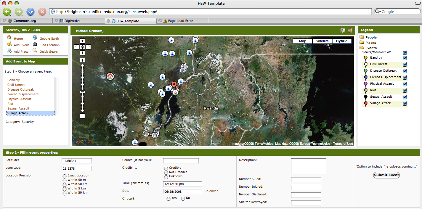
My role, as part of the HHI team, is simply to provide a conceptual and technical overview of other crisis early warning projects that make use of mobile technologies. For example, I got the green light from Ory Okolloh to consider a potential partnership with the team in Mumbai should making use of the Ushahidi platform make sense for the Monsoon Project. (Incidentally, congratulations to the Ushahidi team on launching their most recent version of the platform!) In addition to Ushahidi and a number of other related initiatives, I will share the latest maps of Bihar on Google Earth to stimulate a dialogue on whether this type of dynamic mapping is operationally useful (the map I’ve linked to here is not particularly impressive). In conclusion, I will share relevant best practices and lessons “learned” in the field of early warning and response.

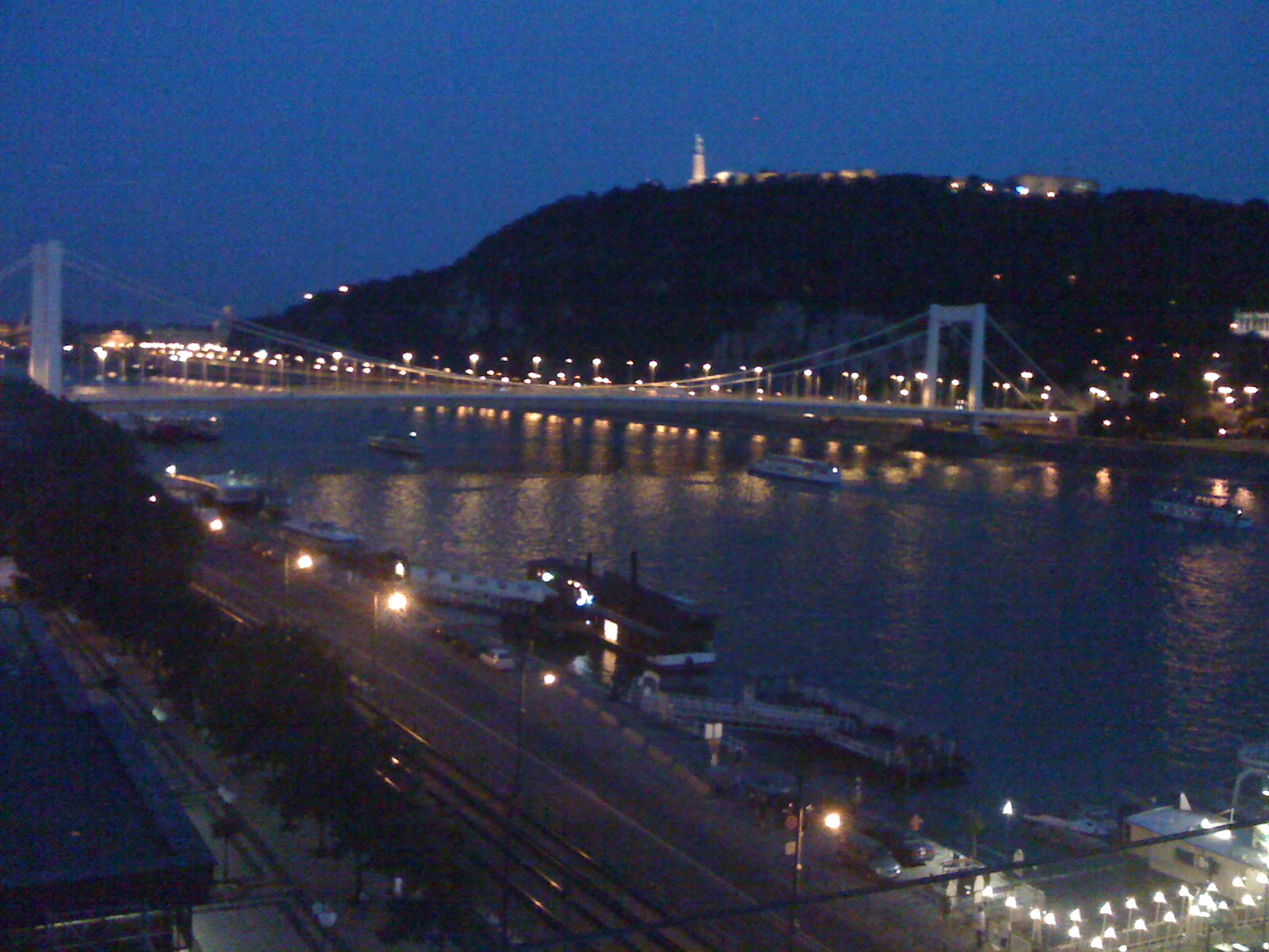
It may not be a coincidence that the National Geographic channel was just featuring a documentary on the great Mumbai floods of July 2005 yesterday. Watching these pictures and those of Bihar over the past two weeks, I’m starting to get some sense of the challenge ahead, not least because the topic of disaster management is an area I have more academic than practical experience in; so I’ll be doing a lot of listening and learning. Before leaving for Mumbai, I had the opportunity to touch base with a  friend at the Fletcher School who just returned from working on flood preparedness and response in Bihar.

In any case, I wanted to share some of my own observations. The government’s response to the devastation in the northeast of the country has been particularly slow, with just one military helicopter spotted once or twice in two weeks, according to a BBC report I saw yesterday.

If we are to make good on the UNISDR’s call for a shift towards people-centered early warning, then flood early warning/response systems ought to empower local communities to get out of harm’s way and minimize loss of livelihood. This shift in discourse and operational mandate is an important one in my opinion. Centralized, state-centered, top-down, external responses to crises are apparently increasingly ineffective.

In the case of the devastating floods of 2005, part of the problem was the late warning. The rains had already begun when India’s meteorological department realized that unlike monsoon storms, this storm had clouds as tall as 15 kilometers as opposed to the usual 8 kilometers.  Even if the warning had been disseminated hours or even days earlier, would the most vulnerable populations in Mumbai have had the capacity to get out of harm’s way? I don’t know what the Indian government’s operational plans look like for this type of disaster, but I hope to learn soon.

Another question on my mind is if/how mobile technology might empower vulnerable communities in Mumbai during the Monsoon season? As it happens,  the front page of today’s (Sunday print edition) of The Times of India figured an article on mobile phones: “A Mobile in Every Hand by 2020.” I include some sections below:

Today, one in four Indians has a mobile phone. […] From the villager sitting atop his half-drowned hut calling for help in flood-hit Bihar, to the kabadiwallah who eagerly hands you his number, it’s mobile networking like never before.

“[…] the mobile phone’s ‘greatest impact [will] be on those people with professions that are time, location and information sensitive. […] fishermen wanting a weather update or the location of the best catch; hospitals contacting patients without a permanent address; SMSes on the Sensex.”

“It is true that network coverage and mobile penetration are still limited to certain areas. But, interestingly, as a study by the Center for Knowledge Societies (CKS) showed in Maharashtra, Up and Karnataka, many new mobile users belong to poorer areas with scarce infrastructure, high levels of illiteracy and low PC and internet penetration.”

I remember an interesting conversation I had last year with Suha Ulgen, the coordinator of the UN Geographic Information Working Group Secretariat (UNGIWIG), regarding an earthquake preparedness and response project he had worked on in Turkey. The team involved in the project used mobile technologies and GPS units to map the most vulnerable areas (e.g., buildings, bridges, etc) in various neighborhoods across the city. Together with local volunteers, they documented the neighborhoods in great detail during the day, and would upload all their data directly on to a dynamic mapping platform in the evenings.

This approach appeals to me for several reasons. First, the approach comes close to local crowdsourcing.  Tapping into local knowledge is critical. As mentioned in this article (PDF) I wrote for Monday Developments (April/2007), “From Disaster to Conflict Early Warning: A People-Centered Approach,” the non-local community (a.k.a. international community) has a lot to learn when it comes indigenous early warning and response practices:

In Swaziland, for example, we are taught floods can be predicted from the height of bird nests near rivers, while moth numbers predict drought. Because these indicators are informal, they rarely figure in peer-reviewed journals and remain invisible to the international humanitarian community.

I’m looking forward to learning more about the corresponding local know how in Mumbai. Second, vulnerability mapping is an important component of preparedness training, contingency planning and disaster response. Third, geo-referencing pockets of vulnerability using a dynamic platform provides a host of new possibilities for disaster response including automated and subscription-based SMS alerts, rapid disaster impact assessments and more networked forms of communication in crisis zones. In addition to mapping areas of vulnerability, one could also map potential shelter areas, sources of clean water, etc.

This may or may not make sense within the context of flooding and/or Mumbai, which is why I’ll definitely be doing a lot of listening and learning in the coming days. Any feedback and guidance in the meantime would certainly be of value.

Patrick Philippe Meier

MAPme: Applications for Humanitarian Mapping?

MAPme can be used to “create anything from travel guides for any entire country, or a detailed view of a specific street. The maps can be personal (and private if required) or community based (where content is moderated) or a complete free for all (where anyone can contribute). Hopefully these various map ‘types’ will give map creators enough flexibility to adjust the way that other people view and relate to the maps they create. Users can add images, videos and comments, which means that the map content can be dynamic. Other features are on the way, including the ability to add trails and a Facebook Application.”

Adding an SMS component like Ushahidi and the Humanitarian Sensor Web would make the tool even more interesting.

Patrick Philippe Meier

US Army Falling Behind in Digital Communication

Senior Army officials are increasingly concerned that they are missing out on the iRevolution, i.e., “the breakneck development of cheap digital communications including cell phones, digital cameras and Web 2.0 Internet sites such as blogs and Facebook,” according to Wired.

That helps explain how “just one man in a cave that’s hooked up to the Internet has been able to out-communicate the greatest communications society in the history of the world—the United States,” says the US Army Secretary Pete Geren.

One solution: “Find a blog to be a part of,” Geren said.

But embracing that high-tech, second language could be hard for the Army, just as it poses challenges for the defense industry.”I was talking to a senior executive this week, one of our major defense contractors,” Geren recounted. “And he said that they’ve assigned a young person to every senior executive to be like his or her translator and connect with the new information technologies.”

At the U.S. Military Academy in West Point, a tiny office of Web-savvy mavericks is creating Army-specific Web 2.0 tools (blogs, forums, social networks) for soldiers. Meanwhile, the Air Force, the Pentagon’s main agency for “cyberwarfare,” continues to  view the Internet primarily as a battlefield to be “dominated.”

Patrick Philippe Meier

Citizen Communications In Crisis

I recently spoke with Professor Leysia Palen at the University of Colorado, Boulder, about her Crisis Informatics research project and followed up by reading her co-authored paper entitled: “Citizen Communications in Crisis: Anticipating a Future of ICT-Supported Public Participation” published in 2007. The focus of Leysia’s publication overlaps with my previous blog entry on the intersection of citizen journalism (Global Voices) and conflict early warning/response.

Leysia provides a valuable and insightful sociological perspective that is often lacking in our own field.  Indeed, the sociology of disaster includes a public with its own impetus for participation that conventional conflict early warning/response systems rarely consider. Following are some excerpts from her paper that I found pertinent and interesting:

  • ICT in disaster contexts will give further rise to improvised activities and temporary organizations with which formal response organizations need to align.
  • The role held by members of the public in disaster—a role that has always been characterized as one of high involvement by disaster sociologists throughout the nearly century-long history of disaster research—is becoming more visible, active, and in possession of greater reach than ever seen before.
  • Our stance is that the old, linear model for information dissemination of authorities-to-public relations-to-media is outmoded, and will be replaced—at least in practice—by one that is much more complex. Peer communications technologies are a critical piece of these emergent information pathways.
  • Disaster social scientists have long documented the nature of post-disaster public participation as active and largely altruistic. “First responders” are not, in practice, the trained professionals who are deployed to a scene in spite of the common use of that term for them; they are instead people from the local and surrounding communities.
  • People are natural information seekers, and will seek information from multiple sources, relying primarily on their own social networks—friends and family—to validate and interpret information coming from formal sources, and then to calculate their own response measures.
  • The possibilities for public participation are expanding with increased access to the Internet and the wide diffusion of mobile technology—mobile phones, text  and multimedia messaging, and global positioning devices. This technology in the hands of the people further pushes on boundaries between informal and formal rescue and response efforts, and has enabled new media forms that are broadly known as citizen journalism.
  • For example, wikis enable broad participation in the creation and dissemination of information. Some visual wikis use mapping technology for linking textual or photographic information to representations of physical locations, thereby documenting, for example, the extent of damage to a specific neighborhood. Recent disasters show how people, whom we already know will seek information from multiple sources during uncertain conditions, have fueled the proliferation and utility of these sites. In this way, the public is able to take not only a more active part in seeking information, but also in providing information to each other, as well as to formal response efforts.
  • Emerging ICT-supported communications in crisis will result in changing conditions that need to be addressed by the formal response. ICT-supported citizen communications can spawn, often opportunistically, information useful to the formal response effort. Citizen communications can also create new opportunities for the creation of new, temporary organizations that help with the informal response effort. The idea of emergent or ephemeral organizations that arise following disaster is not at all new; in fact, it is one of the hallmarks of disaster sociology, and supports the need for communities to be able to improvise response under uncertain and dynamic conditions. ICT-supported communications, however, add another powerful means by which this kind of organization can occur. No longer do people need the benefit of physical proximity to coordinate and serendipitously discover each other.
  • Implications for Relief Efforts: As the reach of response extends to a broader audience with ICT, how will the formal response effort align with, support and leverage wider community response? Relief work—the provision of food, shelter and basic necessities—already largely arises out of volunteerism through either grassroots efforts or managed through official channels.

Patrick Philippe Meier

Survey on Information Management & Sharing in Crisis Response Situations

On behalf of the Crisis Management Initiative, IASCI is conducting a research project related to information management and sharing in crisis response situations. IASCI is contacting fellow practitioners from key institutions and agencies to canvas their expert views and experiences regarding information systems and features of utility, and to learn about primary information gaps and constraints.

If you are professionally familiar with crisis response, either from the field or management perspectives, CMI and IASCI would very much appreciate if you could take a few moments to respond to our questions under the following link:

Online Survey

If you have any questions or suggestions, you can contact IASCI at info@iasci.info

Patrick Philippe Meier

The Burmese Cyclone, Nonviolent Action, and the Responsibility to Empower

I just got this piece published in PeaceWorks:

Repressive regimes continue to play the sovereignty card regardless of international condemnation, and the military regime in Burma is no exception. Prior to the cyclone disaster, the regime maintained an effective information blockade on the country, limiting access and communication while forcefully cracking down on the pro-democracy resistance movement.

The military regime’s decision to block humanitarian aid following the cyclone disaster should really come as no surprise. The international community clearly remains at the mercy of regimes that scoff at the Responsibility to Protect.

The Responsibility to Protect (or R2P, as endorsed by UN Security Council Resolution 1674, affirming the responsibility of all to prevent or stop genocide, war crimes, ethnic cleansing, or crimes against humanity) is a noble principle: sovereignty is contingent upon the state’s ability to protect its citizens. Burma’s military regime has shown absolutely no interest in doing so, but quite the opposite—even in the case of a “natural” disaster. French Foreign Minister Bernard Kouchner has advocated that the principle of R2P justifies overruling the Burmese military junta’s right to territorial sovereignty.

Originally, Gareth Evans, Director of the International Crisis Group, strongly disagreed, arguing that Kouchner’s approach would create a precedent to intervene in post-disaster environments, which would potentially undermine the general consensus that currently exists in the developing world vis-à-vis R2P. Many other humanitarians have also voiced their opposition to engaging in non-authorized intervention. They (mistakenly) assumed such intervention requires the use of force. The result? An international community yet again bowing down to the wishes of a repressive regime; a terribly inadequate in-country humanitarian response to save lives; and an increasingly high death toll. It is high time that alternative approaches to humanitarian intervention be considered that depend less on potentially resistant governments — approaches such as people-centered tactics and nonviolent action. In other words, what nonviolent options exist for civilian protection and non-consensual humanitarian intervention? Continued…

Patrick Philippe Meier

Global Voices and Humanitarian Action

What a treat, I’ve been in the beautiful city of Budapest for a week to participate in both the 2-day Berkman Center conference on Internet and Democracy as well the 3-day Global Voices 2008 Summit. Out of some 200+ participants I was one of three with active links to the humanitarian community. My other two colleagues were Sameer Padania of The Hub at Witness and Ivan Sigal from USIP. There should have been more but three is a start.

It is becoming increasingly clear to me that there really is something to the hunch I’ve had over the past year. Namely that the various “fields” of activist blogging a la Global Voices, nonviolent action, humanitarian technology, conflict prevention and crisis response are not as distinct as one might think.

Take Ushahidi, for example, which was developed by several bloggers following Kenya’s elections in December 2007. The field of conflict early warning/response is increasingly shifting towards crisis mapping, which is in effect what Ushahidi is. I find this convergence of interests from different areas of expertise particularly exciting.

Indeed, I’ve been working since June 2007 (one year now) on a crisis mapping tool called the “Humanitarian Sensor Web” (or HSW) to facilitate dynamic, real-time mapping of humanitarian infrastructure and crisis-related events. The Sensor Web includes SMS and we too are looking at using Jott to allow for voice-to-text data collection.

Erik Hersman and I had a particularly fruitful day-long brainstorming session in April 2008. He was interested in the lessons learned and best practices from the humanitarian side while I wanted to learn more about the technical aspect of crisis mapping. The conflict early warning community has had to address the challenges of information collection, data validation (quality control), indicator development and frameworks, data analysis, field-based security of monitors, etc.

I think we have a lot to offer and a lot to learn from the activist blogging community. They are often closer to the ground than some of us in the humanitarian community are. They have their ears to the ground, are part of a local  social and information network, provide critical information when the mainstream media becomes unreliable or inaccessible in times of conflict, and have shown time and time again that they can mobilize a movement for action. Isn’t that what conflict prevention is about?

This is part of a broader conversation that we will be having with other colleagues at an upcoming workshop in Boston hosted by the Harvard Humanitarian Initiative (HHI), where I am a doctoral research fellow. The workshop will explore, amongst other issues, the application of information communication technology for conflict early warning, crisis mapping and humanitarian response. Sameer from Witness will be joining us, as well colleagues from Microsoft‘s Humanitarian Information Systems Group, the Geotechnology and Human Rights project at AAAS, the Eyes on Darfur project at Amnesty International (AI), the US Holocaust Memorial Museum (USHMM), and many more (we’ll be about 20 in all).

I’ll be sure to share all that I have learned from participating in the Global Voices summit during the HHI workshop. It is time we bridge our respective fields of practice and exchange best practices.

Patrick Philippe Meier