
My colleague Leysia Palen recently co-authored an important study (PDF) on tweets posted during last year’s major floods in Colorado. As Leysia et al. write, “Because the flooding was widespread, it impacted many canyons and closed off access to communities for a long duration. The continued storms also prevented airborne reconnaissance. During this event, social media and other remote sources of information were sought to obtain reconnaissance information […].”

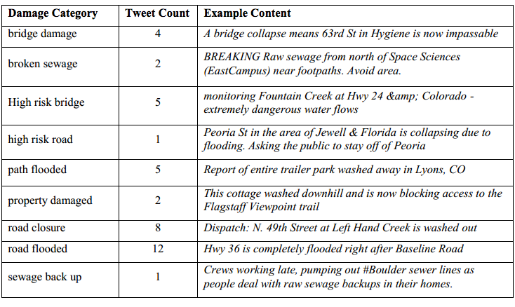
The study analyzed 212,672 unique tweets generated by 57,049 unique Twitter users. Of these tweets, 2,658 were geo-tagged. The researchers combed through these geo-tagged tweets for any information on infrastructure damage. A sample of these are included below (click to enlarge). Leysia et al. were particularly interested in geo-tagged tweets with pictures of infrastructure damage.
They overlaid these geo-tagged pictures on satellite and UAV/aerial imagery of the disaster-affected areas. The latter was captured by Falcon UAV. The satellite and aerial imagery provided the researchers with an easy way to distinguish between vegetation and water. “Most tweets appeared to fall primarily within the high flood hazard zones. Most bridges and roads that were located in the flood plains were expected to experience a high risk of damage, and the tweets and remote data confirmed this pattern.” According to Shideh Dashti, an assistant professor of civil, environmental and architectural engineering, and one of the co-authors, “we compared those tweets to the damage reported by engineering reconnaissance teams and they were well correlated.”

To this end, by making use of real-time reporting by those affected in a region, including their posting of visual data,” Leysia and team “show that tweets may be used to directly support engineering reconnaissance by helping to digitally survey a region and navigate optimal paths for direct observation.” In sum, the results of this study demonstrate “how tweets, particularly with postings of visual data and references to location, may be used to directly support geotechnical experts by helping to digitally survey the affected region and to navigate optimal paths through the physical space in preparation for direct observation.”
Since the vast majority of tweets are not geo-tagged, GPS coordinates for potentially important pictures in these tweets are not available. The authors thus recommend looking into using natural language processing (NLP) techniques to “expose hazard-specific and site-specific terms and phrases that the layperson uses to report damage in situ.” They also suggest that a “more elaborate campaign that instructs people how to report such damage via tweets […] may help get better reporting of damage across a region.”
These findings are an important contribution to the humanitarian computing space. For us at QCRI, this research suggests we may be on the right track with MicroMappers, a crowdsourcing (technically a microtasking) platform to filter and geo-tag social media content including pictures and videos. MicroMappers was piloted last year in response to Typhoon Haiyan. We’ve since been working on improving the platform and extending it to also analyze UAV/aerial imagery. We’ll be piloting this new feature in coming weeks. Ultimately, our aim is for MicroMappers to create near real-time Crisis Maps that provide an integrated display of relevant Tweets, pictures, videos and aerial imagery during disasters.

See also:

While I agree with the concepts outlined in the article, I think that as the initiator of the Humanitarian UAV Network, any link to the one-sided IEEE article re the Falcon work and the USG “freaking out” should also reference the airspace restrictions at the time and the ongoing rescue operations in that airspace. While the aerial imagery is absolutely valuable, publicly disparaging the importance of other components of a response is not a way to create positive relationships within the emergency management community. I’m not sure I’d hold this up as a good example of UAV imagery operations.
Thanks for reading and glad you agree with the concepts outlined since that was the point of the article. I frankly wrote this up very quickly and didn’t have the time to read through the IEEE article carefully. I simply assumed that IEEE is a well-respected scientific community. Please send me a few links that provide a more balanced overview of what happened re the UAVs and I’ll add those to the blog post. Again, I want to be clear that the focus of the blog post is on the concepts and not at all about the UAV operation itself or any controversies around that particularly data collection tool. Thanks again for reading.
Horrible Disaster!!, i wonder if you found some similar idea about Satellite Image Analysis in here http://www.imagesatintl.com/services/satellite-image-analysis/