Tag Archives: Crisis Mapping

Crisis Tech at Mobile Active ‘08

It’s been an eventful three days here in Jo’burg. During Day 2 of the Mobile Active 2008 conference, participants were invited to propose topics for self-organized sessions. I think this was a fabulous idea; some 20+ self-organized sessions took place.

I therefore proposed and moderated one of these sessions, which was entitled “Mobile Communication and Crisis Mapping in Conflict.”

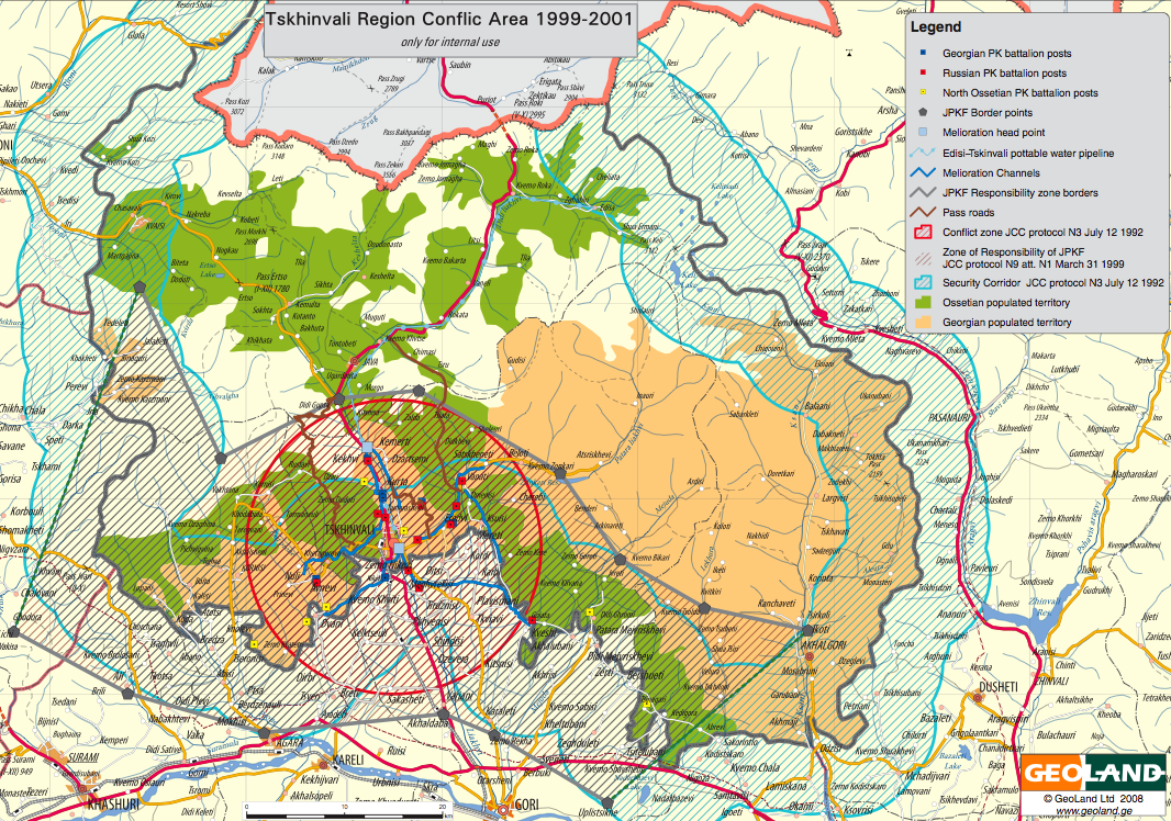
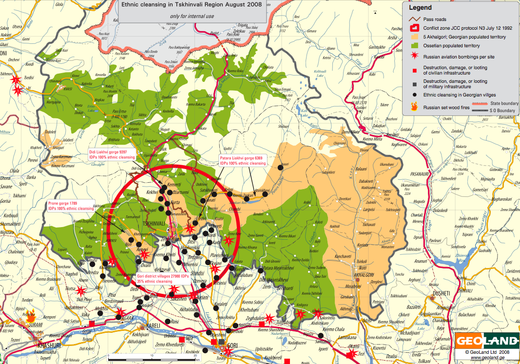
The purpose of this session was to bring together those of us interested in making the most effective use of ICTs in conflict zones and repressive environments. Most effective use of ICTs to what end? For conflict early warning/response, civilian protection, nonviolent action and pro-democracy resistance movements, digital activism and disaster response.

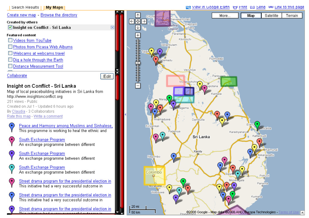
Our friends and colleagues from Ushahidi, Global Voices, Digital Democracy, InSTEDD, UNDP, UNICEF and many more actively participated in the discussion, which lasted over an hour. The main issues addressed included:

  • Connectivity
  • Physical security
  • Data security

On connectivity, the use of satellite phones and VHF radios was broached. The former are cheaper in Burma than regular mobile phones. The importance of making phone credit available during Kenya’s post-election violence was emphasized. One participant suggested that Telecoms make SMS’s free during times of crises, or at least provide subscribers with 10 free SMS’s.

We discussed the problem of congested phone networks during crises and one participant made the observation that Telecoms have little to no incentives for creating redundancy. How do we tackle this? Perhaps, as some suggested, by taking a major initiative such as creating a consortium and launching our own satellites. Others suggested working within existing constraints and identifying creative solutions in the meantime; for example, adding information on early response to “please call me” messages.

Another problem vis-à-vis connectivity is when mobile phone towers go down, or are deliberately shut down by repressive governments. I shared information on a project at MIT that seeks to render mobile phones peer-to-peer technologies, much like file sharing online. This does away with the need for mobile phone towers. As long as trusted individuals are in sufficient proximity, your message (text or voice) can be transmitted through your trusted network of contacts.

I had learned about this project from a colleague earlier that day, and I still think that this initiative is potentially the most revolutionary one I heard about throughout the Mobile Active conference. I’ll be following up with the PhD student working on this project in Boston next week.

On physical security, one participant noted the problem of civilians seeking points of high elevation in order to get phone reception; this regularly places these civilians at risk of nearby snipers. One donor in the room highlighted the constraints they face in funding projects that place individuals in danger. Another participant, who has worked in Iraq and Afghanistan pointed out that being caught with a mobile phone can result in torture and death.

The location of mobile phones can easily be tracked even if the phones are switched off, so I emphasized the importance of removing batteries in order not to be tracked. I also recounted a tactic used by activists in Pakistan back in November 2007, who would send text messages our while driving all around the city, and also using SMS2Blog software to update their blogs in the same way. This surefire way prevented the government from locating the activists. Participants also recommended security guides developed for journalists operating in conflict zones. Tactical Tech’s guides were also highlighted.

On data security, participants highlighted the problem of address books in mobile phones not being encrypted. This poses serious problems when mobile phones are confiscated, since they can then be used to track down collaborators. From a technical point of view, encrypting address books would be perfectly straightforward. One participant who has good contacts with the Android team said he would follow up and recommend an encrypted functionality for address books.

There are also tactical measures that one can take by using false names, as one participant did in Palestine before Israeli soldiers confiscated his phone. SMS encryption was another point raised during the self-organized session. While open source software like CryptoSMS exists, they tend to be difficult to use.

Patrick Philippe Meier

Crisis Mapping at Mobile Active ‘08

Erik Hersman (Ushahidi), Robert Kirkpatrick (InSTEDD) and Christopher Fabian (UNICEF) led an excellent panel on mobile technology in disasters and crises. Erik gave an superb presentation on Ushahidi 2.0 due to be released in the coming weeks. The functionalities that the Ushahidi team has added to the platform are just spot on and really well thought through. I’m very excited for the open source tool to get out into public hands very soon. In the meantime, I will be helping the team test the upgraded tool over the coming weeks.

Robert gave a more technical-oriented presentation on InSTEDD’s latest toy, Mash4X. While I think I grasped the basics and ultimate purpose of the new tool, much of the platform’s description was rather technical. Robert did mention to me later on that they (InSTEDD) are still trying to hit the right notes when they present their work to a non-technical audience. I suggested he give more basic examples, real-world scenarios in which the tool could be used. Robert also showed screenshots of GeoChat which he had described to me back in November 2007.

Christopher presented some of the projects UNICEF is engaged in such as the development of a new laptop computer that can be used in crisis environments. He emphasized the importance of collaborating with groups like Ushahidi and InSTEDD.

Patrick Philippe Meier

Using Satellites for Human Rights Monitoring

The journal Disasters just published an interesting piece entitled “Images of War: Using satellite images for human rights monitoring in Turkish Kurdistan.” The authors conclude that satellite images are “useful to validate witness reports of forest fires [and while] the use of this technology for human rights groups will depend on some feasibility factors such as prices, access and expertise, the images proved to be key for analysis of spatial aspects of conflict and valuable for reconstructing a more trustworthy picture.”

Other points from the publication worth noting:

Our study has proven that even with limited resources it is possible to combine remote sensing with local witness reports, when they include information about time and place. Depending on the kind of human rights violations being monitored, costs may vary significantly. As we focussed here on burned forests we could use the cheaper Landsat images. Our method of a remotely-sensed analysis (in our case by means of satellite images) is based on the availability of information about the area under study. Even without high resolution satellite images we were able to show the structural nature of village destruction.

See my other related blog entries on “Tracking Genocide by Remote Sensing” here and on “Human Rights 2.0” here.

Patrick Philippe Meier

SMS and Web 2.0 for Mumbai Early Warning/Response Project

I’m on my way back from a particularly fruitful and productive mission to Mumbai. As noted in my earlier blog, the purpose of the mission was to explore possibilities for partnership and collaboration vis-a-vis “upgrading” Mumbai city’s disaster early warning/response system. We chose to focus first on the Monsoons (which necessarily includes an important public health component).

Thanks to our fellow HHI colleague, the legendary Dr. Satchit Balsari, we met with all the key stakeholders in a whirlwind tour that included heavy rains, seemingly suicidal drivers, the amazing Ganesh festival and countless hours of near infinite traffic. All a very low price to pay for the energy and proactive engagement that emerged in our meetings, which ranged from high level political officials to leading professors based in Mumbai. Our presentations on crisis mapping platforms were also very well received, with comments including: “That’s exactly what we need.” Equally importantly, we saw numerous slums (picture below) along with the depressing conditions that slum dwellers have to live in. Naturally, they are the most vulnerable populations in Mumbai city, and our project will only be successful if it makes a difference in their lives.

Below is a picture of the control room headquarters for Mumbai city’s disaster early warning and response center. Note the red phones, each with a direct link to a government agency. It was interesting to note that apart from Autocad, the control room was not making any use of mapping software; all maps appearing in hardcopy. The center recently carried out a major vulnerability analysis of the entire city, which now comprises over fifty pages of very rich, albeit dense, structural data. This data has not been mapped.

Our proposal was rather simple: develop a web-based interface using Google Maps that allows for easy mapping of structural and dynamic (event-data). In addition to manual mapping, allow live, automated (meteorological) feeds from the control room’s computers, to be visualized within Google Maps in real time. Integrate SMS broadcasting directly within the Google Maps interface; thereby encouraging us to think of dynamic maps as communication tools in addition to tools for situational awareness. This follows Ushahidi’s approach of crowdsourcing crisis information.

The importance of two-way SMS broadcasting for this project cannot be overemphasized. Some 75% of Mumbai’s residents own a mobile phone (note that 55% of Mumbai is composed of slums). By some measures, Mumbai is the fourth largest city in the world, with a population of some 16 million. With this size comes some obvious challenges. I had pitched FrontlineSMS as a potential solution during my presentations, but I don’t know how scalable the software is. Can the platform handle millions of text messages in a matter of days? Ken Banks is kindly looking into this for us (thanks again, Ken). Another challenge is whether the bandwidth of Mumbai city will be able to handle such high traffic.

We will be following up on these questions and conversations shortly, and will be scheduling another mission to Mumbai in the next few months to formalize our partnerships and finalize the operational framework. As always, I welcome any and all (constructive) feedback.

Patrick Philippe Meier

From Crime Mapping to Crisis Mapping?

Londoners now have access to an online crime map showing the numbers of robberies, burglaries and vehicle crimes across London. According to this BBC report, “People can type in their postcodes to get the statistics from their area and compare it to other parts of the city. The Metropolitan Police said the £210,00  [sic] site could be expanded to include other types of crime, clean-up rates and local crime-fighting plans. The interactive maps will display monthly crime figures as well as historical data so the public can see yearly trends.”

Several features about this dynamic map appeal to me:

  • Simple and intuitive;
  • Color coding of the different neighborhoods provides an immediate at-a-glance understanding of the distribution of crime across London;
  • Point-and-click pop-up boxes with the three tabs, “summary” (with arrow), “compare”, and “trends” provide additional easily understood information on the underlying statistics (hopefully they’ll add a simple graph to the “trends” tab);
  • “Key” box is kept very simple and the “Related Links” box on the lower-right provides information on prevention and response;
  • Good use of tabs “Map View”, “Terms”, “Help/FAQs”

I wonder what it would take to make this crime map more real-time and at higher spatial resolution? Would the Metropolitan Police have to rely more on a crowdsourcing approach and mobile technologies, like Ushahidi? How would they validate the reports?

Patrick Philippe Meier


Flood Warning, Mobile Phones and Dynamic Mapping in India

I’m in Mumbai for the next 10 days to work on a flood early warning and response project. Here’s a quick overview of the project:

The Monsoon Project
In Mumbai and Ahmedabad, we will see what kind of qualitative data people have reported. The next step is to to expand the data collection exercise to discreet objective data points that may expedite rescue and response in real-time. Can farmers sitting atop roofs in the flooded villages of Orissa use their cell phones to transmit simple, discreet, data points that would help plot a real-time map of events as they unfold? Can such a platform be created? How far are we in terms of technology and collaboration? At HHI, the Crisis Mapping Project is well underway, with small projects at multiple locations in different stages of development.

The Monsoon project is one such: To pilot such an interactive platform we need a predictable, controlled model within which to test such an instrument. In recent years, the monsoons in Mumbai have invariably brought the city to a stand-still. What we want to do now is to see if we can develop simple indicators that the common man can identify (“early warning signs”) to alert their communities to an impending “bad-floods day” in Mumbai. This monsoon Gregg Greenough and Patrick Meier from HHI will be in Mumbai to meet with the faculty at the Geography Dept of Mumbai University to explore ways to collaborate on developing these indicators. Site visits in Mumbai before and after the workshop.

Action points: Request MU/ AIDMI / CEE  to identify local partners in India that should be invited to the workshop. Once the indicators are identified, the goal is to test the technology on a local platform, amongst pre-selected volunteers across the city, during the monsoons of 2009.

My role, as part of the HHI team, is simply to provide a conceptual and technical overview of other crisis early warning projects that make use of mobile technologies. For example, I got the green light from Ory Okolloh to consider a potential partnership with the team in Mumbai should making use of the Ushahidi platform make sense for the Monsoon Project. (Incidentally, congratulations to the Ushahidi team on launching their most recent version of the platform!) In addition to Ushahidi and a number of other related initiatives, I will share the latest maps of Bihar on Google Earth to stimulate a dialogue on whether this type of dynamic mapping is operationally useful (the map I’ve linked to here is not particularly impressive). In conclusion, I will share relevant best practices and lessons “learned” in the field of early warning and response.

It may not be a coincidence that the National Geographic channel was just featuring a documentary on the great Mumbai floods of July 2005 yesterday. Watching these pictures and those of Bihar over the past two weeks, I’m starting to get some sense of the challenge ahead, not least because the topic of disaster management is an area I have more academic than practical experience in; so I’ll be doing a lot of listening and learning. Before leaving for Mumbai, I had the opportunity to touch base with a  friend at the Fletcher School who just returned from working on flood preparedness and response in Bihar.

In any case, I wanted to share some of my own observations. The government’s response to the devastation in the northeast of the country has been particularly slow, with just one military helicopter spotted once or twice in two weeks, according to a BBC report I saw yesterday.

If we are to make good on the UNISDR’s call for a shift towards people-centered early warning, then flood early warning/response systems ought to empower local communities to get out of harm’s way and minimize loss of livelihood. This shift in discourse and operational mandate is an important one in my opinion. Centralized, state-centered, top-down, external responses to crises are apparently increasingly ineffective.

In the case of the devastating floods of 2005, part of the problem was the late warning. The rains had already begun when India’s meteorological department realized that unlike monsoon storms, this storm had clouds as tall as 15 kilometers as opposed to the usual 8 kilometers.  Even if the warning had been disseminated hours or even days earlier, would the most vulnerable populations in Mumbai have had the capacity to get out of harm’s way? I don’t know what the Indian government’s operational plans look like for this type of disaster, but I hope to learn soon.

Another question on my mind is if/how mobile technology might empower vulnerable communities in Mumbai during the Monsoon season? As it happens,  the front page of today’s (Sunday print edition) of The Times of India figured an article on mobile phones: “A Mobile in Every Hand by 2020.” I include some sections below:

Today, one in four Indians has a mobile phone. […] From the villager sitting atop his half-drowned hut calling for help in flood-hit Bihar, to the kabadiwallah who eagerly hands you his number, it’s mobile networking like never before.

“[…] the mobile phone’s ‘greatest impact [will] be on those people with professions that are time, location and information sensitive. […] fishermen wanting a weather update or the location of the best catch; hospitals contacting patients without a permanent address; SMSes on the Sensex.”

“It is true that network coverage and mobile penetration are still limited to certain areas. But, interestingly, as a study by the Center for Knowledge Societies (CKS) showed in Maharashtra, Up and Karnataka, many new mobile users belong to poorer areas with scarce infrastructure, high levels of illiteracy and low PC and internet penetration.”

I remember an interesting conversation I had last year with Suha Ulgen, the coordinator of the UN Geographic Information Working Group Secretariat (UNGIWIG), regarding an earthquake preparedness and response project he had worked on in Turkey. The team involved in the project used mobile technologies and GPS units to map the most vulnerable areas (e.g., buildings, bridges, etc) in various neighborhoods across the city. Together with local volunteers, they documented the neighborhoods in great detail during the day, and would upload all their data directly on to a dynamic mapping platform in the evenings.

This approach appeals to me for several reasons. First, the approach comes close to local crowdsourcing.  Tapping into local knowledge is critical. As mentioned in this article (PDF) I wrote for Monday Developments (April/2007), “From Disaster to Conflict Early Warning: A People-Centered Approach,” the non-local community (a.k.a. international community) has a lot to learn when it comes indigenous early warning and response practices:

In Swaziland, for example, we are taught floods can be predicted from the height of bird nests near rivers, while moth numbers predict drought. Because these indicators are informal, they rarely figure in peer-reviewed journals and remain invisible to the international humanitarian community.

I’m looking forward to learning more about the corresponding local know how in Mumbai. Second, vulnerability mapping is an important component of preparedness training, contingency planning and disaster response. Third, geo-referencing pockets of vulnerability using a dynamic platform provides a host of new possibilities for disaster response including automated and subscription-based SMS alerts, rapid disaster impact assessments and more networked forms of communication in crisis zones. In addition to mapping areas of vulnerability, one could also map potential shelter areas, sources of clean water, etc.

This may or may not make sense within the context of flooding and/or Mumbai, which is why I’ll definitely be doing a lot of listening and learning in the coming days. Any feedback and guidance in the meantime would certainly be of value.

Patrick Philippe Meier

MAPme: Applications for Humanitarian Mapping?

MAPme can be used to “create anything from travel guides for any entire country, or a detailed view of a specific street. The maps can be personal (and private if required) or community based (where content is moderated) or a complete free for all (where anyone can contribute). Hopefully these various map ‘types’ will give map creators enough flexibility to adjust the way that other people view and relate to the maps they create. Users can add images, videos and comments, which means that the map content can be dynamic. Other features are on the way, including the ability to add trails and a Facebook Application.”

Adding an SMS component like Ushahidi and the Humanitarian Sensor Web would make the tool even more interesting.

Patrick Philippe Meier

New Detailed South Ossetia and Georgia Maps

New highly detailed maps of South Ossetia provided by the Georgian Ministry of Internal Affairs. The titles associated with each map also comes from the Georgian government. I imagine these maps will eventually be available as KML files on Google Earth.

(1) Tskhinvali Region Conflict Area (1999-2001) [PDF]

(2) Ethnic Cleansing in Tskhinvali Region August 2008 [PDF]

(3) South Ossetia Ethnic Landscape Before Ethnic Cleansing [PDF]

(4) South Ossetia Ethnic Landscape After Ethnic Cleansing [PDF]

(5) Russian Invasion and Occupation of Georgia [PDF]

All maps (with the exception of 2 and 3) are accompanied by the explanatory legends and are otherwise self-explanatory.

Patrick Philippe Meier

Crisis Mapping and Peacebuilding

Insight on Conflict, initially mentioned on campus-adr, is a new portal dedicated to rendering more visible “the unknown, virtually invisible, civil society peacebuilding initiatives which exist in tens, hundreds or even thousands in every conflict area.” The goal of the project is to “make them visible to policy makers, the media and other peace practitioners.”

The portal enables users to map and track activities based on seven core themes:

  • Community Action
  • Culture & Media
  • Development
  • Human Rights
  • Religious and Ethnic Diversity
  • Women
  • Young People

The platform also allows users to navigate the web-based interface by region, and provides RSS feeds, detailed country profiles and interactive maps.

The User Guide includes a visual review of the key features of the site.

Patrick Philippe Meier

New Crisis Maps of Georgia

A new set of crisis maps of Georgia have been posted over the past few days. Jonathan Thomas has kept us well informed of these developments, which include a detailed map provided by Microsoft, an OCHA map and updated layers on Google Earth, all pictured below.

The Google Earth layer above includes a handful of geo-referenced cities that were not available last week. It’s a start, but there’s a long way to go until the layer is comparable to the one above from Microsoft’s Virtual Earth.

The map below is from Stratfor, and of little value, in my opinion. We need to move towards more dynamic, geo-referenced and real-time mapping. The maps by Stratfor and OCHA are obsolete within hours of publication.

Patrick Philippe Meier