A police officer sees a man searching for his coin under a streetlight. After helping for several minutes, the exasperated officer asks if the man is sure that he lost his coin there. The man says “No, I lost them in the park a few blocks down the street.” The incredulous officer asks why he’s searching under the streetlight. The man replies, “Well this is where the light is.”[1] This parable describes the “streetlight effect,” the observational bias that results from using the easiest way to collect information. The streetlight effect is an important criticisms leveled against the use of social media for emergency management. This certainly is a valid concern but one that needs to be placed into context.
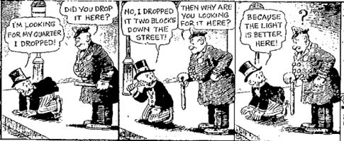
I had the honor of speaking on a UN panel with Hans Rosling in New York last year. During the Q&A, Hans showed Member States a map of cell phone coverage in the Democratic Republic of the Congo (DRC). The map was striking. Barely 10% of the country seemed to have coverage. This one map shut down the entire conversation about the value of mobile technology for data collection during disasters. Now, what Hans didn’t show was a map of the DRC’s population distribution, which reveals that the majority of the country’s population lives in urban areas; areas that have cell phone coverage. Hans’s map was also static and thus did not convey the fact that the number cell phone subscribers increased by roughly 50% in the year leading up to the panel and ~50% again the year after.
Of course, the number of social media users in the DRC is far, far lower than the country’s 12.4 million unique cell phone subscribers. The map below, for example, shows the location of Twitter users over a 10 day period in October 2013. Now keep in mind that only 2% of users actually geo-tag their tweets. Also, as my colleague Kalev Leetaru recently discovered, the correlation between the location of Twitter users and access to electricity is very high, which means that every place on Earth that is electrified has a high probability of having some level of Twitter activity. Furthermore, Twitter was only launched 7 years ago compared to the first cell phone, which was built 30 years ago. So these are still early days for Twitter. But that doesn’t change the fact that there is clearly very little Twitter traffic in the DRC today. And just like the man in the parable above, we only have access to answers where an “electrified tweet” exists (if we restrict ourselves to the Twitter streetlight).

But this begs the following question, which is almost always overlooked: too little traffic for what? This study by Harvard colleagues, for example, found that Twitter was faster (and as accurate) as official sources at detecting the start and early progress of Cholera after the 2010 earthquake. And yet, the corresponding Twitter map of Haiti does not show significantly more activity than the DRC map over the same 10-day period. Keep in mind there were far fewer Twitter users in Haiti four years ago (i.e., before the earthquake). Other researchers have recently shown that “micro-crises” can also be detected via Twitter even though said crises elicit very few tweets by definition. More on that here.

But why limit ourselves to the Twitter streetlight? Only a handful of “puzzle pieces” in our Haiti jigsaw may be tweets, but that doesn’t mean they can’t complement other pieces taken from traditional datasets and even other social media channels. Remember that there are five times more Facebook users than Twitter users. In certain contexts, however, social media may be of zero added value. I’ve reiterated this point again in recent talks at the Council on Foreign Relation and the UN. Social media is forming a new “nervous system” for our planet, but one that is still very young, even premature in places and certainly imperfect in representation. Then again, so was 911 in the 1970’s and 1980’s as explained here. In any event, focusing on more developed parts of the system (like Indonesia’s Twitter footprint below) makes more sense for some questions, as does complementing this new nervous system with other more mature data sources such mainstream media via as GDELT as advocated here.

The Twitter map of the Manila area below is also the result of 10-day traffic. While “only” ~12 million Filipinos (13% of the country) lives in Manila, it behoves us to remember that urban populations across the world are booming. In just over 2,000 days, more than half of the population in the world’s developing regions will be living in urban areas according to the UN. Meanwhile, the rural population of developing countries will decline by half-a-billion in coming decades. At the same time, these rural populations will also grow a larger social media footprint since mobile phone penetration rates already stand at 89% in developing countries according to the latest ITU study (PDF). With Google and Facebook making it their (for-profit) mission to connect those off the digital grid, it is only a matter of time until very rural communities get online and click on ads.

The radical increase in population density means that urban areas will become even more vulnerable to major disasters (hence the Rockefeller Foundation’s program on 100 Resilience Cities). To be sure, as Rousseau noted in a letter to Voltaire after the massive 1756 Portugal Earthquake, “an earthquake occurring in wilderness would not be important to society.” In other words, disaster risk is a function of population density. At the same time, however, a denser population also means more proverbial streetlights. But just as we don’t need a high density of streetlights to find our way at night, we hardly need everyone to be on social media for tweets and Instagram pictures to shed some light during disasters and facilitate self-organized disaster response at the grassroots level.

My good friend Jaroslav Valůch recounted a recent conversation he had with an old fireman in a very small town in Eastern Europe who had never heard of Twitter, Facebook or crowdsourcing. The old man said: “During crisis, for us, the firemen, it is like having a dark house where only some rooms are lit (i.e., information from mayors and other official local sources in villages and cities affected). What you do [with social media and crowdsourcing], is that you are lighting up more rooms for us. So don’t worry, it is enough.”
No doubt Hans Rosling will show another dramatic map if I happen to sit on another panel with him. But this time I’ll offer context so that instead of ending the discussion, his map will hopefully catalyze a more informed debate. In any event, I suspect (and hope that) Hans won’t be the only one objecting to my optimism in this blog post. So as always, I welcome feedback from iRevolution readers. And as my colleague Andrew Zolli is fond of reminding folks at PopTech:
“Be tough on ideas, gentle on people.”