
I visited the University of Torino in 2007 to speak with the team developing UAVs for the World Food Program. Since then, I’ve bought and tested two small UAVs of my own so I can use this new technology to capture aerial imagery during disasters; like the footage below from the Philippines.
UAVs, or drones, have a very strong military connotation for many of us. But so did space satellites before Google Earth brought satellite imagery into our homes and changed our perceptions of said technology. So it stands to reason that UAVs and aerial imagery will follow suit. This explains why I’m a proponent of the Drone Social Innovation Award, which seeks to promote the use of civilian drone technology for the benefit of humanity. I’m on the panel of judges for this award, which is why I reached out to DanOffice IT, a Swiss-based company that deployed two drones in response to Typhoon Yolanda in the Philippines. The drones in question are Huginn X1’s, which have a flight time of 25 minutes with a range of 2 kilometers and maximum altitude of 150 meters.
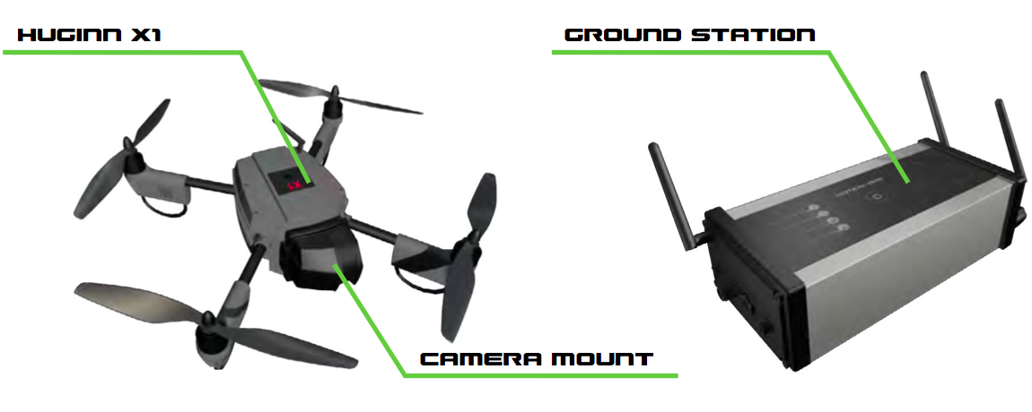
I recently spoke with one of the Huginn pilots who was in Tacloban. He flew the drone to survey shelter damage, identify blocked roads and search for bodies in the debris (using thermal imaging cameras mounted on the drone for the latter). The imagery captured also helped to identify appropriate locations to set up camp. When I asked the pilot whether he was surprised by anything during the operation, he noted that road-clearance support was not a use-case he had expected. I’ll be meeting with him in Switzerland in the next few weeks to test-fly a Huginn and explore possible partnerships.
I’d like to see closer collaboration between the Digital Humanitarian Network (DHN) and groups like DanOffice, for example. Providing DHN-member Humanitarian OpenStreetMap (HOTosm) with up-to-date aerial imagery during disasters would be a major win. This was the concept behind OpenAerialMap, which was first discussed back in 2007. While the initiative has yet to formally launch, PIX4D is a platform that “converts thousands of aerial images, taken by lightweight UAV or aircraft into geo-referenced 2D mosaics and 3D surface models and point clouds.”
This platform was used in Haiti with the above drones. The International Organization for Migration (IOM) partnered with Drone Adventures to map over 40 square kilometers of dense urban territory including several shantytowns in Port-au-Prince, which was “used to count the number of tents and organize a ‘door-to-door’ census of the population, the first step in identifying aid requirements and organizing more permanent infrastructure.” This approach could also be applied to IDP and refugee camps in the immediate aftermath of a sudden-onset disaster. All the data generated by Drone Adventures was made freely available through OpenStreetMap.
If you’re interested in giving “drones for social good” a try, I recommend looking at the DJI Phantom and the AR.Drone Parrot. These are priced between $300- $600, which beats the $50,000 price tag of the Huginn X1.


The use of drone aircraft for damage assessment has been one of the avenues explored by the Norman, Oklahoma chapter of the Red Cross, and a drone was used to a limited extent following the Moore tornado in May. One of the DA Managers there is a big proponent of using new technologies and techniques for assessment, including drones.
Our FIRST Lego League team (group of 6th-8th graders) has been exploring how to use sensors to detect gases and other hidden dangers. They’ve spoken with several emergency managers (including Moore, OK, first responders) who really love the idea and they are thinking about building a prototype now that they’ve identified several parts that could be used. It would probably be attached to a Raspberry Pi “brain” for a low-cost UAV add-on package. We made a short youtube presentation for a contest they entered about it here: https://www.youtube.com/watch?v=RoPsj9fj_lg
We’d love to hear your comments / suggestions!
This is a real example of a very great future. So now it is possible to deliver aid to disaster areas may be (drugs, vaccines, and more)
Reblogged this on Phd in Strategic Management.
Pingback: Using UAVs for Search & Rescue | iRevolution
Pingback: Using Crowd Computing to Analyze UAV Imagery for Search & Rescue Operations | iRevolution
Pingback: Launching a Search and Rescue Challenge for Drone / UAV Pilots | iRevolution
Pingback: Humanitarians Using UAVs for Post Disaster Recovery | iRevolution
Pingback: Welcome to the Humanitarian UAV Network | iRevolution
Pingback: An Operational Check-List for Flying UAVs in Humanitarian Settings | iRevolution
Pingback: An Introduction to Humanitarian UAVs and their Many Uses | iRevolution
Pingback: Debrief: UAV/Drone Search and Rescue Challenge | iRevolution
Pingback: Using MicroMappers to Make Sense of UAV Imagery During Disasters | iRevolution
Pingback: Humanitarian UAV Network: Strategy for 2014-2015 | iRevolution
Pingback: What Humanitarians Can Learn from Conservation UAVs | iRevolution
Pingback: Humanitarians in the sky | sUAS News
Pingback: Automatically Analyzing UAV/Aerial Imagery from Haiti | iRevolution
Pingback: The Use of Expendable UAVs After Typhoon Haiyan | iRevolution
Pingback: Evaluating UAVs for Humanitarian Response | iRevolution
Pingback: Crowdsourcing a Crisis Map of UAV/Aerial Videos for Disaster Response | iRevolution
Pingback: Comprehensive List of UAVs for Humanitarian Response | iRevolution
Pingback: Humanitarians in the Sky: Using UAVs for Disaster Response | iRevolution
Pingback: The Rise of the Humanitarian Drone: Giving Content to an Emerging Concept | iRevolution
Pingback: Drones for Development: Humanitarian Use Cases | InnovationAfrica
Pingback: Humanitarian UAVs Fly in China After Earthquake | iRevolution
Pingback: Official UN Policy Brief on Humanitarian UAVs | iRevolution