Category Archives: Crisis Mapping

Eyes on Darfur: 2 Villages Missing from Site

An update on Amnesty International’s (AI) “Eyes on Darfur” project based on my previous blog.

At least two of the protected villages monitored by AI using very-high resolution imagery provided by AAAS have been removed from the site after reported attacks in the area, with updated imagery still being processed. The attacks in question were summarized by this UNHCR Report.

This raises some important questions as noted by a colleague in a recent discussion: the bigger issue here is vital, all this geo-mapping is virtual, and while it may impact the real world that’s not a foregone conclusion; Would other NGOs, or perhaps a consortium, do better at the protective concept? And how? Namely, who can protect these villages and others like them?

I will write another blog this week on precisely these questions, i.e., civilian protection.

Patrick Philippe Meier

From Intellipedia, to Virtual Osocc to WikiWarning?

What can we in the humanitarian community learn from Intellipedia as described in my previous blog ?

Some thoughts:

  • Let go of our ego-centric tendencies for control
  • Decentralize user-generated content and access
  • Utilization of tagging, IM, online video posting
  • Use open source tools and make minimal modifications
  • Capture tacit and informal knowledge qualitatively via blogs and wikis
  • Keep user-interfaces simple and minimize use of sophisticated interfaces
  • Provide non-monetary incentives for information collection and sharing
  • Shift from quality control mindset to soap box approach

There are no doubt more insights to be gained from the Intellipedia project but do we have any parallel information management systems in the humanitarian community? The first one that comes to mind is Virtual Osocc:

There are currently 2,437 users. The site includes a bulletin board where discussions can take place vis-a-vis ongoing emergencies and/or issues. A photo library is also available as are sections on training and meetings. The site’s homepage points to breaking emergencies and ongoing crises. Users can subscribe to email and SMS alerts.

When I spoke with the team behind Virtual Osocc, I was surprised to learn that the project has received no official endorsement by any UN agencies. This is particularly telling since an indicator of success for humanitarian information systems is the size of the active user base. Other points worth mentioning from my conversations with the team since they relate directly to my previous blog on Intellipedia include:

  • Tensions between the UN and NGOs vis-vis information sharing is healthy since it keeps us honest;
  • Decision-making in disaster management is by consensus (so tools should be designed accordingly);
  • Our community is currently unable to communicate effectively with the beneficiaries themselves.

Another humanitarian information systems is of course ReliefWeb, which is very well known so I shan’t expand on the system here. I would just like to suggest that we think of ways to integrate more Web 2.0 tools into ReliefWeb; allowing a wiki and blogging space, for example. There’s also the Global Disaster Alert and Coordination System (GDACS) manged out of the Joint Research Center (JRC) in Ispra, Italy. See my recent blog on the JRC’s satellite imagery change detection project here. The JRC is doing some phenomenal work and GDACS is an excellent reflection of this work. I will leave a more thorough overview of GDACS for a future blog entry.

Then there’s the new information system which was launched this past October 2007 in collaboration with the JRC. The system is a new web portal for leading situation centers including those at UN DPKO, the EU Council and NATO. The purpose of the new system is to facilitate the exchange and storage of unique and relevant information on emerging and ongoing crises and conflicts.The portal facilitates the exchange of unique documents including satellite images. Users can subscribe to specific email and SMS alerts. The system also include a Wiki mapping section. Needless to say, the new web portal is password protected and the user base limited to an elite few. This initiative may benefit from more Intellipedia think.

The issue that I find most pressing in all of this is the lack of two-communication (not to mention one-way) communication with beneficiaries. I find this gap upsetting. So I set up Wikiwarning some two years ago in the hope of finding the time, support and expertise to fully develop the concept and tool. Any takers?

My next blog will address the issue of intelligence for the stakeholders.

Patrick Philippe Meier

UN World Food Program to use UAVs

I met with the World Food Program’s (WFP) Emergency Information Management team in Rome late last year and was pleasantly surprised when the term UAVs came up; Unmanned Areal Vehicles, otherwise known as drones and predators in different contexts. The fact that a leading field-based UN agency is actively engaged in a pilot program to use UAVs as early as this summer is particularly surprising and exciting at the same time.

Why surprising? UN Member States have been consistently touchy vis-a-vis issues of sovereignty. Indeed, much time has passed since President Dwight Eisenhower’s 1960 proposal for a “UN aerial reconnaissance capability […] to detect preparations for attack” to operate “in the territories of all nations prepared to accept such inspection.” Eisenhower had pledged that “the United States is prepared not only to accept United Nations aerial surveillance, but to do everything in its power to contribute to the rapid organization and successful operation of such international surveillance.” My, my how times have changed.

Why exciting? There is a notable albeit delayed “spill-over” effect between the use of ICTs by the disaster management and subsequently by the conflict prevention and human rights community. Furthermore, the occurrence of natural disasters amid complex political emergencies is an increasingly widespread phenomenon: over 140 natural disasters have occurred in complex political emergencies in the past five years alone.

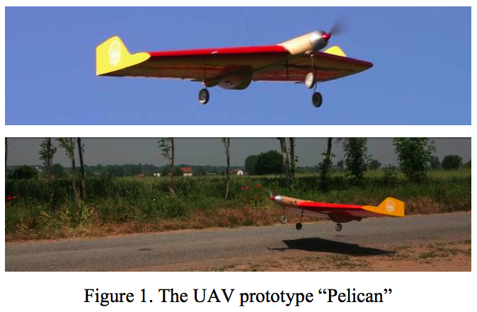
The team at WFP is collaborating with ITHACA to build the UAV prototype Pelican. ITHACA is the Information Technology for Humanitarian Assistance, Cooperation and Action, a center of Excellence created by Politecnico di Torino (DITAG) and the Istituto Superiore sui Sistemi Territoriali per l’Innovazione (Si.T.I)

The main goal of the UAV project is to support disaster management through an innovative and effective tool for rapid mapping purposes in the early impact stage. The UAV is easily transportable on normal aircrafts and usable on the field, autonomously, by a couple of operators. The platform is equipped with the autopilot MP2128g, which allows an autonomous flight except for take-off and landing, and with digital sensors characterized by geometric and radiometric resolutions suitable for digital photogrammetry. […]

If satellite data are not available or not suitable to supply radiometric and geometric information, in situ missions must be foresaw. To this end the Pelican is equipped with a GPS/IMU navigation system and different photographic sensors suitable for digital photogrammetric shootings with satisfying geometric and radiometric quality. It can be easily transportable on normal aircrafts and usable on the field by a couple of operators.

The aircraft is equipped with the MP2128g autopilot that allows autonomous flights and provides a real-time attitude of flight. The software HORIZONmp provides flight path and current sensor values in real-time. The operator can also insert a flight plan (up to 1000 waypoints) on a preloaded map and upload them during the flight. Besides the system can be connected with the payload cameras, so it is possible to schedule an automatic shooting time. The operations of take-off and landing must be accomplished manually due to the insufficient GPS’s in-flight accuracy.

The Pelican uses the Ricoh GR commercial digital camera. The use of two Ricohs (stereo pairs) allows the Pelican to rapidly update existing maps and to perform 3D feature extraction devoted to the identification of areas that require further investigations.

When I spoke to the team at WFP, they quoted a price range of $12-$10K, which is definitely the cheapest price tag I’ve come across for a UAV with the Pelican’s specs. The folks in Torino are also working to push the range of the Pelican to 200km with longer endurance limits. One could then operate the Pelican from Thailand/Burmese border and fly the UAV into Burma to identify movement of soldiers.

Of course, the military junta could try and take the bird down, but even if the small Pelican took a hit, all the data would have been captured before impact thanks to the real-time video downlink made possible by the Ricoh. The potential for an iRevolution would be met if video footage could be beamed to individual mobile phones, perhaps using the video encryption technology I recently blogged about.

Patrick Philippe Meier

UNHCR Refugee Google Earth Layer Released

UK Guardian: The new Google Earth layers weave together satellite maps, photos, videos and eyewitness accounts to give viewers a close-up look at the refugee crises in Iraq, Chad, Columbia and Darfur in Sudan.

They allow users to find out about UNHCR operations, locate refugee camps and discover the impact of the humanitarian crises on neighboring countries such as Sudan, Syria and Ecuador.

Users can explore the lives of those in exile by clicking on exact locations in the refugee camps to see photos of the facilities, such as health clinics, schools, water taps and sanitation. There are pop-up videos of specific operations and events, such as a visit to a Chad refugee camp by the actor and UN goodwill ambassador Angelina Jolie.

The UN deputy high commissioner for refugees, L Craig Johnstone, said: “Google Earth is a very powerful way for UNHCR to show the vital work that it is doing in some of the world’s most remote and difficult displacement situations. By showing our work in its geographical context, we can really highlight the challenges we face on the ground and how we tackle them.”

A UNHCR spokesman said the programme could soon develop further. “With the new generation of cameras with GPS, we can foresee taking photos of a place and uploading it directly to Google Earth. For our planning, mapping and communications unit, that would be an amazing tool.

“Over time, we can envision increasing the number of elements shown that will certainly increase the ‘live’ experience of the platform.”

The next step for an iRevolution is to enable refugees to access this information on a regular basis. This need not require high-technology. The information could be broadcast by radio, for example.

Patrick Philippe Meier

Google Earth: New VHR (Panopticon) Imagery

The Panopticon is now watching select locations in the Sudan, Chad and DRC at 2.5 meters resolution. The entire country of Zimbabwe is available at 2.5 meters. Below is satellite imagery for Harare and Umm Ruwabah.

Patrick Philippe Meier

Visualize African Connectivity

From ScienceDissemination:

This “Internet Weather”-like map shows the network performance measured from Trieste Italy to African Universities, from April 2007 to March 2008. Darker red dots indicate higher speeds such as enabled by ADSL or better. Clearer, lighter red dots indicate lower speeds, in some cases as poor as 56kbps modems. If a site is unreachable its dot disappears, so flickering dots indicate fragility. If all dots disappear the measurement host experienced an outage. Africa’s network performance is over 10 years behind that of Europe and the US and falling further behind. These measurements are made by the international PingER project and provide hard evidence of the extent of the Digital Divide for planners and policy makers. A high-quality version of this video is available upon request.

Patrick Philippe Meier

Human Rights 2.0: Eyes on Darfur

Amnesty International (AI) is taking human rights monitoring to a whole new level, metaphorically and literally speaking. The organization’s “Eyes on Darfur” project leverages the power of high-resolution satellite imagery to provide unimpeachable evidence of the atrocities being committed in Darfur – enabling action by private citizens, policy makers and international courts. Eyes On Darfur also breaks new ground in protecting human rights by allowing people around the world to literally “watch over” and protect twelve intact, but highly vulnerable, villages using commercially available satellite imagery.

I met with AI today to learn more. The human rights organization sends government officials these images on a regular basis to remind them that the world is watching. The impact? The villages monitored by AI have not been attacked while neighboring ones have. According to AI, there have also been notable changes in decisions made by the Bashir government since “Eyes on Darfur” went live a year ago. Equally interesting is that AI has been able to track the movement of the Janjaweed thanks to commercially available satellite imagery. In addition, the government of Chad cited the AI project as one of the reasons they accepted UN peacekeepers.

The American Association for the Advancement of Science (AAAS) is also leading a Human Rights and Geospatial Technologies project. So I also sat with them to learn more (September 2007). NGOs in Burma provided AAAS with information concerning attacks on civilians carried out by government forces in late 2006 and early 2007. AAAS staff reviewed these reports and compared them with high-resolution satellite images to identify destruction of housing and infrastructure and construction of new military occupation camps. The result is available in these Google Earth Layers. AAAS has provided comparable layers for Sudan, Chad, Lebanon and Zimbabwe. And this is just the tip of the iceberg.

AI is venturing on a 3-year project to provide satellite imagery to monitor forced displacement for early detection and advocacy. AAAS is developing a user-friendly web-based interface to let the NGO community know in real time where commercial satellites are positioned and what geographical areas they are taking pictures of. The interface includes direct links to the private companies operating these satellites along with contact and pricing information. AAAS believes this tool will enable the NGO community to make far more effective use of satellite imagery and to serve as a deterrent against repressive regimes choosing to commit mass atrocities.

The European Commission’s Joint Research Center (JRC) out of Ispra, Italy is also engaged in phenomenal work using satellite imagery. I first met with the JRC in 2004 and more recently in October 2007. The Center has developed automated models for change detection that are far more reliable than previously thought possible. Using pattern detection algorithms, the JRC can detect whether infrastructure has been destroyed, damaged, built or remained unchanged. They are now applying these models to monitor changes in refugee camps worldwide. The advantage of the JRC’s models is that they don’t necessarily require high resolution satellite imagery.

The same team at the JRC has also developed models to approximate population density in urban areas such as the Kibera slums out of Nairobi. Using satellite pictures taken at different angles, the team is able to construct 3D models of infrastructure such as individual buildings and houses. Thanks to these models they are able to approximate the size of these structures and thus estimate the number of inhabitants.

While AI and AAAS have been collaborating on some of these projects, the JRC has not been connected to this work. I therefore organized a working lunch during the OCHA +5 Symposium in Geneva last Fall to connect AAAS, the JRC, the Feinstein Center and the USHMM. My intention is to catalyze greater collaboration between these organizations and projects so we can upgrade to Human Rights 2.0.

Patrick Philippe Meier