There are over half-a-billion Twitter users, with an average of 135,000 new users signing up on a daily basis (1). Can emergency management and disaster response organizations win over some Twitter users by convincing them to use their apps in addition to Twitter? For example, will FEMA’s smartphone app gain as much “market share”? The app’s new crowdsourcing feature, “Disaster Reporter,” allows users to submit geo-tagged disaster-related images, which are then added to a public crisis map. So the question is, will more images be captured via FEMA’s app or from Twitter users posting Instagram pictures?
This question is perhaps poorly stated. While FEMA may not get millions of users to share disaster-related pictures via their app, it is absolutely critical for disaster response organizations to explicitly solicit crisis information from the crowd. See my blog post “Social Media for Emergency Management: Question of Supply and Demand” for more information on the importance demand-driven crowdsourcing. The advantage of soliciting crisis information from a smartphone app is that the sourced information is structured and thus easily machine readable. For example, the pictures taken with FEMA’s app are automatically geo-tagged, which means they can be automatically mapped if need be.
While many, many more picture may be posted on Twitter, these may be more difficult to map. The vast majority of tweets are not geo-tagged, which means more sophisticated computational solutions are necessary. Instagram pictures are geo-tagged, but this information is not publicly available. So smartphone apps are a good way to overcome these challenges. But we shouldn’t overlook the value of pictures shared on Twitter. Many can be geo-tagged, as demonstrated by the Digital Humanitarian Network’s efforts in response to Typhoon Pablo. More-over, about 40% of pictures shared on Twitter in the immediate aftermath of the Oklahoma Tornado had geographic data. In other words, while the FEMA app may have 10,000 users who submit a picture during a disaster, Twitter may have 100,000 users posting pictures. And while only 40% of the latter pictures may be geo-tagged, this would still mean 40,000 pictures compared to FEMA’s 10,000. Recall that over half-a-million Instagram pictures were posted during Hurricane Sandy alone.
The main point, however, is that FEMA could also solicit pictures via Twitter and ask eyewitnesses to simply geo-tag their tweets during disasters. They could also speak with Instagram and perhaps ask them to share geo-tag data for solicited images. These strategies would render tweets and pictures machine-readable and thus automatically mappable, just like the pictures coming from FEMA’s app. In sum, the key issue here is one of policy and the best solution is to leverage multiple platforms to crowdsource crisis information. The technical challenge is how to deal with the high volume of pictures shared in real-time across multiple platforms. This is where microtasking comes in and why MicroMappers is being developed. For tweets and images that do not contain automatically geo-tagged data, MicroMappers has a microtasking app specifically developed to crowd-source the manual tagging of images.
In sum, there are trade-offs. The good news is that we don’t have to choose one solution over the other; they are complementary. We can leverage both a dedicated smartphone app and very popular social media platforms like Twitter and Facebook to crowdsource the collection of crisis information. Either way, a demand-driven approach to soliciting relevant information will work best, both for smartphone apps and social media platforms.
Disaster response apps have multiplied in recent years. I’ve been reviewing the most promising ones and have found that many cater to professional responders and organizations. While empowering paid professionals is a must, there has been little focus on empowering the real first responders, i.e., the disaster-affected communities themselves. To this end, there is always a dramatic mismatch in demand for responder services versus supply, which is why crises are brutal audits for humanitarian organizations. Take this Red Cross survey, which found that 74% of people who post a need on social media during a disaster expect a response within an hour. But paid responders cannot be everywhere at the same time during a disaster. The response needs to be decentralized and crowdsourced.
In contrast to paid responders, the crowd is always there. And most survivals following a disaster are thanks to local volunteers and resources, not external aid or relief. This explains why FEMA Administrator Craig Fugate has called on the public to become a member of the team. Decentralization is probably the only way for emergency response organizations to improve their disaster audits. As many seasoned humanitarian colleagues of mine have noted over the years, the majority of needs that materialize during (and after) a disaster do not require the attention of paid disaster responders with an advanced degree in humanitarian relief and 10 years of experience in Haiti. We are not all affected in the same way when disaster strikes, and those less affected are often very motivated and capable at responding to the basic needs of those around them. After all, the real first responders are—and have always been—the local communities themselves, not the Search and Rescue Teams that parachutes in 36 hours later.
In other words, local self-organized action is a natural response to disasters. Facilitated by social capital, self-organized action can accelerate both response & recovery. A resilient community is therefore one with ample capacity for self-organization. To be sure, if a neighborhood can rapidly identify local needs and quickly match these with available resources, they’ll rebound more quickly than those areas with less capacity for self-organized action. The process is a bit like building a large jigsaw puzzle, with some pieces standing for needs and others for resources. Unlike an actual jigsaw puzzle, however, there can be hundreds of thousands of pieces and very limited time to put them together correctly.
This explains why I’ve long been calling for a check-in & match.com smartphone app for local collective disaster response. The talk I gave (above) at Where 2.0 in 2011 highlights this further as do the blog posts below.
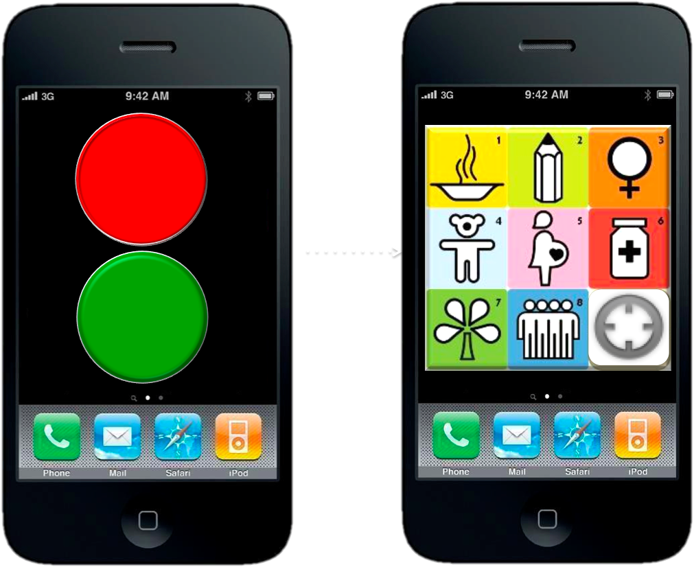
This “MatchApp” could rapidly match hyper local needs with resources (material & informational) available locally or regionally. Check-in’s (think Foursquare) can provide an invaluable function during disasters. We’re all familiar with the command “In case of emergency break glass,” but what if: “In case of emergency, then check-in”? Checking-in is space- and time-dependent. By checking in, I announce that I am at a given location at a specific time with a certain need (red button). This means that information relevant to my location, time, user-profile (and even vital statistics) can be customized and automatically pushed to my MatchApp in real-time. After tapping on red, MatchApp prompts the user to select what specific need s/he has. (Yes, the icons I’m using are from the MDGs and just placeholders). Note that the App we’re building is for Androids, not iPhones, so the below is for demonstration purposes only.
But MatchApp will also enable users who are less (or not) affected by a disaster to check-in and offer help (by tapping the green button). This is where the match-making algorithm comes to play. There are various (compatible options) in this respect. The first, and simplest, is to use a greedy algorithm. This algorithm select the very first match available (which may not be the most optimal one in terms of location). A more sophisticated approach is to optimize for the best possible match (which is a non-trivial challenge in advanced computing). As I’m a big fan of Means of Exchange, which I have blogged about here, MatchApp would also enable the exchange of goods via bartering–a mobile eBay for mutual-help during disasters.
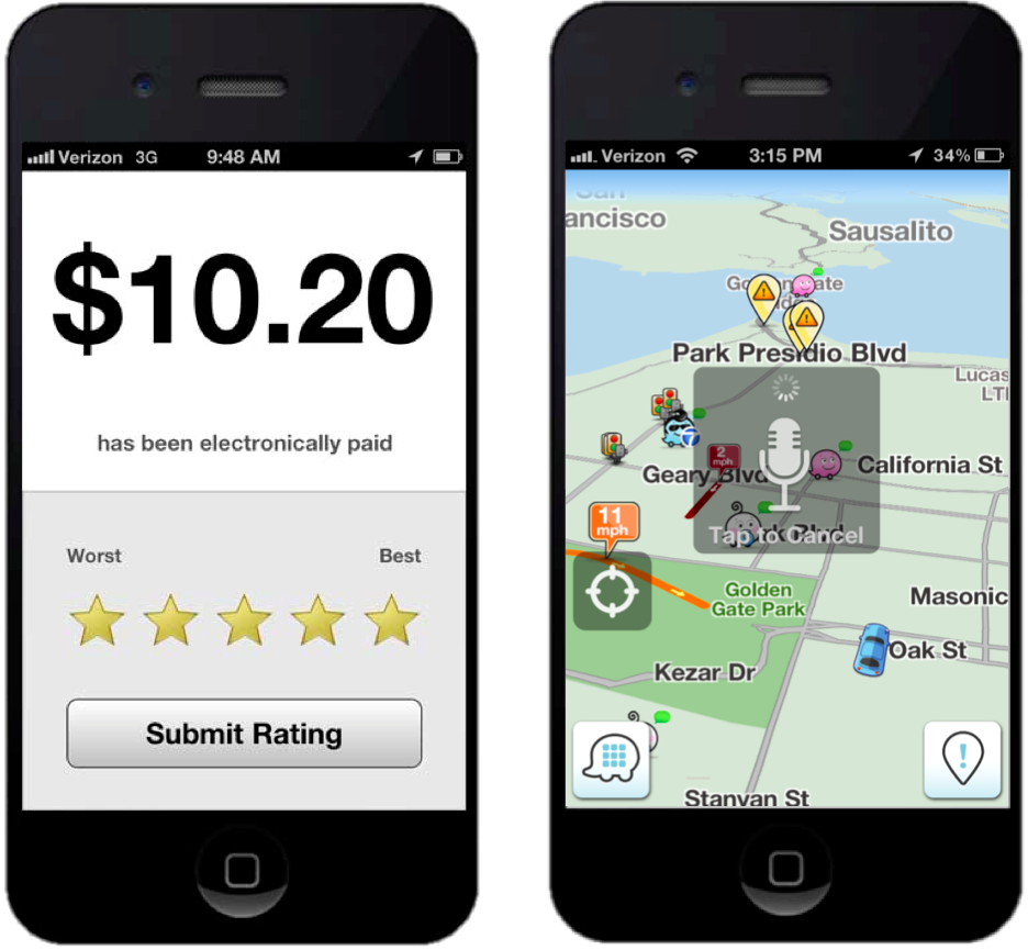
Once a match is made, the two individuals in question receive an automated alert notifying them about the match. By default, both users’ identities and exact locations are kept confidential while they initiate contact via the app’s instant messaging (IM) feature. Each user can decide to reveal their identity/location at any time. The IM feature thus enables users to confirm that the match is indeed correct and/or still current. It is then up to the user requesting help to share her or his location if they feel comfortable doing so. Once the match has been responded to, the user who received help is invited to rate the individual who offered help (and vice versa, just like the Uber app, depicted on the left below).
As a next generation disaster response app, MatchApp would include a number of additional data entry features. For example, users could upload geo-tagged pictures and video footage (often useful for damage assessments). In terms of data consumption and user-interface design, MatchApp would be modeled along the lines of the Waze crowdsourcing app (depicted on the right above) and thus designed to work mostly “hands-free” thanks to a voice-based interface. (It would also automatically sync up with Google Glasses).
In terms of verifying check-in’s and content submitted via MatchApp, I’m a big fan of InformaCam and would thus integrate the latter’s meta-data verification features into MatchApp: “the user’s current GPS coordinates, altitude, compass bearing, light meter readings, the signatures of neighboring devices, cell towers, and wifi networks; and serves to shed light on the exact circumstances and contexts under which the digital image was taken.” I’ve also long been interested in peer-to-peer meshed mobile communication solutions and would thus want to see an integration with the Splinternet app, perhaps. This would do away with the need for using cell phone towers should these be damaged following a disaster. Finally, MatchApp would include an agile dispatch-and-coordination feature to allow “Super Users” to connect and coordinate multiple volunteers at one time in response to one or more needs.
In conclusion, privacy and security are a central issue for all smartphone apps that share the features described above. This explains why reviewing the security solutions implemented by multiple dating websites (especially those dating services with a strong mobile component like the actual Match.com app) is paramount. In addition, reviewing security measures taken by Couchsurfing, AirBnB and online classified adds such as Craig’s List is a must. There is also an important role for policy to play here: users who submit false misinformation to MatchApp could be held accountable and prosecuted. Finally, MatchApp would be free and open source, with a hyper-customizable, drag-and-drop front- and back-end.
I thrive when working across disciplines, building diverse cross-cutting coalitions to create, translate and apply innovative strategies driven by shared values. This has enabled the 20+ organizations I’ve worked with, and those I’ve led, to accelerate meaningful and inclusive social impact.
Which is why I've been called a social entrepreneur and a translational leader by successful innovators. President Clinton once called me a digital pioneer, while recent colleagues describe me as kind, dedicated, values-driven, authentic, creative, ethical, and impactful.