Tag Archives: Technology

On Humanitarian Innovation versus Robotic Natives

I recently read an excellent piece entitled “Humanitarian Innovation and the Art of the Possible,” which appeared in the latest issue of the Humanitarian Practice Network’s (HPN) magazine. The author warns that humanitarian innovation will have limited systemic impact unless there is notable shift in the culture and underlying politics of the aid system. Turns out I had written a similar piece (although not nearly as articulate) during the first year of my PhD in 2005. I had, at the time, just re-read Alex de Waal’s Famine Crimes: Politics and the Disaster Relief Industry in Africa and Peter Uvin’s Aiding Violence.

thumb_IMG_5014_1024

Kim Scriven, the author of the HPN piece and one of the leading thinkers in the humanitarian innovation space, questions whether innovation efforts are truly “free from the political and institutional blockages curtailing other initiatives” in the humanitarian space. He no doubt relates to “field-based humanitarians who have looked on incredulously as technological quick fixes are deployed from afar to combat essentially political blockages to the provision of aid.” This got me thinking about the now well-accepted notion that information is aid.

What kinds of political blockages exist vis-a-vis the provision of information (communication) during or after humanitarian crises? “For example,” writes Kim, “the adoption of new technology like SMS messaging may help close the gap between aid giver and aid recipient, but it will not be sufficient to ensure that aid givers respond to the views and wishes of affected people.” One paragraph later, Kim warns that we must also “look beyond stated benefits [of innovation] to unintended consequences, for instance around how the growing use of drones and remote communication technologies in the humanitarian sphere may be contributing to the increased use of remote management practices, increasing the separation between agencies and those they seek to assist.”

I find this all very intriguing for several reasons. First, the concern regarding the separation—taken to be the physical distance—between agencies and those they seek to assist is an age-old concern. I first came across said concern while at the Harvard Humanitarian Initiative (HHI) in 2007. At the time, ironically, it was the use of SMS in humanitarian and development projects that provoked separation anxiety amongst aid groups. By 2012, humanitarian organizations were starting to fear that social media would further increase the separation. But as we’ve said, communication is aid, and unlike food and medication, digital information doesn’t need to hitch a ride on UN planes and convoys to reach their destination. Furthermore, studies in social psychology have shown that access to timely information during crises can reduce stress, anxiety and despair. So now, in 2016, it seems to be the turn of drones; surely this emerging technology will finally create the separation anxiety that some humanitarians have long-feared (more on this in a bit).

The second reason I find Kim’s points intriguing is because of all the talk around the importance of two-way communication with disaster-affected communities. Take the dire refugee crisis in Europe. When Syrians finally escape the horrid violence in their country and make it alive to Europe, their first question is: “Where am I?” and their second: “Do you have WiFi?” In other words, they want to use their smartphones to communicate & access digital information precisely because mobile technology allows for remote communication and access.

Young humanitarian professionals understand this; they too are Digital Natives. If crisis-affected communities prefer to communicate using mobile phones, then is it not the duty of humanitarian organizations to adapt and use those digital communication channels rather than force their analog channels on others? The priority here shouldn’t be about us and our preferences. But is there a political economy—an entrenched humanitarian industrial complex—that would prefer business as usual since innovation could disrupt existing funding channels? Could these be some of the political & institutional blockages that Kim hints at?

The third reason is the reference to drones. Kim warns that the “growing use of drones and remote communication technologies in the humanitarian sphere may be contributing to the increased use of remote management practices, increasing the separation between agencies and those they seek to assist.” Ironically, the same HPN magazine issue that Kim’s piece appears in also features this article on “Automation for the People: Opportunities and Challenges of Humanitarian Robotics,” co-authored by Dr. Andrew Schroeder & myself. Incidentally, drones (also as UAVs) are aerial robots.

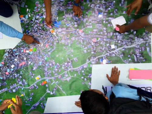
Kim kindly provided Andrew and I with valuable feedback on earlier drafts. So he is familiar with the Humanitarian UAV Code of Conduct and its focus on Community Engagement since we delve into this in our HPN piece. In fact, the header image featured in Kim’s article (also displayed above) is a photograph I took whilst in Nepal; showing local community members using a map created with aerial robots as part of a damage assessment exercise. Clearly, the resulting map did not create physical separation—quite on the contrary, it brought the community and robotics operators together as has happened in Haiti, Tanzania, the Philippines and elsewhere.

(As an aside, a number of UAV teams in Ecuador used the Code of Conduct in their response efforts, more here. Also, I’m co-organizing an Experts Meeting in the UK this June that will, amongst other deliverables, extend said code of conduct to include the use of aerial robotics for cargo transportation).

What’s more, Andrew and I used our article for HPN to advocate for locally managed and operated robotics solutions enabled through local innovation labs (Flying Labs) to empower local responders. In other words, and to quote Kim’s own concluding paragraph, we agree that “those who focus on innovation must do a better job of relocating innovation capacity from HQ to the field, providing tools and guidance to support those seeking to solve problems in the delivery of aid.” Hence, in part, the Flying Labs.

In fact, we’ve already started co-creating Kathmandu Flying Labs, and thanks to both the relevant training and the appropriate robotics technologies that we transferred to members of Kathmandu Flying Labs following the devastating earthquakes in 2015, one of these partners—Kathmandu University—have since carried out multiple damage assessments using aerial robotics; without needing any assistance from us or needing our permission for that matter. The Labs are also about letting go of control, and deliberately so. Which projects Kathmandu Flying Labs partners decide to pursue with their new aerial robotics platforms is entirely their decision, not ours. Trust is key. Besides, the Flying Labs are not only about providing access to appropriate robotics solutions and relevant skills, they are just as much about helping to connect & turbocharge the local capacity for innovation that already exists, and disseminating that innovation globally.

Kathmandu University’s damage assessments didn’t create a separation between themselves and the local communities. KU followed the UAV Code of Conduct and worked directly with local communities throughout. So there is nothing inherent to robotics as a technology that innately creates the separation that Kim refers to. Nor is there anything inherent to robotics that will ensure that aid givers (or robots) respond to the needs of disaster-affected communities. This is also true of SMS as Kim points out above. Technology is just a tool; how we chose to use technology is a human decision.

The fourth and final reason I find Kim’s piece intriguing is because it suggests that remote management practices and physical separations between agencies and those they seek to assist are to be avoided. But the fact of the matter is that remote management is sometimes the most efficient solution; in some cases, it is the only solution, as clearly evidenced in the protracted response to the complex humanitarian crisis in Syria. In fact, the United Nation’s Inter-Agency Standing Committee (IASC) suggests bolstering remote management in some cases. And besides, the vast majority of humanitarian interventions engage in some level of remote management.

So if we can use aerial robotics to deliver essential supplies more quickly, more reliably and at lower cost (like in Rwanda), then how exactly does using fewer motorbikes or trucks to deliver said supplies create more separation between agencies and those they seek to assist? In the case of Rwanda, aerial robotics solutions are airlifting much-needed blood supplies to remote health clinics across the country. I’d like to know how exactly this creates a separation between the doctors administering the blood transfusion and the patients receiving said transfusion. As for using aerial robotics solutions to collect data, we’ve already shown that community engagement is key and that local partners can expertly manage the operation of robotics platforms independently. The most obvious alternative to aerial imagery is satellite imagery, but orbiting satellites certainly don’t allow local partners and communities to participate in data collection.

So are there “political and institutional blockages” against the use of robotics in humanitarian efforts? Might humanitarian organizations receive less funding if aerial robotics solutions prove to be cheaper, more effective and more scalable? Is this one reason, to quote Kim, that “Emerging ideas get stuck at the pilot stage or siloed within a single organization unable to achieve scale and impact”? Are political & institutional barriers curtailing in part the entry of new and radically more efficient solutions to deliver aid? If these autonomous solutions require less international staff to manually operate, will the underlying politics of the $25 billion dollar-a-year aid industry allow such a shift? Or will it revert to fears over (money) separation anxiety?

We should realize that disaster-affected communities today are increasingly digital communities. As such, Digital Natives do not necessarily share the physical separation anxieties that aid organizations seemingly experience with every new emerging technology. Digital Natives, by definition, prefer a friction-free world. But by the time we catch on, we’ll no doubt struggle to understand the newer world of Robotic Natives. We’ll look on incredulously as the new generation of Robotic and AI Natives prefer to interact with Facebook chatbots over “analog humanitarians” during disasters. Some of us may cry foul when Robotic Natives decide to get their urgent 3D-printed food supplies delivered to them via aerial robotics while riding a driverless robotics car to their auto-matically built-in-time shelter.

In conclusion, yes, we should of course be aware and weary of the unintended consequences that new innovations in technology may have when employed in humanitarian settings. Has anyone ever suggested the contrary? At the same time, we should realize that those same unintended consequences may in some cases be welcomed or even preferred over the status quo, especially by Robotic Natives. In other words, those unintended effects may not always be a bug, but rather a feature. Whether these consequences are viewed as a bug or a feature is ultimately a political decision. And whether or not the culture and underlying politics of the aid system will shift to accommodate the new bug as-a-feature worldview, we may be deluding ourselves if we think we can change the world-view of Robotics Natives to accommodate our culture and politics. Such is the nature of innovation and systemic impact.

Evaluating UAVs for Humanitarian Response

The Humanitarian UAV Network is carrying out an evaluation of UAVs and related technologies for use in humanitarian settings. The related technologies being evaluated include cameras, payload units, image processing & analysis software. As a first step, we have created an evaluation framework based on parameters relevant for field-based deployments of UAVs by humanitarian organizations. Before moving to the next step in the evaluation—identifying which UAVs and related technologies to evaluate—we want to make sure that we’re on the right track as far as our evaluation framework goes. So the purpose of this blog post is to seek feedback on said framework.

UAViators Logo

To recap, we are evaluating four distinct technologies: 1) UAVs; 2) Cameras; 3) Payload units; and 4) Image Processing & Analysis Software specifically for humanitarian use. So below are the evaluation criteria we have identified for each technology.

UAVs: Type, Cost, Size, Weight, Appearance, Noise Factor, Durability, Ease of Use, Ease of Repair, Payload Capacity, Flight Time, Transmitter Range,  Autonomy, Camera/Gimbal Compatibility and Legality/Customs.

Most of the parameters are self-explanatory but a few require some elaboration. Type refers to whether the UAV is a fixed-wing, rotary-wing or a hybrid. Appearance seeks to evaluate whether the UAV airframe looks threatening or more like a toy, for example. Autonomy refers to whether the UAV can be flown autonomously. Legality/Customs seeks to assess whether the transportation of the UAV across borders is likely to be easy or challenging.

Cameras: Cost, Size, Weight, Megapixels, Memory, Control, Durability, Easy of Use, Ease of Repair, Lens Type and Gimbal Compatibility.

Payload Units: Cost, Size, Weight, Type of Release Mechanism, Release Mechanism, Ease of Use and Ease of Repair.

Image Software: Cost, Image Processing, Image Analysis, Ease of Use, System Requirements, Compatibility and Type of License.

We need to make sure that we fill any gaps in our evaluation criteria before proceeding with the assessment. So what parameters are we missing?

bio

See Also:

  • Welcome to the Humanitarian UAV Network [link]
  • How UAVs are Making a Difference in Disaster Response [link]
  • Humanitarians Using UAVs for Post Disaster Recovery [link]
  • Grassroots UAVs for Disaster Response [link]
  • Using UAVs for Search & Rescue [link]
  • Debrief: UAV/Drone Search & Rescue Challenge [link]
  • Crowdsourcing Analysis of UAV Imagery for Search/Rescue [link]
  • Check-List for Flying UAVs in Humanitarian Settings [link]


Crisis Mapping in Areas of Limited Statehood

I had the great pleasure of contributing a chapter to this new book recently published by Oxford University Press: Bits and Atoms: Information and Communication Technology in Areas of Limited Statehood. My chapter addresses the application of crisis mapping to areas of limited statehood, drawing both on theory and hands-on experience. The short introduction to my chapter is provided below to help promote and disseminate the book.

Collection-national-flags

Introduction

Crises often challenge or limit statehood and the delivery of government services. The concept of “limited statehood” thus allows for a more realistic description of the territorial and temporal variations of governance and service delivery. Total statehood, in any case, is mostly imagined—a cognitive frame or pre-structured worldview. In a sense, all states are “spatially challenged” in that the projection of their governance is hardly enforceable beyond a certain geographic area and period of time. But “limited statehood” does not imply the absence of governance or services. Rather, these may simply take on alternate forms, involving procedures that are non-institutional (see Chapter 1). Therein lies the tension vis-à-vis crises, since “the utopian, immanent, and continually frustrated goal of the modern state is to reduce the chaotic, disorderly, constantly changing social reality beneath it to something more closely resembling the administrative grid of its observations” (Scott 1998). Crises, by definition, publicly disrupt these orderly administrative constructs. They are brutal audits of governance structures, and the consequences can be lethal for state continuity. Recall the serious disaster response failures that occurred following the devastating cyclone of 1970 in East Pakistan.

To this day, Cyclone Bhola still remains the most deadly cyclone on record, killing some 500,000 people. The lack of timely and coordinated government response was one of the triggers for the war of independence that resulted in the creation of Bangladesh (Kelman 2007). While crises can challenge statehood, they also lead to collective, self-help behavior among disaster-affected communities—particularly in areas of limited statehood. Recently, this collective action—facilitated by new information and communication technologies—has swelled and resulted in the production of live crisis maps that identify the disaggregated, raw impact of a given crisis along with resulting needs for services typically provided by the government (see Chapter  7). These crisis maps are sub-national and are often crowdsourced in near real-time. They empirically reveal the limited contours of governance and reframe how power is both perceived and projected (see Chapter 8).

Indeed, while these live maps outline the hollows of governance during times of upheaval, they also depict the full agency and public expression of citizens who self-organize online and offline to fill these troughs with alternative, parallel forms of services and thus governance. This self-organization and public expression also generate social capital between citizen volunteers—weak and strong ties that nurture social capital and facilitate future collective action both on and offline.

The purpose of this chapter is to analyze how the rise of citizen-generated crisis maps replaces governance in areas of limited statehood and to distill the conditions for their success. Unlike other chapters in this book, the analysis below focuses on a variable that has been completely ignored in the literature:  digital social capital. The chapter is thus structured as follows. The first section provides a brief introduction to crisis mapping and frames this overview using James Scott’s discourse from Seeing Like a State (1998). The next section briefly highlights examples of crisis maps in action—specifically those responding to natural disasters, political crises, and contested elections. The third section provides a broad comparative analysis of these case studies, while the fourth section draws on the findings of this analysis to produce a list of ingredients that are likely to render crowdsourced crisis-mapping more successful in areas of limited statehood. These ingredients turn out to be factors that nurture and thrive on digital social capital such as trust, social inclusion, and collective action. These drivers need to be studied and monitored as conditions for successful crisis maps and as measures of successful outcomes of online digital collaboration. In sum, digital crisis maps both reflect and change social capital.

Bio

MatchApp: Next Generation Disaster Response App?

Disaster response apps have multiplied in recent years. I’ve been  reviewing the most promising ones and have found that many cater to  professional responders and organizations. While empowering paid professionals is a must, there has been little focus on empowering the real first responders, i.e., the disaster-affected communities themselves. To this end, there is always a dramatic mismatch in demand for responder services versus supply, which is why crises are brutal audits for humanitarian organizations. Take this Red Cross survey, which found that 74% of people who post a need on social media during a disaster expect a response within an hour. But paid responders cannot be everywhere at the same time during a disaster. The response needs to be decentralized and crowdsourced.

Screen Shot 2013-02-27 at 4.08.03 PM

In contrast to paid responders, the crowd is always there. And most survivals following a disaster are thanks to local volunteers and resources, not external aid or relief. This explains why FEMA Administrator Craig Fugate has called on the public to become a member of the team. Decentralization is probably the only way for emergency response organizations to improve their disaster audits. As many seasoned humanitarian colleagues of mine have noted over the years, the majority of needs that materialize during (and after) a disaster do not require the attention of paid disaster responders with an advanced degree in humanitarian relief and 10 years of experience in Haiti. We are not all affected in the same way when disaster strikes, and those less affected are often very motivated and capable at responding to the basic needs of those around them. After all, the real first responders are—and have always been—the local communities themselves, not the Search and Rescue Teams that parachutes in 36 hours later.

In other words, local self-organized action is a natural response to disasters. Facilitated by social capital, self-organized action can accelerate both response & recovery. A resilient community is therefore one with ample capacity for self-organization. To be sure, if a neighborhood can rapidly identify local needs and quickly match these with available resources, they’ll rebound more quickly than those areas with less capacity for self-organized action. The process is a bit like building a large jigsaw puzzle, with some pieces standing for needs and others for resources. Unlike an actual jigsaw puzzle, however, there can be hundreds of thousands of pieces and very limited time to put them together correctly.

This explains why I’ve long been calling for a check-in & match.com smartphone app for local collective disaster response. The talk I gave (above) at Where 2.0 in 2011 highlights this further as do the blog posts below.

Check-In’s with a Purpose: Applications for Disaster Response
http://iRevolution.net/2011/02/16/checkins-for-disaster-response

Maps, Activism & Technology: Check-In’s with a Purpose
http://iRevolution.net/2011/02/05/check-ins-with-a-purpose

Why Geo-Fencing Will Revolutionize Crisis Mapping
http://iRevolution.net/2011/08/21/geo-fencing-crisis-mapping

How to Crowdsource Crisis Response
http://iRevolution.net/2011/09/14/crowdsource-crisis-response

The Crowd is Always There
http://iRevolution.net/2010/08/14/crowd-is-always-there

Why Crowdsourcing and Crowdfeeding may be the Answer
http://iRevolution.net/2010/12/29/crowdsourcing-crowdfeeding

Towards a Match.com for Economic Resilience
http://iRevolution.net/2012/07/04/match-com-for-economic-resilience

This “MatchApp” could rapidly match hyper local needs with resources (material & informational) available locally or regionally. Check-in’s (think Foursquare) can provide an invaluable function during disasters. We’re all familiar with the command “In case of emergency break glass,” but what if: “In case of emergency, then check-in”? Checking-in is space- and time-dependent. By checking in, I announce that I am at a given location at a specific time with a certain need (red button). This means that information relevant to my location, time, user-profile (and even vital statistics) can be customized and automatically pushed to my MatchApp in real-time. After tapping on red, MatchApp prompts the user to select what specific need s/he has. (Yes, the icons I’m using are from the MDGs and just placeholders). Note that the App we’re building is for Androids, not iPhones, so the below is for demonstration purposes only.

Screen Shot 2013-02-27 at 3.32.29 PM

But MatchApp will also enable users who are less (or not) affected by a disaster to check-in and offer help (by tapping the green button). This is where the match-making algorithm comes to play. There are various (compatible options) in this respect. The first, and simplest, is to use a greedy algorithm. This  algorithm select the very first match available (which may not be the most optimal one in terms of location). A more sophisticated approach is to optimize for the best possible match (which is a non-trivial challenge in advanced computing). As I’m a big fan of Means of Exchange, which I have blogged about here, MatchApp would also enable the exchange of goods via bartering–a mobile eBay for mutual-help during disasters.

Screen Shot 2013-02-27 at 3.34.17 PM

Once a match is made, the two individuals in question receive an automated alert notifying them about the match. By default, both users’ identities and exact locations are kept confidential while they initiate contact via the app’s instant messaging (IM) feature. Each user can decide to reveal their identity/location at any time. The IM feature thus enables  users to confirm that the match is indeed correct and/or still current. It is then up to the user requesting help to share her or his location if they feel comfortable doing so. Once the match has been responded to, the user who received help is invited to rate the individual who offered help (and vice versa, just like the Uber app, depicted on the left below).

Screen Shot 2013-02-27 at 3.49.04 PM

As a next generation disaster response app, MatchApp would include a number of additional data entry features. For example, users could upload geo-tagged pictures and video footage (often useful for damage assessments).  In terms of data consumption and user-interface design,  MatchApp would be modeled along the lines of the Waze crowdsourcing app (depicted on the right above) and thus designed to work mostly “hands-free” thanks to a voice-based interface. (It would also automatically sync up with Google Glasses).

In terms of verifying check-in’s and content submitted via MatchApp, I’m a big fan of InformaCam and would thus integrate the latter’s meta-data verification features into MatchApp: “the user’s current GPS coordinates, altitude, compass bearing, light meter readings, the signatures of neighboring devices, cell towers, and wifi networks; and serves to shed light on the exact circumstances and contexts under which the digital image was taken.” I’ve also long been interested in peer-to-peer meshed mobile communication solutions and would thus want to see an integration with the Splinternet app, perhaps. This would do away with the need for using cell phone towers should these be damaged following a disaster. Finally, MatchApp would include an agile dispatch-and-coordination feature to allow “Super Users” to connect and coordinate multiple volunteers at one time in response to one or more needs.

In conclusion, privacy and security are a central issue for all smartphone apps that share the features described above. This explains why reviewing the security solutions implemented by multiple dating websites (especially those dating services with a strong mobile component like the actual Match.com app) is paramount. In addition, reviewing  security measures taken by Couchsurfing, AirBnB and online classified adds such as Craig’s List is a must. There is also an important role for policy to play here: users who submit false misinformation to MatchApp could be held accountable and prosecuted. Finally, MatchApp would be free and open source, with a hyper-customizable, drag-and-drop front- and back-end.

bio

Evaluating the Impact of SMS on Behavior Change

The purpose of PeaceTXT is to use mobile messaging (SMS) to catalyze behavior change vis-a-vis peace and conflict issues for the purposes of violence prevention. You can read more about our pilot project in Kenya here and here. We’re hoping to go live next month with some initial trials. In the meantime, we’ve been busy doing research to develop an appropriate monitoring and evaluation strategy. As is often the case in this new innovative initiatives, we have to look to other fields for insights, which is why my colleague Peter van der Windt recently shared this peer-reviewed study entitled: “Mobile Phone Technologies Improve Adherence to Antiretroviral Treatment in a Resource-Limited Setting: A Randomized Con-trolled Trial of Text Message Reminders.”

The objective of the study was to test the “efficacy of short message service (SMS) reminders on adherence to Antiretroviral Treatment (ART) among patients attending a rural clinic in Kenya.” The authors used a Randomized Control Trial (RCT) of “four SMS reminders interventions with 48 weeks of follow-up.” Over four hundred patients were enrolled in the trial and “randomly assigned to a control group or one of the four intervention groups. Participants in the intervention groups received SMS reminders that were either short or long and sent at a daily or weekly frequency.”

The four different text message interventions were “chosen to address different barriers to adherence such as forgetful- ness and lack of social support. Short messages were meant to serve as a simple reminder to take medications, whereas long messages were meant to provide additional support. Daily messages were close to the frequency of medication usage, whereas weekly messages were meant to avoid the possibility that very frequent text messages would be habituating.” The SMS content was developed after extensive consultation with clinic staff and the messages were “sent at 12 p.m., rather than twice daily (during dosing times) to avoid excess reliance on the accuracy of the SMS  software.”

The results of the subsequent statistical analysis reveal that “53% of participants receiving weekly SMS reminders achieved adherence of at least 90% during the 48 weeks of the study, compared with 40% of participants in the control group. Participants in groups receiving weekly reminders were also significantly less likely to experience treatment interruptions exceeding 48 hours during the 48-week follow-up period than participants in the control group.” Interestingly, “adding words of encouragement in the longer text message reminders was not more effective than either a short reminder or no reminder.” Furthermore, it is worth noting that “weekly reminders improved adherence, whereas daily remin-ders did not. Habituation, or the diminishing of a response to a frequently repeated stimulus, may explain this finding. Daily messages might also have been considered intrusive.”

In sum, “despite SMS outages, phone loss, and a rural population, these results suggest that simple SMS interventions could be an important strategy to sustaining optimal ART response.” In other words, SMS reminders can serve as an important tool to catalyze positive behavior change in resource-limited settings. Several insights from this study are going to be important for us to consider in our PeaceTXT project. So if you know of any other relevant studies we should be paying attention to, then please let us know. Thank you!

Imagery and Humanitarian Assistance: Gems, Errors and Omissions

The Center for Technology and National Security Policy based at National Defense University’s Institute for National Strategic Studies just published an 88-page report entitled “Constructive Convergence: Imagery and Humanitarian Assistance.” As noted by the author, “the goal of this paper is to illustrate to the technical community and interested humanitarian users the breadth of the tools and techniques now available for imagery collection, analysis, and distribution, and to provide brief recommendations with suggestions for next steps.” In addition, the report “presents a brief overview of the growing power of imagery, especially from volunteers and victims in disasters, and its place in emergency response. It also highlights an increasing technical convergence between professional and volunteer responders—and its limits.”

The study contains a number of really interesting gems, just a few errors and some surprising omissions. The point of this blog post is not to criticize but rather to provide constructive-and-hopefully-useful feedback should the report be updated in the future.

Lets begin with the important gems, excerpted below.

“The most serious issues overlooked involve liability protections by both the publishers and sources of imagery and its data. As far as our research shows there is no universally adopted Good Samaritan law that can protect volunteers who translate emergency help messages, map them, and distribute that map to response teams in the field.”

Whether a Good Samaritan law could ever realistically be universally adopted remains to be seen, but the point is that all of the official humanitarian data protection standards that I’ve reviewed thus far simply don’t take into account the rise of new digitally-empowered global volunteer networks (let alone the existence of social media). The good news is that some colleagues and I are working with the International Committee of the Red Cross (ICRC) and a consor-tium of major humanitarian organizations to update existing data protection protocols to take some of these new factors into account. This new document will hopefully be made publicly available in October 2012.

“Mobile devices such as tablets and mobile phones are now the primary mode for both collecting and sharing information in a response effort. A January 2011 report published by the Mobile Computing Promotion Consortium of Japan surveyed users of smart phones. Of those who had smart phones, 55 percent used a map application, the third most common application after Web browsing and email.”

I find this absolutely fascinating and thus read the January 2011 report, which is where I found the graphic below.

“The rapid deployment of Cellular on Wheels [COW] is dramatically improving. The Alcatel-Lucent Light Radio is 300 grams (about 10 ounces) and stackable. It also consumes very little power, eliminating large generation and storage requirements. It is capable of operating by solar, wind and/or battery power. Each cube fits into the size of a human hand and is fully integrated with radio processing, antenna, transmission, and software management of frequency. The device can operate on multiple frequencies simultaneously and work with existing infrastructure.”

“In Haiti, USSOUTHCOM found imagery, digital open source maps, and websites that hosted them (such as Ushahidi and OpenStreetMap) to occasionally be of greater value than their own assets.”

“It is recommended that clearly defined and restricted use of specialized #hashtags be implemented using a common crisis taxonomy. For example:

#country + location + emergency code + supplemental data

The above example, if located in Washington, DC, U.S.A., would be published as:

#USAWashingtonDC911Trapped

The specialized use of #hashtags could be implemented in the same cultural manner as 911, 999, and other emergency phone number systems. Metadata using these tags would also be given priority when sent over the Internet through communication networks (landline, broadband Internet, or mobile text or data). Abuse of ratified emergency #hashtag’s would be a prosecutable offense. Implementing such as system could reduce the amount of data that crisis mappers and other response organizations need to monitor and improve the quality of data to be filtered. Other forms of #Hashtags syllabus can also be implemented such as:

#country + location + information code (411) + supplemental data
#country + location + water (H20) + supplemental data
#country + location + Fire (FD) + supplemental data”

I found this very interesting and relevant to this earlier blog post: “Calling 911: What Humanitarians Can Learn from 50 Years of Crowdsourcing.” Perhaps a reference to Tweak the Tweet would have been worthwhile.

I also had not come across some of the platforms used in response to the 2011 earthquake in New Zealand. But the report did an excellent job sharing these.

EQviewer.co.nz

Some errors that need correcting:

Open source mapping tools such as Google Earth use imagery as a foundation for layering field data.”

Google Earth is not an open source tool.

CrisisMappers.net, mentioned earlier, is a group of more than 1,600 volunteers that have been brought together by Patrick Meier and Jen Ziemke. It is the core of collaboration efforts that can be deployed anywhere in the world. CrisisMappers has established workshops and steering committees to set guidelines and standardize functions and capabilities for sites that deliver imagery and layered datasets. This group, which today consists of diverse and talented volunteers from all walks of life, might soon evolve into a professional volunteer organization of trusted capabilities and skill sets and they are worth watching.”

CrisisMappers is not a volunteer network or an organization that deploys in any formal sense of the word. The CrisisMappers website explains what the mission and purpose of this informal network is. The initiative has some 3,500 members.

“Figure 16. How Ushahidi’s Volunteer Standby Task Force was Structured for Libya. Ushahidi’s platform success stems from its use by organized volunteers, each with skill sets that extract data from multiple sources for publication.”

The Standby Volunteer Task Force (SBTF) does not belong to Ushahidi, nor is the SBTF an Ushahidi project. A link to the SBTF website would have been appropriate. Also, the majority of applications of the Ushahidi platform have nothing to do with crises, or the SBTF, or any other large volunteer networks. The SBTF’s original success stems from organized volunteers who where well versed in the Ushahidi platform.

“Ushahidi accepts KML and KMZ if there is an agreement and technical assistance resources are available. An end user cannot on their own manipulate a Ushahidi portal as an individual, nor can external third party groups unless that group has an arrangement with the principal operators of the site. This offers new collaboration going forward. The majority of Ushahidi disaster portals are operated by volunteer organizations and not government agencies.”

The first sentence is unclear. If someone sets up an Ushahidi platform and they have KML/KMZ files that they want to upload, they can go ahead and do so. An end-user can do some manipulation of an Ushahidi portal and can also pull the Ushahidi data into their own platform (via the GeoRSS feed, for example). Thanks to the ESRI-Ushahidi plugin, they can then perform a range of more advanced GIS analysis. In terms of volunteers vs government agencies, indeed, it appears the former is leading the way vis-a-vis innovation.

Finally, below are some omissions and areas that I would have been very interested to learn more about. For some reason, the section on the Ushahidi deployment in New Zealand makes no reference to Ushahidi.

Staying on the topic of the earthquake in Christchurch, I was surprised to see no reference to the Tomnod deployment:

I had also hoped to read more about the use of drones (UAVs) in disaster response since these were used both in Haiti and Japan. What about the rise of DIY drones and balloon mapping? Finally, the report’s reference to Broadband Global Area Network (BGAN) doesn’t provide information on the range of costs associated with using BGANs in disasters.

In conclusion, the report is definitely an important contribution to the field of crisis mapping and should be required reading.

The Horn of Africa and the Crisis Mapping Community

“… the Horn of Africa famine and the associated crises gravely affecting millions of people has not animated the crisis-mapping community and its online platforms to the extent of post-Haiti or, more recently, following the 2011 earthquake in Japan.”

I’m somewhat concerned by the phrasing of this statement, which comes from this recent article published by ICT4Peace. Perhaps the author is simply unaware of the repeated offers made by the crisis mapping community to provide crisis mapping solutions, mobile information collection platforms, short codes, call center services, etc., to several humanitarian organizations including UN OCHA, UNDP and WFP over the past three months.

In the case of OCHA, the team in Somalia replied that they had everything under control. In terms of UNDP, the colleagues we spoke with simply did/do not have the capacity, time or skill-set to leverage new crisis mapping solutions to improve their situational awareness or better communicate with disaster affected comm-unities. And WFP explained that lack of access rather than information was the most pressing challenge they were facing (at least two months ago), an issue echoed by two other humanitarian organizations.

This excellent report by Internews details the complete humanitarian tech-nology failure in Dadaab refugee camp and underscores how limited and behind some humanitarian organizations still are vis-a-vis the prioritization of “new” in-formation and communication technologies (ICTs) to improve humanitarian response and the lives of refugees in crisis situations. These organizations require support and core funding to “upgrade”. Throwing crisis mapping technologies at the problem is not going to solve many problems if the under-lying humanitarian mechanisms are not in place to leverage these solutions.

This is not a criticism of humanitarian organizations but rather hard reality. I’ve had numerous conversations with both technology and humanitarian colleagues over the past three months about how to reach for low hanging fruits and catalyze quick-wins with even the most minimal ICT interventions. But as is often the case, the humanitarian community is understandably overwhelmed and genu-inely trying to do the best they can given the very difficult circumstances. Indeed, Somalia presents a host of obvious challenges and risks that were not present in either Haiti or Japan. (Incidentally, only a fraction of the crisis mapping commu-nity was involved in Japan compared to overall efforts in Somalia).

Perhaps ICT4Peace is also unaware that some colleagues and I spent many long days and nights in August and September preparing the launch of a live crisis map for Somalia, which ESRI, Google, Nethope and several other groups provided critical input on. See my blog post on this initiative here. But the project was torpedoed by a humanitarian organization that was worried about the conse-quences of empowering the Somali Diaspora, i.e., that they would become more critical of the US government’s perceived inaction as a result of the information they collected—a consequence I personally would have championed as an indica-tor of success.

Maybe ICT4Peace is also unaware that no humanitarian organization formally requested the activation of the Standby Volunteer Task Force (SBTF) in August. That said, the SBTF did engage in this pilot project to crowdsource the geo-tagging of shelters in Somalia in September as a simple trial run. Since then, the SBTF has officially partnered with UNHCR and the Joint Research Center (JRC) to geo-tag IDP camps in specific regions in Somalia next month. Digital Globe is a formal partner in this project, as is Tomnod. Incidentally, JRC is co-hosting this year’s International Conference of Crisis Mappers (ICCM 2011).

ICT4Peace is perhaps also not aware of a joint project between Ushahidi and UN OCHA Kenya to provide crisis mapping support, or of recent conversations with Al Jazeera, Souktel, the Virgin Group, K’naan, PopTech, CeaseFire, PeaceTXT, GSMA, DevSeed and others on implementing crisis mapping and SMS solutions for Somalia. In addition, the Humanitarian Open Street Map Team (HOT) has been busy improving the data for Somalia and the only reason they haven’t been able to go full throttles forward is because of data licensing issues beyond their control. Colleagues from the Harvard Humanitarian Initiative (HHI) have also been offering their help where and when they can.

In sum, to say that the crisis mapping community has not been as “animated” in response to the crisis in the Horn is misleading and rather unfortunate given that ICT4Peace is co-hosting this year’s International Conference of Crisis Mappers (ICCM 2011). All ICT4Peace had to do was to send one simple email to the CrisisMappers.net membership to get all the above information (and likely more). Just because these efforts are not captured on CNN or on the front pages of the UN Chronicle does not mean that there haven’t been numerous ongoing efforts behind the scenes by dozens of different partners and members of the crisis mapping community.

I would therefore not be so quick to dismiss the perceived inaction of this comm-unity. I would also not make an automatic assumption that crisis mapping platforms and mobile technology solutions will always be “easy” or feasible to deploy in every context, especially if this is attempted reactively in the middle of a complex humanitarian crisis. Both Haiti and Japan provided permissive envi-ronments, unlike recent crisis mapping projects in Libya, Egypt and the Sudan which present serious security challenges. Finally, if direct offers of support by the crisis mapping community are not leveraged by field-based humanitarian organizations, then how exactly is said crisis mapping community supposed to be more animated?

On Synchrony, Technology and Revolutions: The Political Power of Synchronized Resistance

Synchronized action is a powerful form of resistance against repressive regimes. Even if the action itself is harmless, like walking, meditation or worship, the public synchrony of that action by a number of individuals can threaten an authoritarian state. To be sure, synchronized public action demonstrates independency which may undermine state propaganda, reverse information cascades and thus the shared perception that the regime is both in control and unchallenged.

This is especially true if the numbers participating in synchrony reaches a tipping point. As Karl Marx writes in Das Kapital, “Merely quantitative differences, beyond a certain point, pass into qualitative changes.” We call this “emergent behavior” or “phase transitions” in the field of complexity science. Take a simple example from the physical world: the heating of water. A one degree increase in temperature is a quantitative change. But keep adding one degree and you’ll soon reach the boiling point of water and surprise! A physical phase transition occurs: liquid turns into gas.

In social systems, information creates friction and heat. Moreover, today’s information and communication technologies (ICTs) are perhaps the most revolutionary synchronizing tools for “creating heat” because of their scalability. Indeed, ICTs today can synchronize communities in ways that were unimaginable just a few short years ago. As one Egyptian activist proclaimed shortly before the fall of Mubarak, “We use Facebook to scheduled our protests, Twitter to coordinate, and YouTube to tell the world.” The heat is already on.

Synchrony requires that individuals be connected in order to synchronize. Well guess what? ICTs are mass, real-time connection technologies. There is conse-quently little doubt in my mind that “the advent and power of connection technologies—tools that connect people to vast amounts of information and to one another—will make the twenty-first century all about surprises;” surprises that take the form of “social phase transitions” (Schmidt and Cohen 2011). Indeed, ICTs can  dramatically increase the number of synchronized participants while sharply reducing the time it takes to reach the social boiling point. Some refer to this as “punctuated equilibria” or “reversed information cascades” in various academic literatures. Moreover, this can all happen significantly faster than ever before, and as argued in this previous blog post on digital activism, faster is indeed different.

Clay Shirky argues that “this basic hypothesis is an updated version of that outlined by Jürgen Habermas in his 1962 publication, The Structural Transformation of the Public Sphere: an Inquiry into a Category of Bourgeois Society. A group of people, so Habermas’s theory goes, who take on the tools of open expression becomes a public, and the presence of a synchronized public increasingly constrains undemocratic rulers while expanding the rights of that public […].” But to understand the inherent power of synchrony and then leverage it, we must first recognized that synchrony is a fundamental force of nature that goes well beyond social systems.

In his TED Talk from 2004, American mathematician Steven Strogatz argues that synchrony may be one of the most pervasive drivers in all of nature, extending from the subatomic scale to the farthest reaches of the cosmos. In many ways, this deep tendency towards spontaneous order is what pushes back against the second law of thermodynamics, otherwise known as entropy. 

Strogatz shares example from nature and shows a beautiful ballet of hundreds of birds flocking in unison. He explains that this display of synchrony has to do with defense. “When you’re small and vulnerable […] it helps to swarm to avoid and/or confuse predators.” When a predator strikes, however, all bets are off, and everyone disperses—but only temporarily. “The law of attraction,” says Strogatz, brings them right back together in synchrony within seconds. “There’s this constant splitting and reforming,” grouping and dispersion—swarming—which has several advantages. If you’re in a swarm, the odds of getting caught are far lower. There are also many eyes to spot the danger.

What’s spectacular about these ballets is how quickly they phase from one shape to another, dispersing and regrouping almost instantaneously even across vast distances. Individual changes in altitude, speed and direction are communicated and acted on across half-a-kilometer within just seconds. The same is true of fireflies in Borneo that synchronize their blinking across large distances along the river banks. Thousands and thousands of fireflies somehow overcoming the communication delay between the one firefly at one end of the bank and the other firefly at the furthest opposite end. How is this possible? The answer to this question may perhaps provide insights for social synchrony in the context of resistance against repressive regimes.

Strogatz and Duncan Watts eventually discovered the answer, which they published in their seminal paper entitled “Collective dynamics of small-world networks.” Published in the prestigious journal Nature,  the paper became the most highly cited article about networks for 10 years and the sixth most cited paper in all of physics. A small-world network is a type of network in which even though most nodes are not neighbors of one another, most can still be reached from other nodes by a small number of hops or steps. In the context of social systems, this type of network results in the “small world phenomenon of strangers being linked by a mutual acquaintance.”

These types of networks often arise out of preferential attachment, an inherently social dynamic. Indeed, small world networks pervade social systems. So what does this mean for synchrony as applied to civil resistance? Are smart-mobs synonymous with synchronized mobs? Do ICTs increase the prevalence of small world networks in social systems—thus increasing robustness and co-synchrony between social networks. Will meshed-communication technologies and features like check-in’s alter the topology of small world networks?

Examples of synchrony from nature clearly show that real-time communication and action across large distances don’t require mobile phones. Does that mean the same is possible in social systems? Is it possible to disseminate information instantaneously within a large crowd without using communication technologies? Is strategic synchrony possible in this sense? Can social networks engage in instantaneous dispersion and cohesion tactics to confuse the repressive regime and remain safe?

I recently spoke with a colleague who is one of the world’s leading experts on civil resistance, and was astonished when she mentioned (without my prompting) that many of the tactics around civil resistance have to do with synchronizing cohesion and dispersion. On a different note, some physicists argue that small world networks are more robust to perturbations than other network structures. Indeed, the small work structure may represent an evolutionary advantage.

But how are authoritarian networks structured? Are they too of the small world variety? If not, how do they compare in terms of robustness, flexibility and speed? In many ways, state repression is a form of synchrony itself—so is genocide. Synchrony is clearly not always a good thing. How is synchrony best interrupted or sabotaged? What kind of interference strategies are effective in this context?

Mobile Technologies for Conflict Management

“Mobile Technologies for Conflict Management: Online Dispute Resolution, Governance, Participation” is the title of a new book edited by Marta Poblet. I recently met Marta in Vienna, Austria during the UN Expert Meeting on Croudsource Mapping organized by UN SPIDER. I’m excited that her book has just launched. The chapters are is divided into 3 sections: Disruptive Applications of Mobile Technologies; Towards a Mobile ODR; and Mobile Technologies: New Challenges for Governance, Privacy and Security.

The book includes chapters by several colleagues of mine like Mike Best on “Mobile Phones in Conflict Stressed Environments”, Ken Banks on “Appropriate Mobile Technologies,” Oscar Salazar and Jorge Soto on “How to Crowdsource Election Monitoring in 30 Days,” Jacok Korenblum and Bieta Andemariam on “How Souktel Uses SMS Technology to Empower and Aid in Conflict-Affected Communities,” and Emily Jacobi on “Burma: A Modern Anomaly.”

My colleagues Jessica Heinzelman, Rachel Brown and myself also contributed one of the chapters. I include the introduction below.

I had long wanted to collaborate on a peer-reviewed chapter in which I could combine my earlier study of conflict resolution theory with my experience in conflict early warning and crisis mapping. See also this earlier blog post on “Crowdsourcing for Peace Mapping.”  I’ve been a big fan of Will Ury’s approach ever since coming across his work while at Columbia University back in 2003. Little did I know then that I’d be co-authoring this book chapter with two new stellar colleagues. Rachel has taken much of this thinking and applied it to the real world in her phenomenal project called Sisi ni Amni, or “We Are Peace.” You can follow them on Twitter. Jessica now serves on their Advisory Board.

On Technology and Learning, Or Why the Wright Brothers Did Not Create the 747

I am continuously amazed by critics who outlaw learning curves, especially when it comes to new and innovative projects. These critics expect instantaneous perfection from the outset even when new technologies are involved. So when a new project doesn’t meet their satisfaction (based on their own, often arbitrary measurement of success), they publicly castigate the groups behind the projects for their “failures”.

What would the world look like if these critics were in charge? There would be little to no innovation, progress or breakthrough’s. Isaac Newton would never have spoken the words “If I have seen so far it is because I have stood on the shoulders of giants.” There would be no giants, no perspective, and no accumulation of knowledge.

Take the Wright brothers, Orville and Wilbur, who invented and built the world’s first successful airplane by developing controls that made fixed-wing powered flight possible. They too had their critics. Some of them in “the European aviation community had converted the press to an anti-Wright brothers stance. European newspapers, especially in France, were openly derisive, calling them bluffers.” The Wright brothers certainly failed on numerous occasions. But they kept tinkering and experimenting. It was their failures that eventually made them successful. As the Chinese proverb goes, “Failure is not falling down but refusing to get up.”

The Wright brothers did not create the 747 because they had to start from scratch. They first had to figure out the basic principles of flight. Today’s critics of new technology-for-social impact projects are basically blaming NGOs in the developing world for not creating 747s.

Finally, it is problematic that many critics of technology-for-social impact projects have little to no scholarly or professional background in monitoring and evaluation (M&E). These critics think that because they are technology or development experts they know how to evaluate projects—one of the most common mistakes made by self-styled evaluators as noted at the start of The Fletcher School’s introductory course on M&E.

The field of M&E is a science, not an amateur sport. M&E is an independent, specialized field of expertise in it’s own right, one that requires months (if not several semesters) of dedicated study and training.

Patrick Philippe Meier