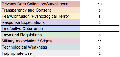
In 1985, American intelligence analyst Samuel Loring Morison was charged with espionage after leaking this satellite image of a Soviet shipyard:
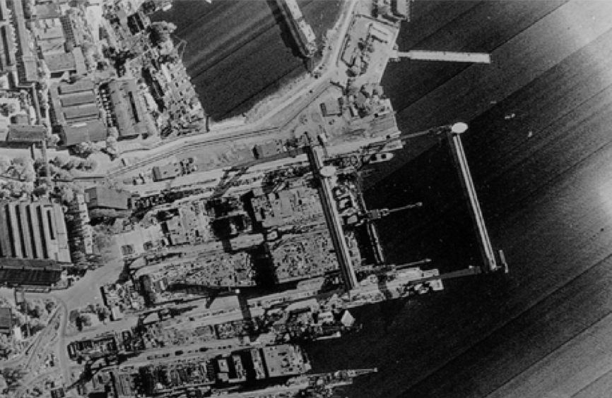
And here’s a satellite image of the same shipyard today, free & publicly available via Google Earth:

Thus begins colleague Steven Livingston’s intriguing new study entitled Remote Sensing Satellites and the Regulation of Violence in Areas of Limited Statehood. “These two images illustrate the extraordinary changes in remote sensing that have occurred since 2000, the year the first high-resolution, commercially owned and operated satellite images became available. Images that were once shrouded in state secrecy are now available to anyone possessing a computer and internet connection, sometimes even at no cost.”
Steven “considers the implications of this development for governance in areas of limited statehood.” In other words, he “explores digitally enabled collective action in areas of limited statehood” in order to answer the following question: how might remote sensing “strengthen the efforts to hold those responsible for egregious acts of violence against civil populations to greater account”?
Areas of Limited Statehood
An area of limited statehood is a “place, policy arena, or period of time when the governance capacity of the state is unrealized or faltering.” To this end, “Governance can be defined as initiatives intended to provide public goods and to create and enforce binding rules.” I find it fascinating that Steven treats “governance as an analog to collective action, a term more common to political economics.” Using the lens of limited statehood also “disentangles governance from government (or the state). This is especially important to the discussion of remote sensing satellites and their role in mitigating some of the harsher effects of limited statehood.”
In sum, “rather than a dichotomous variable, as references to failed states imply, state governance capacity is more accurately conceptualized as running along a continuum: from failed states at one end to fully consolidated states at the other.” To this end, “What might appear to be a fully consolidated state according to gross indicators might in fact be a quite limited state according to sectorial, social or even spatial grounds.” This is also true of the Global North. Take natural disasters like Hurricane Katrina, for example. Disasters can, and do, “degrade the governance capacity of a state in the affected region.”
Now, the term “limited governance” does not imply the total lack of governance. “Governance might instead come from alternative sources,” writes Steven, such as NGOs, clans and even gangs. “Most often, governance is provided by a mix of modalities […],” which is “particularly important when considering the role of technology as a sort of governance force multiplier.” Evidently, “Leveraging technology lowers the organizational burden historically associated with the provisioning of public goods. By lowering communication and collaboration costs, information and communication technology facilitates organizing without formal organizations, such as states.” To this end, “Rather than building organizations to achieve a public good, digital technologies are used to organize collective actions intended to provide a public good, even in the absence of the state. It involves a shift from a noun (organizations) to a verb (organizing).”
Remote Sensing Satellites
Some covert satellites are hard to keep out of the public eye. “The low-earth orbit and size of government satellites make them fairly easy to spot, a fact that has created a hobby: satellite tracking.” These hobbyists are able to track govern-ment satellites and to calculate their orbits; thus deducing certain features and even purpose of said satellites. What is less well known, however, are the “capabilities of the sensors or camera carried onboard.”
The three important metrics associated with remote sensing satellites are spatial resolution, spectral resolution and temporal resolution. Please see Steven’s study (pages 12-14) for a detailed description of each. “In short, ‘seeing’ involves much more data than is typically associated in popular imagination with satellite images.” Furthermore, “Spatial resolution alone may not matter as much as other technical characteristics. What is analytically possible with 30-centimeter resolution imagery may not outweigh what can be accomplished with a one-meter spatial resolution satellite with a high temporal resolution.” (Steven also provides an informative summary on the emergence of the commercial remote sensing sector including micro-satellites in pages 14-18).
The Regulation of Violence
Can non-state actors use ICTs to “alter the behavior of state actors who have or are using force […] to violate broadly recognized norms”? Clearly one element of this question relates to the possibility of verifying such abuse (although this in no way implies that state behaviors will change as a consequence). “Where the state is too weak [or unwilling] to hold its own security forces to account and to monitor, investigate, and verify the nature of their conduct, nonstate actors fill at least some of the void. Nonstate actors offer a functional equivalency to a consolidated state’s oversight functions.”

Steven highlights a number of projects that seek to use satellite imagery for the above stated purposes. These include projects by Amnesty International, Human Rights Watch, AAAS and the Harvard Humanitarian Initiative’s (HHI) Satellite Sentinel Project. These projects demonstrate that monitoring & verifying state-sanctioned violence is certainly feasible via satellite imagery. I noted as much here and here back in 2008. And I’ve had several conversations over the years with colleagues at Amnesty, AAAS and the Sentinel Project on the impact of their work on state behavior. There are reasons to be optimistic even if many (most?) of these reasons cannot be made public.
There are also reasons to be concerned as per recent conversations I’ve had with Harvard’s Sentinel Project. The latter readily admit that behavior change in no way implies that said change is a positive one, i.e., the cessation of violence. States who learn of projects that use remote sensing satellites to document the mass atrocities they are committing (or complicit in) may accelerate their slaughter and/or change strategies by taking more covert measures.
There is of course the possibility of positive behavior change; one in which “Transnational Advocacy Networks” are able to “mobilize information strategic-ally to help create new issues and categories and to persuade, pressure, and gain leverage over much more powerful organizations and governments […],” who subsequently change their behaviors to align with international norms and practices. While fraught with the conundrums of “proving” direct causality, the conversations I’ve had with some of the leading advocacy networks engaged in these networks leave me hopeful.
In conclusion
Satellite imagery—once the sole purview of intelligence agencies—is increasingly accessible to these advocacy networks who can use said imagery to map unregulated state violence. To this end, “States no longer enjoy a mono-poly on the synoptic view of earth from space. […] Nonstate actors, from corporations to nongovernmental organizations and community groups now have access to the means of ordering a disorderly world on their own terms.”
The extent to which this loss of monopoly is positively affecting state behavior is unclear (or not fully public). Either way, and while obvious, transparency in no way implies accountability. Documenting state atrocities does not automatically end or prevent them—a point clearly lost on a number of conflict early warning “experts” who overlooked this issue in the 1990s and 2000s. Prevention is political; and political will is not an icon on the computer screen that one can turn on with a double-click of the mouse.
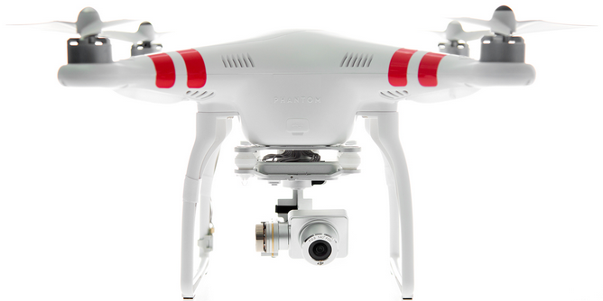
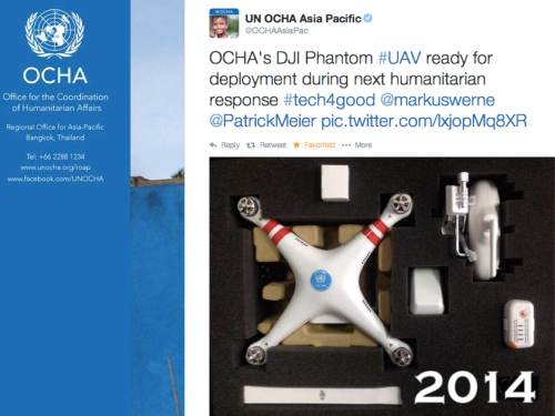
In addition to the above, Steven and I have also been exploring the question of UAVs within the context of limited statehood and the regulation of violence for a future book we’re hoping to co-author. While NGOs and community groups are in no position to operate or own a satellite (typical price tag is $300 million), they can absolutely own and operate a $500 UAV. Just in the past few months, I’ve had 3 major human rights organization contact me for guidance on the use of UAVs for human rights monitoring. How all this eventually plays out will hopefully feature in our future book.