
Thank you, Digital Jedis!
Every Click you made on MicroMappers was a gift. Typhoon Ruby (Hagupit) disrupted the lives of many and caused damage in regions already affected by previous disasters. As MicroMappers, you gave your time, clicks and skills to make a difference. Catherine, the Head of the UN’s Information Management Unit in the Philippines had this to say: “I would like to thank all the volunteers […] for their invaluable contribution over the past few days. We are lucky that Hagupit [Ruby] made less damages than expected and that the emergency quickly scaled down.”
MicroMappers and our partners at the Standby Task Force (SBTF) were activated by the United Nations Office for the Coordination of Humanitarian Affairs (OCHA). The Mission?
To augment the situational awareness of humanitarian actors on the ground by making sense of social media generated following the Typhoon.
Over the course of 72 hours, these Digital Jedis united to MicroMap one Click at a time. By reviewing tweets and image, each MicroMapper built collective intelligence and insights that were used to build a comprehensive situational awareness reports and maps for the UN. Many hands, and in this case, Clicks, make light work.
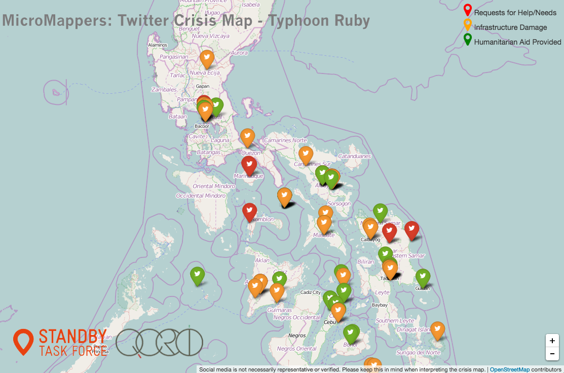
As Catherine rightly notes, there was thankfully less damage than many feared. This explains why our MicroMaps (above and below) are thankfully not riddled with hundreds of markers. In addition, we prioritize quality over quantity at MicroMappers. Our UN partners had specifically asked for tweets related to:
(1) Requests for Help / Needs
(2) Infrastructure Damage
(3) Humanitarian Aid Provided
Together, these tweets—which are mapped above—represented less than 5% of the Ruby-related tweets that were collected during the first 72 hours of the Typhoon making landfall. This doesn’t mean that only 5% of the information on Twitter was relevant for emergency response, however. Indeed, we also tagged tweets that were not related to the above 3 categories but that were still informative. These constituted more than 20% of all tweets collected (which are not included in the map above). In the analysis provided to UN partners, we did include a review of those other relevant tweets.

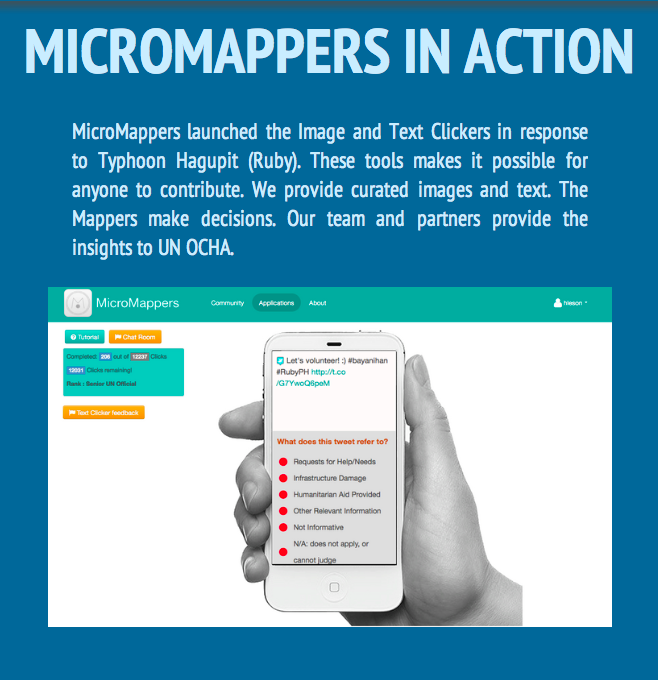
Some 700 Digital Jedis joined the response online, a new record for MicroMappers! An astounding 50,394 Clicks were made using the Text Clicker pictured above (each tweet was reviewed by at least 3 digital volunteers for quality assurance purposes). And a further 3,555 Clicks were carefully made by the SBTF to geo-locate (map) relevant tweets. In other words, close to 55,000 Clicks went into making the high quality map displayed above! That’s over 12 Clicks per minute non-stop for more than 4,300 consecutive minutes!

The United Nations also asked Digital Jedis to identify pictures posted on Twitter that showed disaster damage. Over 30,000 Clicks went into this operation with a further 7,413 Clicks made by the SBTF to map images that showed severe and mild damage. In sum, over 40,000 Clicks went into the MicroMap above. Overall, the entire MicroMappers response was powered by close to 100,000 Clicks!


Digital Jedis have yet again shown that together, we can help people get positively involved in their world, even when half-a-globe and many timezones away. Yes, we can and should donate $$ to support relief efforts and good causes around the world but we can also get directly involved by donating our time, or what we call M&M’s, Minutes and Mouse clicks. This year MicroMappers have mobilized to support wildlife protection in Namibia, food security efforts in the Philippines and of course this most recent response to Typhoon Ruby. On that note, thanks again to all volunteers who supported the MicroMappers response to the Typhoon in partnership with the United Nations. You truly are Digital Jedis! And the UK Guardian certainly agrees, check out their article on our digital response.
So what’s next? We will continue to solicit your feedback on how to improve the Clickers and will get started right away. (Add your MicroMappers feedback here). In the meantime, we will leave the Clickers online for newcomers who wish to practice. We are also in touch with the UN and UAV partners in the Philippines as they may soon fly their small, remote-control planes to take aerial photographs over disaster affected areas. If they do, they will send us the photographs for analysis via MicroMappers, so stay tuned.
In closing, MicroMappers was developed by QCRI in partnership SBTF/OCHA. So a million thanks to the QCRI team and SBTF for deploying MicroMappers in support of these digital humanitarian efforts. Special thanks go to Ji Lucas, Jus Mackinnon, ChaTo Castillo, Muhammad Imran, Heather Leson, Sarah Vieweg and last but certainly not least Peter Mosur.
(Ed. note: Blog post was cross-posted from MicroMappers.org. Infrographic uses Infogr.am software)
