Tag Archives: Software

New: List of Software for UAVs and Aerial Imagery

My research team and I at the Humanitarian UAV Network (UAViators) have compiled a list of more than 30 common software platforms used to operate UAVs and analyze resulting aerial imagery. We carried out this research to provide humanitarian organizations with a single repository where they can review existing software platforms (including free & open source solutions) for their humanitarian UAV missions. The results, available here, provide a brief description of each software platform along with corresponding links for additional information and download. We do realize that this list is not (yet) comprehensive, so we hope you’ll help us fill remaining gaps. This explains why we’ve made our research available as an open, editable Google Doc.

UAV software

Many thanks to my research assistant Peter Mosur for taking the lead on this. We have additional research documents available here on the UAViators website.

bio

See also:

  • Humanitarian UAV Network: Strategy for 2014-2015 [link]
  • Humanitarians in the Sky: Using UAVs for Disaster Response [link]
  • Low-Cost UAV Applications for Post-Disaster Damage Assessments: A Streamlined Workflow [Link]

How to Program UAV Flights for Humanitarian Missions

UAVs are increasingly being flown autonomously rather than manually. But how does this actually work? In this blog post, I seek to “demystify” the process of programming UAV flights. While a number of platforms exist to program UAVs, they largely resemble each other. So I used the eMotion software that comes with senseFly’s eBee UAV to provide the demo below, which is actually based on a real humanitarian mission in the Philippines after Typhoon Haiyan. Please be sure to read the Humanitarian UAV Network’s Code of Conduct and Operational Check List before programming any UAV flights for humanitarian missions.

This demo is for simple flights only. If you’re flying near hills or mountains, for example, you’ll need to upload elevation data. I’ll provide a demo on how to program more complicated flights in the future. Of course, humanitarian UAV missions don’t end with the landing. The imagery needs to be analyzed and translated into information products to support decision-making. This requires using image processing platforms like Pix4D and PhotoScan. I’ll provide a demo on this in the future. In the meantime, if you’ve captured aerial videos or pictures of disaster areas, the easiest way to share them with humanitarian organizations and others is by posting them on the Humanitarian UAV Network’s Crisis Map. You can also partner with Humanitarian OpenStreetMap and MicroMappers to crowdsource the analysis of aerial imagery. These groups can be contacted via the Digital Humanitarian Network.

Bio

Acknowledgements:

See Also:

  • Official UN Policy Brief on Humanitarian UAVs [link]
  • Humanitarian UAV Network: Strategy for 2014-2015 [link]
  • Common Misconceptions About Humanitarian UAVs [link]
  • Reflections on the Use of UAVs in Humanitarian Interventions [link]
  • Humanitarians in the Sky: Using UAVs for Disaster Response [link]
  • Google Already Developing UAV’s for Disaster Response [link]
  • WHO Using UAVs to Transport Medical Supplies [link]

Comprehensive List of UAVs for Humanitarian Response

The Humanitarian UAV Network (UAViators) is carrying out a comprehensive evaluation of UAVs and related technologies for use in humanitarian settings. We’ve developed an evaluation framework for this assessment and have now drafted this list of UAV models to determine which are worth evaluating. As you’ll note, the link also points to three other related lists: cameras, sensors and software for image processing and analysis. We’ll be evaluating these as well to identify which are the best fit for use by humanitarians in the field.

xUAV3

We are actively seeking feedback on these preliminary lists in order to identify which items we should prioritize for evaluation. The lists are available in this open and editable Google Spreadsheet. Each list include a column for you to add any comments you might have about any entries. We’re particularly interested in getting feedback on which items are not worth evaluating and which should be added at to the list. Thank you!

Bio

See Also:

  • Crisis Map of UAV/Aerial Videos for Disaster Response [link]
  • How UAVs are Making a Difference in Disaster Response [link]
  • Humanitarians Using UAVs for Post Disaster Recovery [link]
  • Grassroots UAVs for Disaster Response [link]
  • Using UAVs for Search & Rescue [link]
  • Debrief: UAV/Drone Search & Rescue Challenge [link]
  • Crowdsourcing Analysis of UAV Imagery for Search/Rescue [link]
  • Check-List for Flying UAVs in Humanitarian Settings [link]

Evaluating UAVs for Humanitarian Response

The Humanitarian UAV Network is carrying out an evaluation of UAVs and related technologies for use in humanitarian settings. The related technologies being evaluated include cameras, payload units, image processing & analysis software. As a first step, we have created an evaluation framework based on parameters relevant for field-based deployments of UAVs by humanitarian organizations. Before moving to the next step in the evaluation—identifying which UAVs and related technologies to evaluate—we want to make sure that we’re on the right track as far as our evaluation framework goes. So the purpose of this blog post is to seek feedback on said framework.

UAViators Logo

To recap, we are evaluating four distinct technologies: 1) UAVs; 2) Cameras; 3) Payload units; and 4) Image Processing & Analysis Software specifically for humanitarian use. So below are the evaluation criteria we have identified for each technology.

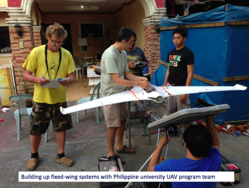
UAVs: Type, Cost, Size, Weight, Appearance, Noise Factor, Durability, Ease of Use, Ease of Repair, Payload Capacity, Flight Time, Transmitter Range,  Autonomy, Camera/Gimbal Compatibility and Legality/Customs.

Most of the parameters are self-explanatory but a few require some elaboration. Type refers to whether the UAV is a fixed-wing, rotary-wing or a hybrid. Appearance seeks to evaluate whether the UAV airframe looks threatening or more like a toy, for example. Autonomy refers to whether the UAV can be flown autonomously. Legality/Customs seeks to assess whether the transportation of the UAV across borders is likely to be easy or challenging.

Cameras: Cost, Size, Weight, Megapixels, Memory, Control, Durability, Easy of Use, Ease of Repair, Lens Type and Gimbal Compatibility.

Payload Units: Cost, Size, Weight, Type of Release Mechanism, Release Mechanism, Ease of Use and Ease of Repair.

Image Software: Cost, Image Processing, Image Analysis, Ease of Use, System Requirements, Compatibility and Type of License.

We need to make sure that we fill any gaps in our evaluation criteria before proceeding with the assessment. So what parameters are we missing?

bio

See Also:

  • Welcome to the Humanitarian UAV Network [link]
  • How UAVs are Making a Difference in Disaster Response [link]
  • Humanitarians Using UAVs for Post Disaster Recovery [link]
  • Grassroots UAVs for Disaster Response [link]
  • Using UAVs for Search & Rescue [link]
  • Debrief: UAV/Drone Search & Rescue Challenge [link]
  • Crowdsourcing Analysis of UAV Imagery for Search/Rescue [link]
  • Check-List for Flying UAVs in Humanitarian Settings [link]


Mobile Spying Software Sophistication

Computerworld New Zealand reports that spying programs for mobile phones are likely to grow in sophistication and stealth as the business around selling the tools grows.

There is increasing evidence that money from selling the tools will create a stronger incentive for more accomplished programmers to get into the game, which could make the programs harder to detect. The prediction follows what has happened with the malware writers in the PC market. Many hackers are now in the business of selling easy-to-use tools to less technical hackers rather than hacking into PCs themselves.

One of the latest tools on the market is Mobile SpySuite, which some believe is the first spy tool generator for mobiles. It sells for US$12,500. The number of mobile spyware programs pales in comparison to the number of such programs available for PCs. However, mobile spying programs are harder to track, since security companies don’t see as many samples circulating on the internet as they do of malicious software for PCs.

Some of the more well-known spy programs are Neo-call and FlexiSpy. Neo-call is capable of secretly forwarding SMS (Short Message Service) text messages to another phone, transmitting a list of phone numbers called, and logging keystrokes. FlexiSpy has a neat, web-based interface that shows details of call times, numbers and SMSes, and it can even use a phone’s GPS (Global Positioning System) receiver to pinpoint the victim’s location.

I’m not too worried though, SecureSMS would have those forwarded SMS texts encrypted. And besides, as SpySuite increases it’s market share, this will increase customer demand for tighter data security. Companies like CellTrust will move in and offer anti-spying tools. And so on, and so on. In other words, we’re likely to see the dynamic observed vis-a-vis PCs, i.e., the basic dynamic of evolutionary biology: adaptation.

Patrick Philippe Meier