Tag Archives: Grassroots

Grassroots UAVs for Disaster Response

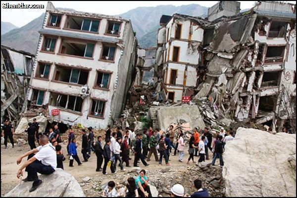
I was recently introduced to a new initiative that seeks to empower grassroots communities to deploy their own low-cost xUAVs. The purpose of this initiative? To support locally-led disaster response efforts and in so doing transfer math, science and engineering skills to local communities. The “x” in xUAV refers to expendable. The initiative is a partnership between California State University (Long Beach), University of Hawaii, Embry Riddle, The Philippine Council for Industry, Energy & Emerging Technology Research & Development, Skyeye, Aklan State University and Ateneo de Manila University in the Philippines. The team is heading back to the Philippines next week for their second field mission. This blog post provides a short overview of the project’s approach and the results from their first mission, which took place during December 2013-February 2014.

xUAV1

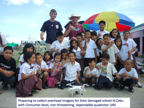
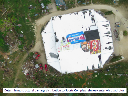
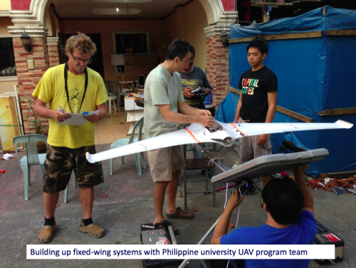
The xUAV team is specifically interested in a new category of UAVs, those that are locally available, locally deployable, low-cost, expendable and extremely easy to use. Their first field mission to the Philippines focused on exploring the possibilities. The pictures above/below (click to enlarge) were kindly shared by the Filipinos engaged in the project—I am very grateful to them for allowing me to share these publicly. Please do not reproduce these pictures without their written permission, thank you.

xUAV2

I spoke at length with one of the xUAV team leads, Ted Ralston, who is heading back to the Philippines the second field mission. The purpose of this follow up visit is to shift the xUAV concept from experimental to deployable. One area that his students will be focusing on with the University of Manila is the development of a very user-friendly interface (using a low-cost tablet) to pilot the xUAVs so that local communities can simply tag way-points on a map that the xUAV will then automatically fly to. Indeed, this is where civilian UAVs are headed, full automation. A good example of this trend towards full automation is the new DroidPlanner 2.0 App just released by 3DRobotics. This free app provides powerful features to very easily plan autonomous flights. You can even create new flight plans on the fly and edit them onsite.

DroidPlanner.png

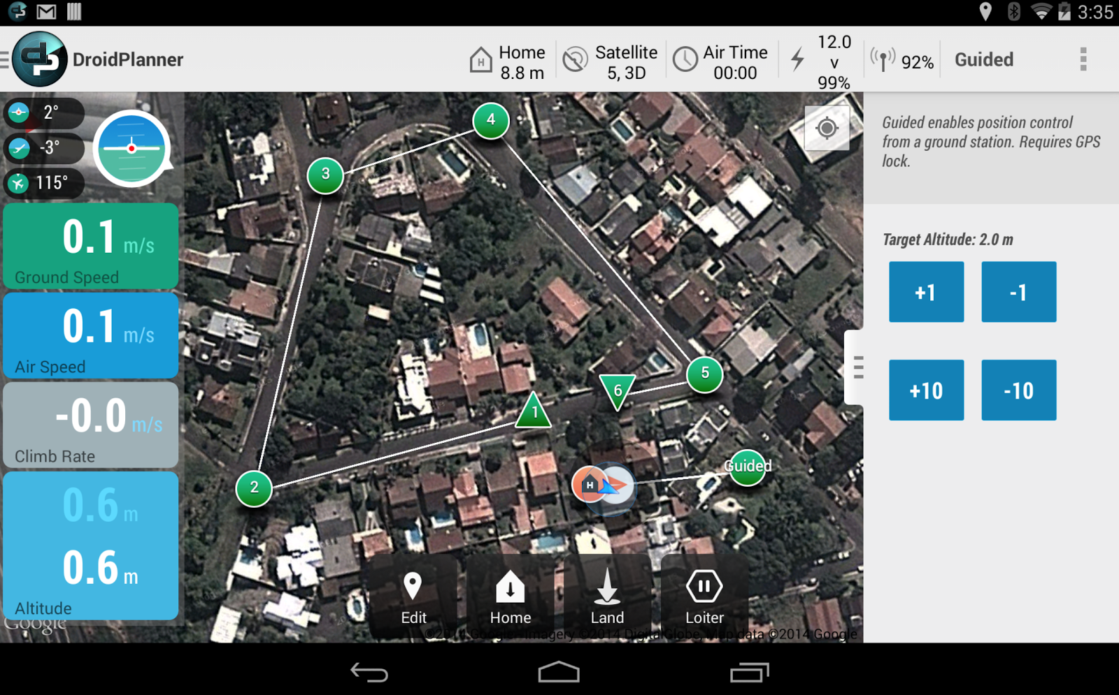
So the xUAV team will focus on developing software for automated take-off and landing as well as automated adjustments for wind conditions when the xUAV is airborne, etc. The software will also automatically adjust the xUAV’s flight parameters for any added payloads. Any captured imagery would then be made easily viewable via touch-screen directly from the low-cost tablet.

xUAV3

One of the team’s top priorities throughout this project is to transfer their skills to young Filipinos, given them hands on training in science, math and engineering. An equally important, related priority, is their focus on developing local partnerships with multiple partners. We’re familiar with ideas behind Public Participatory GIS (PPGIS) vis-a-vis the participatory use of geospatial information systems and technologies. The xUAV team seeks to extend this grassroots approach to Public Participatory UAVs.

xUAV4

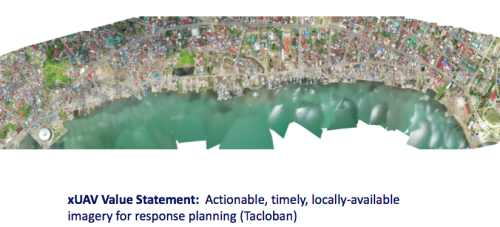
I’m supporting this xUAV initiative in a number of ways and will be uploading the team’s UAV imagery (videos & still photos) from their upcoming field mission to MicroMappers for some internal testing. I’m particularly interested in user-generated (aerial) content that is raw and not pre-processed or stitched together, however. Why? Because I expect this type of imagery to grow in volume given the very rapid growth of the personal micro-UAV market. For more professionally produced and stitched-together aerial content, an ideal platform is Humanitarian OpenStreetMap’s Tasking Server, which is tried and tested for satellite imagery and which was recently used to trace processed UAV imagery of Tacloban.

Screen Shot 2014-03-12 at 1.03.20 PM

I look forward to following the xUAV team’s efforts and hope to report on the outcome of their second field mission. The xUAV initiative fits very nicely with the goals of the Humanitarian UAV Network (UAViators). We’ll be learning a lot in the coming weeks and months from our colleagues in the Philippines.

bio

How Crowdsourced Disaster Response in China Threatens the Government

In 2010, Russian volunteers used social media and a live crisis map to crowdsource their own disaster relief efforts as massive forest fires ravaged the country. These efforts were seen by many as both more effective and visible than the government’s response. In 2011, Egyptian volunteers used social media to crowdsource their own humanitarian convoy to provide relief to Libyans affected by the fighting. In 2012, Iranians used social media to crowdsource and coordinate grassroots disaster relief operations following a series of earthquakes in the north of the country. Just weeks earlier, volunteers in Beijing crowd-sourced a crisis map of the massive flooding in the city. That map was immediately available and far more useful than the government’s crisis map. In early 2013, a magnitude 7  earthquake struck Southwest China, killing close to 200 and injuring more than 13,000. The response, which was also crowdsourced by volunteers using social media and mobile phones, actually posed a threat to the Chinese Government.

chinaquake

“Wang Xiaochang sprang into action minutes after a deadly earthquake jolted this lush region of Sichuan Province […]. Logging on to China’s most popular social media sites, he posted requests for people to join him in aiding the survivors. By that evening, he had fielded 480 calls” (1). While the government had declared the narrow mountain roads to the disaster-affected area blocked to unauthorized rescue vehicles, Wang and hitchhiked his way through with more than a dozen other volunteers. “Their ability to coordinate — and, in some instances, outsmart a government intent on keeping them away — were enhanced by Sina Weibo, the Twitter-like microblog that did not exist in 2008 but now has more than 500 million users” (2). And so, “While the military cleared roads and repaired electrical lines, the volunteers carried food, water and tents to ruined villages and comforted survivors of the temblor […]” (3). Said Wang: “The government is in charge of the big picture stuff, but we’re doing the work they can’t do” (4).

In response to this same earthquake, another volunteer, Li Chengpeng, “turned to his seven million Weibo followers and quickly organized a team of volunteers. They traveled to the disaster zone on motorcycles, by pedicab and on foot so as not to clog roads, soliciting donations via microblog along the way. What he found was a government-directed relief effort sometimes hampered by bureaucracy and geographic isolation. Two days after the quake, Mr. Li’s team delivered 498 tents, 1,250 blankets and 100 tarps — all donated — to Wuxing, where government supplies had yet to arrive. The next day, they hiked to four other villages, handing out water, cooking oil and tents. Although he acknowledges the government’s importance during such disasters, Mr. Li contends that grass-roots activism is just as vital. ‘You can’t ask an NGO to blow up half a mountain to clear roads and you can’t ask an army platoon to ask a middle-aged woman whether she needs sanitary napkins, he wrote in a recent post” (5).

chinaquake2

As I’ve blogged in the past (here and here, for example), using social media to crowdsourced grassroots disaster response efforts serves to create social capital and strengthen collective action. This explains why the Chinese government (and others) faced a “groundswell of social activism” that it feared could “turn into government opposition” following the earthquake (6). So the Communist Party tried to turn the disaster into a “rallying cry for political solidarity. ‘The more difficult the circumstance, the more we should unite under the banner of the party,’ the state-run newspaper People’s Daily declared […], praising the leadership’s response to the earthquake” (7).

This did not quell the rise in online activism, however, which has “forced the government to adapt. Recently, People’s Daily announced that three volunteers had been picked to supervise the Red Cross spending in the earthquake zone and to publish their findings on Weibo. Yet on the ground, the government is hewing to the old playbook. According to local residents, red propaganda banners began appearing on highway overpasses and on town fences even before water and food arrived. ‘Disasters have no heart, but people do,’ some read. Others proclaimed: ‘Learn from the heroes who came here to help the ones struck by disaster’ (8). Meanwhile, the Central Propaganda Department issued a directive to Chinese newspapers and websites “forbidding them to carry negative news, analysis or commentary about the earthquake” (9). Nevertheless, “Analysts say the legions of volunteers and aid workers that descended on Sichuan threatened the government’s carefully constructed narrative about the earthquake. Indeed, some Chinese suspect such fears were at least partly behind official efforts to discourage altruistic citizens from coming to the region” (10).

Aided by social media and mobile phones, grassroots disaster response efforts present a new and more poignant “Dictator’s Dilemma” for repressive regimes. The original Dictator’s Dilemma refers to an authoritarian government’s competing interest in using information communication technology by expanding access to said technology while seeking to control the democratizing influences of this technology. In contrast, the “Dictator’s Disaster Lemma” refers to a repressive regime confronted with effectively networked humanitarian response at the grassroots level, which improves collective action and activism in political contexts as well. But said regime cannot prevent people from helping each other during natural disasters as this could backfire against the regime.

bio

See also:

 •  How Civil Disobedience Improves Crowdsourced Disaster Response [Link]

From Grassroots Mapping to One Satellite Per Child

There were some amazing presentations at Where 2.0, but for me personally, Jeffrey Warren’s talk on Community-based Grassroots Mapping with Balloons and Kites in Lima was the most exciting. Jeffrey and his colleagues were inspired by two MIT undergraduate students who “launched a digital camera into near-space to take photographs of the earth from high up above.”

Jeff and colleague traveled to Lima in January 2010 to work with children and adults from several communities to bring a truly participatory (and fun!) approach to mapping.

Seeking to invert the traditional power structure of cartography, the grassroots mappers used helium balloons and kites to loft their own “community satellites” made with inexpensive digital cameras. The resulting images, which are owned by the residents, are georeferenced and stitched into maps which are 100x higher resolution that those offered by Google, at extremely low cost.

In some cases these maps may be used to support residents’ claims to land title. By creating open-source tools to include everyday people in exploring and defining their own geography, we hopes to enable a diverse set of alternative agendas and practices, and to emphasize the fundamentally narrative and subjective aspects of mapping over its use as a medium of control.

Once several pictures have been taken, they can be “stitched together” to form a map like the one below. The stitching can be done by hand or using this neat tool.

All it takes is $100 for the equipment below. In fact, you could even use $1.30 trash bags instead to reduce the cost. I highly recommend looking through this fun illustrated guide.

I also like how the communities used tracing paper to annotate the maps they produced from the balloons. This is something I had wanted to do for this community mapping project in the Sudan.

I absolutely love this project. It’s easy, cheap, participatory, empowering and fun. Jeff and company are democratizing aerial mapping. I’d love to see this approach take off all over the world and would like to find some use cases in the humanitarian context, e.g., in post-disaster reconstruction and development. Imagine if local communities in Haiti could use balloon mapping to hold the development community accountable for the way their own country is being rebuilt. This approach can democratize urban planning in post-disaster environments.

Do check out the Grassroots Mapping website. You can also sign up for the group’s mailing list. If you’re in the Boston area, you may want to join Jeffrey and friends for some balloon mapping excercises. I definitely will! In the meantime, check out Jeff’s Ignite Talk from the 2009 CrisisMappers Conference.

Patrick Philippe Meier