Tag Archives: WorldBank

World Bank Using UAVs for Disaster Risk Reduction in Tanzania

An innovative World Bank team in Tanzania is exploring the use of UAVs for disaster risk reduction efforts. Spearheaded by colleague Edward Anderson, the team recently partnered with friends at Drone Adventures to capture very high-resolution images of flood-prone areas in the country’s capital. This imagery is now being used to generate Digital Terrain Models to develop more reliable flood-inundation models at an unparalleled level of resolution. This project is a joint effort with the Commission for Science and Technology (COSTECH) and kindly supported by the Swedish International Development Agency and the Global Facility for Disaster Risk Reduction (GFDRR), working in partnership with the Tanzania Red Cross.

Drone Adventures flew dozens of flights over the course of 10 days, covering close to 90km² at a resolution of 4cm-8cm. They used eBees, which weigh about 700 grams and are 95% foam-based with a small properly facing the back, which makes the UAV extra safe. Here are some pictures (click to enlarge) from the recent mission in Dar es Salam, courtesy of Mark Iliffe from the Bank.

16544751406_dd5feb3ae3_z

15948142154_81b0b854bf_z

Screen Shot 2015-08-14 at 1.17.32 PM

Screen Shot 2015-08-14 at 1.28.41 PM

16569015351_b1d0907f7f_z

Screen Shot 2015-08-16 at 4.18.40 PM

The World Bank Team also used a DJI Phantom 2 UAV pictured below. Like Drone Adventures, they also took the time to engage local communities. This approach to community engagement in UAV projects is an important component of the UAViators Code of Conduct and Guidelines. The team is using the DJI Phantom to inform urban planning and transportation conversations, and to quickly assess flood impact, as this video explains.

16569539912_0c7a5ca5b2_z

16384737537_773757f8fc_z

16384734007_e1b739b1f0_z
16570687475_0846dcaf87_z
Screen Shot 2015-08-16 at 4.18.16 PM

Screen Shot 2015-08-16 at 4.17.53 PM

Most of the resulting imagery has already been added to OpenAerialMap here. The imagery is also being used here as part of the Missing Maps project. This has already improved the level of detail of Dar es Salam maps. For example, compare the level of detail in this map before the aerial imagery was made available:

Screen Shot 2015-08-14 at 1.55.26 PM

With these more detailed maps enabled by the availability of aerial imagery:

Screen Shot 2015-08-14 at 1.57.22 PM

Screen Shot 2015-08-14 at 2.01.40 PM

Screen Shot 2015-08-14 at 2.02.12 PM

And here’s a comparison of a satellite image (taken from Google Earth) of a neighborhood in Dar es Salam with an areal image (from an eBee) at around the same spatial resolution.

Screen Shot 2015-08-16 at 5.34.08 PM

thumb_Screen Shot 2015-08-16 at 5.37.02 PM_1024

As Mark from the World Bank noted during a recent conversation, making this aerial imagery open and making the data derived from this imagery open “gives agencies and municipalities data that they’ve not had access to previously. But there are still outstanding questions such as authoritativeness that need to be resolved. There is a lot of institutional work with statistics and mapping agencies that is ongoing to validate the data and ensure they’re happy with it, prior to it augmenting traditional mapping practices. That’s where we’re at currently.”

Acknowledgements: Many thanks to Edward & Mark for sharing their efforts.

Could Lonely Planet Render World Bank Projects More Transparent?

That was the unexpected question that my World Bank colleague Johannes Kiess asked me the other day. I was immediately intrigued. So I did some preliminary research and offered to write up a blog post on the idea to solicit some early feedback. According to recent statistics, international tourist arrivals numbered over 1 billion in 2012 alone. Of this population, the demographic that Johannes is interested in comprises those intrepid and socially-conscious backpackers who travel beyond the capitals of developing countries. Perhaps the time is ripe for a new form of tourism: Tourism for Social Good.

tourism_socialmedia

There may be a real opportunity to engage a large crowd because travelers—and in particular the backpacker type—are smartphone savvy, have time on their hands, want to do something meaningful, are eager to get off the beaten track and explore new spaces where others do not typically trek. Johannes believes this approach could be used to map critical social infrastructure and/or to monitor development projects. Consider a simple smartphone app, perhaps integrated with existing travel guide apps or Tripadvisor. The app would ask travelers to record the quality of the roads they take (with the GPS of their smartphone) and provide feedback on the condition, e.g.,  bumpy, even, etc., every 50 miles or so.

They could be asked to find the nearest hospital and take a geotagged picture—a scavenger hunt for development (as Johannes calls it); Geocaching for Good? Note that governments often do not know exactly where schools, hospitals and roads are located. The app could automatically alert travelers of a nearby development project or road financed by the World Bank or other international donor. Travelers could be prompted to take (automatically geo-tagged) pictures that would then be forwarded to development organizations for subsequent visual analysis (which could easily be carried out using microtasking). Perhaps a very simple, 30-second, multiple-choice survey could even be presented to travelers who pass by certain donor-funded development projects. For quality control purposes, these pictures and surveys could easily be triangulated. Simple gamification features could also be added to the app; travelers could gain points for social good tourism—collect 100 points and get your next Lonely Planet guide for free? Perhaps if you’re the first person to record a road within the app, then it could be named after you (of course with a notation of the official name). Even Photosynth could be used to create panoramas of visual evidence.

The obvious advantage of using travelers against the now en vogue stakeholder monitoring approach is that they said bagpackers are already traveling there anyway and have their phones on them to begin with. Plus, they’d be independent third parties and would not need to be trained. This obviously doesn’t mean that the stakeholder approach is not useful. The travelers strategy would simply be complementary. Furthermore, this tourism strategy comes with several key challenges, such as the safety of backpackers who choose to take on this task, for example. But appropriate legal disclaimers could be put in place, so this challenge seems surmountable. In any event, Johannes, together with his colleagues at the World Bank (and I), hope to explore this idea of Tourism for Social Good further in the coming months.

In the meantime, we would be very grateful for feedback. What might we be overlooking? Would you use such an app if it were available? Where can we find reliable statistics on top backpacker destinations and flows?

Bio

See also: 

  • What United Airlines can Teach the World Bank about Mobile Accountability [Link]

Zooniverse: The Answer to Big (Crisis) Data?

Both humanitarian and development organizations are completely unprepared to deal with the rise of “Big Crisis Data” & “Big Development Data.” But many still hope that Big Data is but an illusion. Not so, as I’ve already blogged here, here and here. This explains why I’m on a quest to tame the Big Data Beast. Enter Zooniverse. I’ve been a huge fan of Zooniverse for as long as I can remember, and certainly long before I first mentioned them in this post from two years ago. Zooniverse is a citizen science platform that evolved from GalaxyZoo in 2007. Today, Zooniverse “hosts more than a dozen projects which allow volunteers to participate in scientific research” (1). So, why do I have a major “techie crush” on Zooniverse?

Oh let me count the ways. Zooniverse interfaces are absolutely gorgeous, making them a real pleasure to spend time with; they really understand user-centered design and motivations. The fact that Zooniverse is conversent in multiple disciplines is incredibly attractive. Indeed, the platform has been used to produce rich scientific data across multiple fields such as astronomy, ecology and climate science. Furthermore, this citizen science beauty has a user-base of some 800,000 registered volunteers—with an average of 500 to 1,000 new volunteers joining every day! To place this into context, the Standby Volunteer Task Force (SBTF), a digital humanitarian group has about 1,000 volunteers in total. The open source Zooniverse platform also scales like there’s no tomorrow, enabling hundreds of thousands to participate on a single deployment at any given time. In short, the software supporting these pioneering citizen science projects is well tested and rapidly customizable.

At the heart of the Zooniverse magic is microtasking. If you’re new to microtasking, which I often refer to as “smart crowdsourcing,” this blog post provides a quick introduction. In brief, Microtasking takes a large task and breaks it down into smaller microtasks. Say you were a major (like really major) astro-nomy buff and wanted to tag a million galaxies based on whether they are spiral or elliptical galaxies. The good news? The kind folks at the Sloan Digital Sky Survey have already sent you a hard disk packed full of telescope images. The not-so-good news? A quick back-of-the-envelope calculation reveals it would take 3-5 years, working 24 hours/day and 7 days/week to tag a million galaxies. Ugh!

Screen Shot 2013-03-25 at 4.11.14 PM

But you’re a smart cookie and decide to give this microtasking thing a go. So you upload the pictures to a microtasking website. You then get on Facebook, Twitter, etc., and invite (nay beg) your friends (and as many strangers as you can find on the suddenly-deserted digital streets), to help you tag a million galaxies. Naturally, you provide your friends, and the surprisingly large number good digital Samaritans who’ve just show up, with a quick 2-minute video intro on what spiral and elliptical galaxies look like. You explain that each participant will be asked to tag one galaxy image at a time by simply by clicking the “Spiral” or “Elliptical” button as needed. Inevitably, someone raises their hands to ask the obvious: “Why?! Why in the world would anyone want to tag a zillion galaxies?!”

Well, only cause analyzing the resulting data could yield significant insights that may force a major rethink of cosmology and our place in the Universe. “Good enough for us,” they say. You breathe a sigh of relief and see them off, cruising towards deep space to bolding go where no one has gone before. But before you know it, they’re back on planet Earth. To your utter astonishment, you learn that they’re done with all the tagging! So you run over and check the data to see if they’re pulling your leg; but no, not only are 1 million galaxies tagged, but the tags are highly accurate as well. If you liked this little story, you’ll be glad to know that it happened in real life. GalaxyZoo, as the project was called, was the flash of brilliance that ultimately launched the entire Zooniverse series.

Screen Shot 2013-03-25 at 3.23.53 PM

No, the second Zooniverse project was not an attempt to pull an Oceans 11 in Las Vegas. One of the most attractive features of many microtasking platforms such as Zooniverse is quality control. Think of slot machines. The only way to win big is by having three matching figures such as the three yellow bells in the picture above (righthand side). Hit the jackpot and the coins will flow. Get two out three matching figures (lefthand side), and some slot machines may toss you a few coins for your efforts. Microtasking uses the same approach. Only if three participants tag the same picture of a galaxy as being a spiral galaxy does that data point count. (Of course, you could decide to change the requirement from 3 volunteers to 5 or even 20 volunteers). This important feature allows micro-tasking initiatives to ensure a high standard of data quality, which may explain why many Zooniverse projects have resulted in major scientific break-throughs over the years.

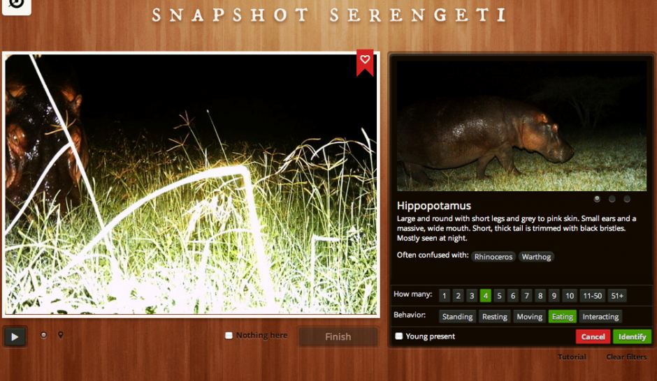
The Zooniverse team is currently running 15 projects, with several more in the works. One of the most recent Zooniverse deployments, Planet Four, received some 15,000 visitors within the first 60 seconds of being announced on BBC TV. Guess how many weeks it took for volunteers to tag over 2,000,0000 satellite images of Mars? A total of 0.286 weeks, i.e., forty-eight hours! Since then, close to 70,000 volunteers have tagged and traced well over 6 million Martian “dunes.” For their Andromeda Project, digital volunteers classified over 7,500 star clusters per hour, even though there was no media or press announce-ment—just one newsletter sent to volunteers. Zooniverse de-ployments also involve tagging earth-based pictures (in contrast to telescope imagery). Take this Serengeti Snapshot deployment, which invited volunteers to classify animals using photographs taken by 225 motion-sensor cameras in Tanzania’s Serengeti National Park. Volunteers swarmed this project to the point that there are no longer any pictures left to tag! So Zooniverse is eagerly waiting for new images to be taken in Serengeti and sent over.

Screen Shot 2013-03-23 at 7.49.56 PM

One of my favorite Zooniverse features is Talk, an online discussion tool used for all projects to provide a real-time interface for volunteers and coordinators, which also facilitates the rapid discovery of important features. This also allows for socializing, which I’ve found to be particularly important with digital humanitarian deployments (such as these). One other major advantage of citizen science platforms like Zooniverse is that they are very easy to use and therefore do not require extensive prior-training (think slot machines). Plus, participants get to learn about new fields of science in the process. So all in all, Zooniverse makes for a great date, which is why I recently reached out to the team behind this citizen science wizardry. Would they be interested in going out (on a limb) to explore some humanitarian (and development) use cases? “Why yes!” they said.

Microtasking platforms have already been used in disaster response, such as MapMill during Hurricane SandyTomnod during the Somali Crisis and CrowdCrafting during Typhoon Pablo. So teaming up with Zooniverse makes a whole lot of sense. Their microtasking software is the most scalable one I’ve come across yet, it is open source and their 800,000 volunteer user-base is simply unparalleled. If Zooniverse volunteers can classify 2 million satellite images of Mars in 48 hours, then surely they can do the same for satellite images of disaster-affected areas on Earth. Volunteers responding to Sandy created some 80,000 assessments of infrastructure damage during the first 48 hours alone. It would have taken Zooniverse just over an hour. Of course, the fact that the hurricane affected New York City and the East Coast meant that many US-based volunteers rallied to the cause, which may explain why it only took 20 minutes to tag the first batch of 400 pictures. What if the hurricane had hit a Caribbean instead? Would the surge of volunteers may have been as high? Might Zooniverse’s 800,000+ standby volunteers also be an asset in this respect?

Screen Shot 2013-03-23 at 7.42.22 PM

Clearly, there is huge potential here, and not only vis-a-vis humanitarian use-cases but development one as well. This is precisely why I’ve already organized and coordinated a number of calls with Zooniverse and various humanitarian and development organizations. As I’ve been telling my colleagues at the United Nations, World Bank and Humanitarian OpenStreetMap, Zooniverse is the Ferrari of Microtasking, so it would be such a big shame if we didn’t take it out for a spin… you know, just a quick test-drive through the rugged terrains of humanitarian response, disaster preparedness and international development. 

bio

Postscript: As some iRevolution readers may know, I am also collaborating with the outstanding team at  CrowdCrafting, who have also developed a free & open-source microtasking platform for citizen science projects (also for disaster response here). I see Zooniverse and CrowCrafting as highly syner-gistic and complementary. Because CrowdCrafting is still in early stages, they fill a very important gap found at the long tail. In contrast, Zooniverse has been already been around for half-a-decade and can caters to very high volume and high profile citizen science projects. This explains why we’ll all be getting on a call in the very near future. 

Could Social Media Have Prevented the Largest Mass Poisoning of a Population in History?

I just finished reading a phenomenal book. Resilience: Why Things Bounce Back, was co-authored by my good friend Andrew Zolli of PopTech fame and his won-derful colleague Ann Marie Healey. I could easily write several dozen blog posts on this brilliant book. Consider this the first of possibly many more posts to follow. Some will summarize and highlight insights that really resonated with me while others like the one below will use the book as a spring board to explore related questions and themes.

In one of the many interesting case studies that Andrew and Ann discuss in their book, the following one may very well be the biggest #FAIL in all of development history. The vast majority of Bangladeshis did not have access to clean water during the early 1970s, which contributed to numerous diseases that claimed hundreds of thousands of lives every year. So UNICEF launched a “nationwide program to sink shallow tube wells across the country. Once a small hand pump was installed to the top of the tube, clean water rose quickly to the surface.”

By the end of the 1970s, over 300,000 tube wells had been installed and some 10 million more went into operation by the late 1990s. With access to clean water, the child mortality rate dropped by more than half, from 24% to less than 10%. UNICEF’s solution was thus “touted as a model for South Asia and the world.” In the early 1980s, however, signs of widespread arsenic poising began to appear across the country. “UNICEF had mistaken deep water for clean water and never tested its tube wells for this poison.” WHO soon predicted that “one in a hundred Bangladeshis drinking from the contaminated wells would die from an arsenic-related cancer.” The government estimated that about half of the 10 million wells were contaminated. A few years later, WHO announced that Bangladesh was “facing the largest mass poisoning of a population in history.”

In a typical move that proves James Scott’s thesis Seeing Like a State: How Certain Schemes to Improve the Human Condition Have Failed, the Bangladeshi government partnered with the World Bank to paint the sprout of each well red if the water was contaminated and green if safe to drink. Five years and over $40 million later, the project had only been able to test half of the 10 million wells. “Officially, this intervention was hailed as almost instantaneous success.” But the widespread negative socio-economic impact and community-based conflicts that resulted from this one-off, top-down intervention calls into question the purported success of this intervention.

As Andrew and Ann explain, water use in Bangladesh (like many other countries) starts and ends with women and girls. “They are the ones who will determine if a switch to a green well is warranted because they are the ones who fetch the water in water numerous times a day.” The location of these green wells will largely determine “whether or not women and girls can access them in a way that is deemed socially appropriate.” As was the case with many of these wells, “the religious and cultural norms impeded a successful switch.”

In addition, “negotiating use of someone else’s green well was an act fraught with potential conflict.” As a result, some still used water from red-painted wells. In fact, “reports started to come in of families and communities chipping away at the red paint on their wells,” with some even repainting theirs with green. Such was the stigma of being a family linked to a red well. Indeed, “young girls living within the vicinity of contaminated wells [recall that there were an estimated 5 million such wells] suffered from diminishing marriage prospects, if they were able to marry at all.” In addition, because the government was unable to provide alternative sources of clean water for half of the communities with a red well, “many women and girls returned to surface water sources like ponds and lakes, significantly more likely to be contaminated with fecal pathogens.” As a result, “researchers estimated that abandonment of shallow tube wells increased a household’s risk of diarrheal disease by 20%.”

In 2009, a water quality survey carried out by the government found that “approximately 20 million people were still being exposed to excessive quantities of arsenic.” And so, “while the experts and politicians discuss how to find a solution for the unintended consequences of the intervention, the people of Bangladesh continue bringing their buckets to the wells while crossing their fingers behind their backs.”

I have several questions (and will omit the ones that start with WTF?). Could social media have mitigated this catastrophic disaster? It took an entire decade for UNICEF and the Bangladeshi government to admit that massive arsenic poisoning was taking place. And even then, when UNICEF finally responded to the crisis in 1998, they said “We are wedded to safe water, not tube wells, but at this time tube wells remain a good, affordable idea and our program will go on.” By then it was too late anyway since arsenic in the wells had “found their way into the food supply. Rice irrigated with the tube wells was found to contain more than nine times the normal amount of arsenic. Rice concentrated the poison, even if one managed to avoid drinking contaminated well water, concentrated amounts would just up in one’s food.”

Could social media—had they existed in the 1980s—been used to support the early findings published by local scientists 15 years before UNICEF publicly recognized (but still ignored) the crisis? Could scientists and activists have launched a public social media campaign to name and shame? Could hundreds of pictures posted on Flickr and videos uploaded to YouTube made a difference by directly revealing the awful human consequences of arsenic poisoning?

Could an Ushahidi platform powered by FrontlineSMS have been used to create a crowdsourced complaints mechanism? Could digital humanitarian volunteers from the Standby Volunteer Task Force (SBTF) have worked with local counterparts to create a live country-wide map of concerns posted anonymously by girls and women across thousands of communities in Bangladesh? Could an interactive voice response (IVR) system like this one been set up to address concerns and needs of illiterate individuals? Could a PeaceTXT approach have been used to catalyze behavior change? Can these technologies build more resilient societies that allow them to bounce back from crises like these?

And since mass arsenic poisoning is still happening in Bangladesh today, 40 years after UNICEF’s first intervention, are initiatives like the ones described above being tried at all?

How to Crowdsource Better Governance in Authoritarian States

I was recently asked to review this World Bank publication entitled: “The Role of Crowdsourcing for Better Governance in Fragile States Contexts.” I had been looking for just this type of research on crowdsourcing for a long time and was therefore well pleased to read this publication. This blog posts focuses more on the theoretical foundations of the report, i.e., Part 1. I highly recommend reading the full study given the real-world case studies that are included.

“[The report serves] as a primer on crowdsourcing as an information resource for development, crisis response, and post-conflict recovery, with a specific focus on governance in fragile states. Inherent in the theoretical approach is that broader, unencumbered participation in governance is an objectively positive and democratic aim, and that governments’ accountability to its citizens can be increased and poor-performance corrected, through openness and empowerment of citizens. Whether for tracking aid flows, reporting on poor government performance, or helping to organize grassroots movements, crowdsourcing has potential to change the reality of civic participation in many developing countries. The objective of this paper is to outline the theoretical justifications, key features and governance structures of crowdsourcing systems, and examine several cases in which crowdsourcing has been applied to complex issues in the developing world.”

The research is grounded in the philosophy of Open-Source Governance, “which advocates an intellectual link between the principles of open-source and open-content movements, and basic democratic principles.” The report argues that “open-source governance theoretically provides more direct means to affect change than do periodic elections,” for example. According to the authors of the study, “crowdsourcing is increasingly seen as a core mechanism of a new systemic approach of governance to address the highly complex, globally interconnected and dynamic challenges of climate change, poverty, armed conflict, and other crises, in view of the frequent failures of traditional mechanisms of democracy and international diplomacy with respect to fragile state contexts.”

That said, how exactly is crowdsourcing supposed to improve governance? The authors argues that “in general, ‘transparency breeds self-correcting behavior’ among all types of actors, since neither governments nor businesses or  individuals want to be caught at doing something embarrassing and or illegal.” Furthermore, “since crowdsourcing is in its very essence based on universal participation, it is supporting the empowerment of people. Thus, in a pure democracy or in a status of anarchy or civil war (Haiti after the earthquake, or Libya since February 2011), there are few external limitations to its use, which is the reason why most examples are from democracies and situations of crisis.” On the other hand, an authoritarian regime will “tend to oppose and interfere with crowdsourcing, perceiving broad-based participation and citizen empowerment as threats to its very existence.”

So how can crowdsourcing improve governance in an authoritarian state? “Depending on the level of citizen-participation in a given state,” the authors argue that “crowdsourcing can potentially support governments’ and/or civil society’s efforts in informing, consulting, and collaborating, leading to empowerment of citizens, and encouraging decentralization and democrati-zation. By providing the means to localize, visualize, and publish complex, aggregated data, e.g. on a multi-layer map, and the increasing speed of genera-ting and sharing data up to real-time delivery, citizens and beneficiaries of government and donors become empowered to provide feedback and even become information providers in their own right.”

According to the study, this transformation can take place in three ways:

1) By sharing, debating and contributing to publicly available government, donor and other major actors’ databases, data can be distributed directly through customized web and mobile applications and made accessible and meaningful to citizens.

2) By providing independent platforms for ‘like-minded people’ to connect and collaborate, builds potential for the emergence of massive, internationally connected grassroots movements.

3) By establishing platforms that aggregate and compare data provided by the official actors such as governments, donors, and companies with crowdsourced primary data and feedback.

“The tracking of data by citizens increases transparency as well as pressure for better social accountability. Greater effectiveness of state and non-state actors can be achieved by using crowdsourced data and deliberations* to inform the provision of their services. While the increasing volume of data generated as well as the speed of transactions can be attractive even to fragile-state governments, the feature of citizen empowerment is often considered as serious threat (Sudan, Egypt, Syria,Venezuela etc.).” *The authors argue that this need to be done through “web-based deliberation platforms (e.g. DiscourseDB) that apply argumentative frameworks for issue-based argument instead of simple polling.”

The second part of the report includes a section on Crisis Mapping in which two real-world case studies are featured: the Ushahidi-Haiti Crisis Map & Mission4636 and the Libya Crisis Map. Other case studies include the UN’s Threat and Risk Mapping Analysis (TRMA) initiative in the Sudan, Participatory GIS and Community Forestry in Nepal; Election Monitoring in Guinea; Huduma and Open Data in Kenya; Avaaz and other emergent applications of crowd-sourcing for economic development and good governance. The third and final part of the study provides recommendations for donors on how to apply crowd-sourcing and interactive mapping for socio-economic recovery and development in fragile states.