Tag Archives: Trends

Using Social Media to Predict Economic Activity in Cities

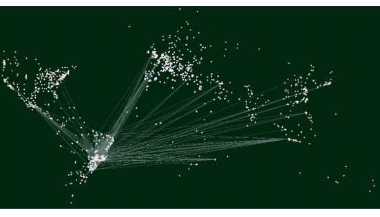
Economic indicators in most developing countries are often outdated. A new study suggests that social media may provide useful economic signals when traditional economic data is unavailable. In “Taking Brazil’s Pulse: Tracking Growing Urban Economies from Online Attention” (PDF), the authors accurately predict the GDPs of 45 Brazilian cities by analyzing data from a popular micro-blogging platform (Yahoo Meme). To make these predictions, the authors used the concept of glocality, which notes that “economically successful cities tend to be involved in interactions that are both local and global at the same time.” The results of the study reveals that “a city’s glocality, measured with social media data, effectively signals the city’s economic well-being.”

The authors are currently expanding their work by predicting social capital for these 45 cities based on social media data. As iRevolution readers will know, I’ve blogged extensively on using social media to measure social capital footprints at the city and sub-city level. So I’ve contacted the authors of the study and look forward to learning more about their research. As they rightly note:

“There is growing interesting in using digital data for development opportunities, since the number of people using social media is growing rapidly in developing countries as well. Local impacts of recent global shocks – food, fuel and financial – have proven not to be immediately visible and trackable, often unfolding ‘beneath the radar of traditional monitoring systems’. To tackle that problem, policymakers are looking for new ways of monitoring local impacts […].”


bio

Predicting the Future of Global Geospatial Information Management

The United Nations Committee of Experts on Global Information Management (GGIM) recently organized a meeting of thought-leaders and visionaries in the geo-spatial world to identify the future of this space over the next 5-10 years. These experts came up with some 80+ individual predictions. I’ve included some of the more interesting ones below.

  • The use of Unmanned Aerial Vehicles (UAVs) as a tool for rapid geospatial data collection will increase.
  • 3D and even 4D geospatial information, incorporating time as the fourth dimension, will increase.
  • Technology will move faster than legal and governance structures.
  • The link between geospatial information and social media, plus other actor networks, will become more and more important.
  • Real-time info will enable more dynamic modeling & response to disasters.
  • Free and open source software will continue to grow as viable alternatives both in terms of software, and potentially in analysis and processing.
  • Geospatial computation will increasingly be non-human consumable in nature, with an increase in fully-automated decision systems.
  • Businesses and Governments will increasingly invest in tools and resources to manage Big Data. The technologies required for this will enable greater use of raw data feeds from sensors and other sources of data.
  • In ten years time it is likely that all smart phones will be able to film 360 degree 3D video at incredibly high resolution by today’s standards & wirelessly stream it in real time.
  • There will be a need for geospatial use governance in order to discern the real world from the virtual/modelled world in a 3D geospatial environ-ment.
  • Free and open access to data will become the norm and geospatial information will increasingly be seen as an essential public good.
  • Funding models to ensure full data coverage even in non-profitable areas will continue to be a challenge.
  • Rapid growth will lead to confusion and lack of clarity over data ownership, distribution rights, liabilities and other aspects.
  • In ten years, there will be a clear dividing line between winning and losing nations, dependent upon whether the appropriate legal and policy frameworks have been developed that enable a location-enabled society to flourish.
  • Some governments will use geospatial technology as a means to monitor or restrict the movements and personal interactions of their citizens. Individuals in these countries may be unwilling to use LBS or applications that require location for fear of this information being shared with authorities.
  • The deployment of sensors and the broader use of geospatial data within society will force public policy and law to move into a direction to protect the interests and rights of the people.
  • Spatial literacy will not be about learning GIS in schools but will be more centered on increasing spatial awareness and an understanding of the value of understanding place as context.
  • The role of National Mapping Agencies as an authoritative supplier of high quality data and of arbitrator of other geospatial data sources will continue to be crucial.
  • Monopolies held by National Mapping Agencies in some areas of specialized spatial data will be eroded completely.
  • More activities carried out by National Mapping Agencies will be outsourced and crowdsourced.
  • Crowdsourced data will push National Mapping Agencies towards niche markets.
  • National Mapping Agencies will be required to find new business models to provide simplified licenses and meet the demands for more free data from mapping agencies.
  • The integration of crowdsourced data with government data will increase over the next 5 to 10 years.
  • Crowdsourced content will decrease cost, improve accuracy and increase availability of rich geospatial information.
  •  There will be increased combining of imagery with crowdsourced data to create datasets that could not have been created affordably on their own.
  • Progress will be made on bridging the gap between authoritative data and crowdsourced data, moving towards true collaboration.
  • There will be an accelerated take-up of Volunteer Geographic Information over the next five years.
  • Within five years the level of detail on transport systems within OpenStreetMap will exceed virtually all other data sources & will be respected/used by major organisations & governments across the globe.
  • Community-based mapping will continue to grow.
  • There is unlikely to be a market for datasets like those currently sold to power navigation and location-based services solutions in 5 years, as they will have been superseded by crowdsourced datasets from OpenStreetMaps or other comparable initiatives.

Which trends have the experts missed? Do you think they’re completely off on any of the above? The full set of predictions on the future of global geospatial information management is available here as a PDF.

Twitter, Crises and Early Detection: Why “Small Data” Still Matters

My colleagues John Brownstein and Rumi Chunara at Harvard Univer-sity’s HealthMap project are continuing to break new ground in the field of Digital Disease Detection. Using data obtained from tweets and online news, the team was able to identify a cholera outbreak in Haiti weeks before health officials acknowledged the problem publicly. Meanwhile, my colleagues from UN Global Pulse partnered with Crimson Hexagon to forecast food prices in Indonesia by carrying out sentiment analysis of tweets. I had actually written this blog post on Crimson Hexagon four years ago to explore how the platform could be used for early warning purposes, so I’m thrilled to see this potential realized.

There is a lot that intrigues me about the work that HealthMap and Global Pulse are doing. But one point that really struck me vis-a-vis the former is just how little data was necessary to identify the outbreak. To be sure, not many Haitians are on Twitter and my impression is that most humanitarians have not really taken to Twitter either (I’m not sure about the Haitian Diaspora). This would suggest that accurate, early detection is possible even without Big Data; even with “Small Data” that is neither representative or indeed verified. (Inter-estingly, Rumi notes that the Haiti dataset is actually larger than datasets typically used for this kind of study).

In related news, a recent peer-reviewed study by the European Commi-ssion found that the spatial distribution of crowdsourced text messages (SMS) following the earthquake in Haiti were strongly correlated with building damage. Again, the dataset of text messages was relatively small. And again, this data was neither collected using random sampling (i.e., it was crowdsourced) nor was it verified for accuracy. Yet the analysis of this small dataset still yielded some particularly interesting findings that have important implications for rapid damage detection in post-emergency contexts.

While I’m no expert in econometrics, what these studies suggests to me is that detecting change-over–time is ultimately more critical than having a large-N dataset, let alone one that is obtained via random sampling or even vetted for quality control purposes. That doesn’t mean that the latter factors are not important, it simply means that the outcome of the analysis is relatively less sensitive to these specific variables. Changes in the baseline volume/location of tweets on a given topic appears to be strongly correlated with offline dynamics.

What are the implications for crowdsourced crisis maps and disaster response? Could similar statistical analyses be carried out on Crowdmap data, for example? How small can a dataset be and still yield actionable findings like those mentioned in this blog post?