Category Archives: Crisis Mapping

Haiti: Lies, Damned Lies and Crisis Mapping

You’d think there was some kind of misinformation campaign going on about the Ushahidi-Haiti Crisis Map given the number of new lies that are still being manu-factured even though it has been over three years since the earthquake. Please, if you really want a professional, independent and rigorous account of the project, read this evaluation. The findings are mixed but the report remains the only comprehensive, professional and independent evaluation of the Ushahidi-Haiti and 4636 efforts. So if you have questions about the project, please read the report and/or contact the evaluators directly.

Screen Shot 2013-02-25 at 2.10.47 AM

In the meantime, I’ve decided to collect the most ridiculous lies & rumors and post my all-time favorites below.

1. “Mission 4636  & Haitian volunteers very strongly opposed the publishing of 4636 SMS’s on the Ushahidi-Haiti Crisis Map given data privacy concerns.”

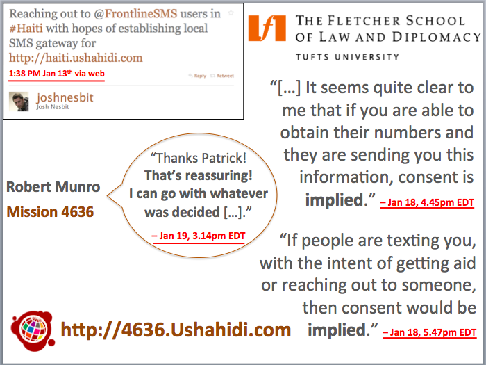
Robert, the person responsible for Mission 4636, agreed (in writing) to publish the SMS’s after two lawyers noted that there was implied consent to make these messages public. The screenshot of the email below clearly proves this. Further-more, he and I co-authored this peer-reviewed study several months after the earthquake to document the lessons learned from the SMS response in Haiti. Surely if one of us had heard about these concerns from the Diaspora, we would have known this and reconsidered the publishing of the SMS’s. We would also have written this up as a major issue in our study. Moreover, the independent and professional evaluators referred to above would also have documented this major issue if it were true.

Screen Shot 2013-02-26 at 9.35.59 AM

I, for one, did not receive a single email from anyone involved in Mission 4636 demanding that the SMS’s not be made public. None of the Boston-based Haitian volunteers who I met in person ever asked for the messages to remain con-fidential; nor did Haitian Diaspora journalists who interviewed us or the many Haitians who called into the radio interviews we participated in ask for the messages to remain secret. Also, the joint decision to (only) map the most urgent and actionable life-and-death messages was supported by a number of humani-tarian colleagues who agreed that the risks of making this information public were minimal vis-à-vis the Do No Harm principle.

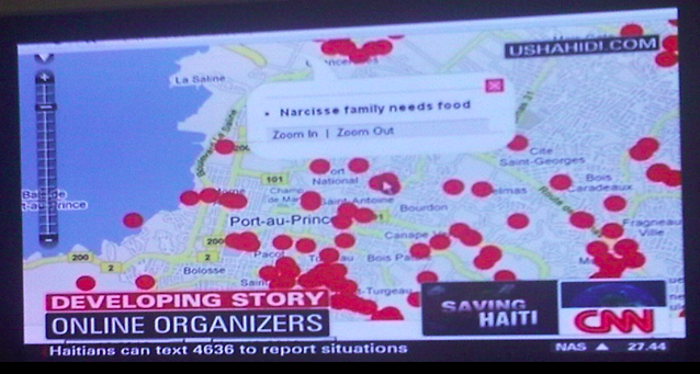
On a practical note, time was a luxury we did not have; an entire week had already passed since the earthquake and we were already at the tail end of the search and rescue phase. This meant that literally every hour counted for potential survivors still trapped under the rubble. There was no time to second-guess the lawyers or to organize workshops on the question. Making the most urgent and actionable life-and-death text messages public meant that the Haitian Diaspora, which was incredibly active in the response, could use that information to help coordinate efforts. NGOs in Haiti could also make use of this information—not to mention the US Marine Corps, which claimed to have saved hundreds of lives thanks to the Ushahidi-Haiti Crisis Map.

Crisis Mapping can be risky business, there’s no doubt about that. Sometimes tough-but-calculated decisions are needed. If one of the two lawyers had opined that the messages should not be made public, then the SMS’s would not have been published, end of story. In any case, the difficulties we faced during this crisis mapping response to Haiti is precisely why I’ve been working hard with GSMA’s Disaster Response Program to create this SMS Code of Conduct. I have also been collaborating directly with the International Committee of the Red Cross (ICRC) to update Data Privacy and Protection Protocols so they include guidelines on social media use and crisis mapping. This new report will be officially launched in Geneva this April followed by a similar event in DC.

2. “Mission 4636 was a completely separate and independent initiative to the Ushahidi Haiti Crisis Map.”

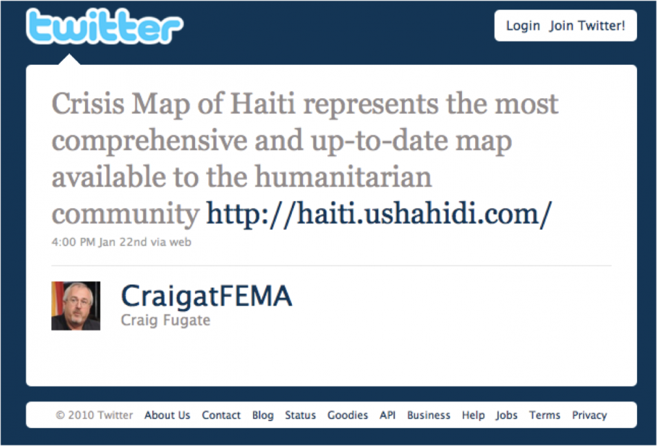
Then why was Josh Nesbit looking for an SMS solution specifically for Ushahidi? The entire impetus for 4636 was the Haiti Crisis Map. Thanks to his tweet, Josh was put in touch with a contact at Digicel Haiti in Port-au-Prince. Several days later, the 4636 short code was set up and integrated with the Ushahidi platform.

jn4636

3. “The microtasking platform developed by Ushahidi to translate the text messages during the first two weeks of operation was built by Tim Schwartz, i.e., not Ushahidi.”

Tim Schwartz is a good friend and wonderful colleague. So when I came across this exciting new rumor, I emailed him right away to thank him: “I’m super surprised since no one ever told me this before. If it is indeed true, then I owe you a huge huge thanks!!” His reply: “Well… not exactly:) Brian [from Ushahidi] took our code from the haitianquake.com and modified it to make the base of 4636. Then I came in and wrote the piece that let volunteers translate missing persons messages and put them into Google Person Finder. Brian definitely wrote the original volunteer part for 4636. He’s the rockstar:)”

4. “Digital Democracy (Dd) developed all the workflows for the Ushahidi-Haiti Crisis Map and also trained the majority of volunteers.”

Dd’s co-founder Emily Jacobi is a close friend and trusted colleague. So I emailed her about this fun new rumor back in October to see if I had somehow missed something. Emily replied: “It’s totally ludicrous to claim that Dd solely set up any of those processes. I do think we played an important role in helping to inform, document & systematize those workflows, which is a world away from claiming sole or even lead ownership of any of it.” Indeed, the workflows kept changing on a daily basis and hundreds of volunteers were trained in person or online–often several times a day. That said, Dd absolutely took the lead in crafting the work-flows & training the bulk of volunteers who spearheaded the Chile Crisis Map. I recommend reading up on Dd’s awesome projects in Haiti and worldwide here.

5. “FEMA Administrator Craig Fugate’s comment below about the Ushahidi Haiti Crisis Map was actually not about the Ushahidi project. Craig was confused and was actually referring to the Humanitarian OpenStreet Map (OSM) of Haiti.”

Again, I was stunned, but in a good way. Kate Chapman, the director of Humani-tarian OpenStreetMap, is a good friend and trusted colleague, so I emailed her the following: “I still hear all kinds of rumors about Haiti but this is the *first* time I’ve come across this one and if this is indeed true then goodness gracious I really need to know so I can give credit where credit is due!” Her reply? She too had never heard this claim before. I trust her 100% so if she ever does tell me that this new rumor is true, I’ll be the first to blog and tweet about it. I’m a huge fan of Humanitarian OpenStreetMap, they really do remarkable work, which is why I included 3 of their projects as case studies in a book chapter I just sub-mitted for publication. In any event, I fully share Kate’s feelings on the rumors: “My feelings on anything that had to do with Haiti is it doesn’t really matter anymore. It has been 2 and a half years. Let’s look on to preparedness and how to improve.” Wise words from a wise woman.

CraigFEMAtweet

6. “Sabina Carlson who acted as the main point of contact between the Ushahidi Haiti project and the Haitian Diaspora also spearheaded the translation efforts and is critical of her Ushahidi Haiti Team members and in particular Patrick Meier for emphasizing the role of international actors and ignoring the Haitian Diaspora.”

This is probably one of the strangest lies yet. Everyone in Boston knows full well that Sabina was not directly focused on translation but rather on outreach and partnership building with the Haitian Diaspora. Sabina, who is a treasured friend, emailed me (out of the blue) when she heard about some of the poisonous rumors circulating. “This was a shock to me,” she wrote, “I would never say anything to put you down, Patrick, and I’m upset that my words were mis-interpreted and used to do just that.” She then detailed exactly how the lie was propagated and by whom (she has the entire transcript).

The fact is this: none of us in Boston ever sought to portray the Diaspora as insignificant or to downplay their invaluable support. Why in the world would we ever do that? Robert and I detailed the invaluable role played by the Diaspora in our peer-reviewed study, for example. Moreover, I invited Sabina to join our Ushahidi-Haiti team precisely because the Diaspora were already responding in amazing ways and I knew they’d stay the course after the end of the emergency phase—we wanted to transfer full ownership of the Haiti Crisis Map to Haitian hands.  In sum, it was crystal clear to every single one of us that Sabina was the perfect person to take on this very important responsibility. She represented the voice and interests of Haitians with incredible agility, determination and intell-igence throughout our many months of work together, both in Boston and Haiti.

bio

Using CrowdFlower to Microtask Disaster Response

Cross-posted from CrowdFlower blog

A devastating earthquake struck Port-au-Prince on January 12, 2010. Two weeks later, on January 27th, a CrowdFlower was used to translate text messages from Haitian Creole to English. Tens of thousands of messages were sent by affected Haitians over the course of several months. All of these were heroically translated by hundreds of dedicated Creole-speaking volunteers based in dozens of countries across the globe. While Ushahidi took the lead by developing the initial translation platform used just days after the earthquake, the translation efforts were eventually rerouted to CrowdFlower. Why? Three simple reasons:

  1. CrowdFlower is one of the leading and most highly robust micro-tasking platforms there is;
  2. CrowdFlower’s leadership is highly committed to supporting digital humanitarian response efforts;
  3. Haitians in Haiti could now be paid for their translation work.

While the CrowdFlower project was launched 15 days after the earthquake, i.e., following the completion of search and rescue operations, every single digital humanitarian effort in Haiti was reactive. The key takeaway here was the proof of concept–namely that large-scale micro-tasking could play an important role in humanitarian information management. This was confirmed months later when devastating floods inundated much of Pakistan. CrowdFlower was once again used to translate incoming messages from the disaster affected population. While still reactive, this second use of CrowdFlower demonstrated replicability.

The most recent and perhaps most powerful use of CrowdFlower for disaster response occurred right after Typhoon Pablo devastated the Philippines in early December 2012. The UN Office for the Coordination of Humanitarian Affairs (OCHA) activated the Digital Humanitarian Network (DHN) to rapidly deliver a detailed dataset of geo-tagged pictures and video footage (posted on Twitter) depicting the damage caused by the Typhoon. The UN needed this dataset within 12 hours, which required that 20,000 tweets to be analyzed as quickly as possible. The Standby Volunteer Task Force (SBTF), a member of Digital Huma-nitarians, immediately used CrowdFlower to identify all tweets with links to pictures & video footage. SBTF volunteers subsequently analyzed those pictures and videos for damage and geographic information using other means.

This was the most rapid use of CrowdFlower following a disaster. In fact, this use of CrowdFlower was pioneering in many respects. This was the first time that a member of the Digital Humanitarian Network made use of CrowdFlower (and thus micro-tasking) for disaster response. It was also the first time that Crowd-Flower’s existing workforce was used for disaster response. In addition, this was the first time that data processed by CrowdFlower contributed to an official crisis map produced by the UN for disaster response (see above).

These three use-cases, Haiti, Pakistan and the Philippines, clearly demonstrate the added value of micro-tasking (and hence CrowdFlower) for disaster response. If CrowdFlower had not been available in Haiti, the alternative would have been to pay a handful of professional translators. The total price could have come to some $10,000 for 50,000 text messages (at 0.20 cents per word). Thanks to CrowdFlower, Haitians in Haiti were given the chance to make some of that money by translating the text messages themselves. Income generation programs are absolutely critical to rapid recovery following major disasters. In Pakistan, the use of CrowdFlower enabled Pakistani students and the Diaspora to volunteer their time and thus accelerate the translation work for free. Following Typhoon Pablo, paid CrowdFlower workers from the Philippines, India and Australia categorized several thousand tweets in just a couple hours while the volunteers from the Standby Volunteer Task Force geo-tagged the results. Had CrowdFlower not been available then, it is highly, highly unlikely that the mission would have succeeded given the very short turn-around required by the UN.

While impressive, the above use-cases were also reactive. We need to be a lot more pro-active, which is why I’m excited to be collaborating with CrowdFlower colleagues to customize a standby platform for use by the Digital Humanitarian Network. Having a platform ready-to-go within minutes is key. And while digital volunteers will be able to use this standby platform, I strongly believe that paid CrowdFlower workers also have a key role to play in the digital huma-nitarian ecosystem. Indeed, CrowdFlower’s large, multinational and multi-lingual global workforce is simply unparalleled and has the distinct advantage of being very well versed in the CrowdFlower platform.

In sum, it is high time that the digital humanitarian space move from crowd-sourcing to micro-tasking. It has been three years since the tragic earthquake in Haiti but we have yet to adopt micro-tasking more widely. CrowdFlower should thus play a key role in promoting and enabling this important shift. Their con-tinued important leadership in digital humanitarian response should also serve as a model for other private sector companies in the US and across the globe.

bio

Launching: SMS Code of Conduct for Disaster Response

Shortly after the devastating Haiti Earthquake of January 12, 2010, I published this blog post on the urgent need for an SMS code of conduct for disaster response. Several months later, I co-authored this peer-reviewed study on the lessons learned from the unprecedented use of SMS following the Haiti Earth-quake. This week, at the Mobile World Congress (MWC 2013) in Barcelona, GSMA’s Disaster Response Program organized two panels on mobile technology for disaster response and used the event to launch an official SMS Code of Conduct for Disaster Response (PDF). GSMA members comprise nearly 800 mobile operators based in more than 220 countries.

Screen Shot 2013-02-18 at 2.27.32 PM

Thanks to Kyla Reid, Director for Disaster Response at GSMA, and to Souktel’s Jakob Korenblummy calls for an SMS code of conduct were not ignored. The three of us spent a considerable amount of time in 2012 drafting and re-drafting a detailed set of principles to guide SMS use in disaster response. During this process, we benefited enormously from many experts on the mobile operators side and the humanitarian community; many of whom are at MWC 2013 for the launch of the guidelines. It is important to note that there have been a number of parallel efforts that our combined work has greatly benefited from. The Code of Conduct we launched this week does not seek to duplicate these important efforts but rather serves to inform GSMA members about the growing importance of SMS use for disaster response. We hope this will help catalyze a closer relationship between the world’s leading mobile operators and the international humanitarian community.

Since the impetus for this week’s launch began in response to the Haiti Earth-quake, I was invited to reflect on the crisis mapping efforts I spearheaded at the time. (My slides for the second panel organized by GSMA are available here. My more personal reflections on the 3rd year anniversary of the earthquake are posted here). For several weeks, digital volunteers updated the Ushahidi-Haiti Crisis Map (pictured above) with new information gathered from hundreds of different sources. One of these information channels was SMS. My colleague Josh Nesbit secured an SMS short code for Haiti thanks to a tweet he posted at 1:38pm on Jan 13th (top left in image below). Several days later, the short code (4636) was integrated with the Ushahidi-Haiti Map.

Screen Shot 2013-02-18 at 2.40.09 PM

We received about 10,000 text messages from the disaster-affected population during the during the Search and Rescue phase. But we only mapped about 10% of these because we prioritized the most urgent and actionable messages. While mapping these messages, however, we had to address a critical issue: data privacy and protection. There’s an important trade-off here: the more open the data, the more widely useable that information is likely to be for professional disaster responders, local communities and the Diaspora—but goodbye privacy.

Time was not a luxury we had; an an entire week had already passed since the earthquake. We were at the tail end of the search and rescue phase, which meant that literally every hour counted for potential survivors still trapped under the rubble. So we immediately reached out to 2 trusted lawyers in Boston, one of them a highly reputable Law Professor at The Fletcher School of Law and Diplomacy who also a specialist on Haiti. You can read the lawyers’ written email replies along with the day/time they were received on the right-hand side of the slide. Both lawyers opined that consent was implied vis-à-vis the publishing of personal identifying information. We shared this opinion with all team members and partners working with us. We then made a joint decision 24 hours later to move ahead and publish the full content of incoming messages. This decision was supported by an Advisory Board I put together comprised of humanitarian colleagues from the Harvard Humanitarian Initiative who agreed that the risks of making this info public were minimal vis-à-vis the principle of Do No HarmUshahidi thus launched a micro-tasking platform to crowdsource the translation efforts and hosted this on 4636.Ushahidi.com [link no longer live], which volunteers from the Diaspora used to translate the text messages.

I was able to secure a small amount of funding in March 2010 to commission a fully independent evaluation of our combined efforts. The project was evaluated a year later by seasoned experts from Tulane University. The results were mixed. While the US Marine Corps publicly claimed to have saved hundreds of lives thanks to the map, it was very hard for the evaluators to corroborate this infor-mation during their short field visit to Port-au-Prince more than 12 months after the earthquake. Still, this evaluation remains the only professional, independent and rigorous assessment of Ushahidi and 4636 to date.

Screen Shot 2013-02-25 at 2.10.47 AM

The use of mobile technology for disaster response will continue to increase for years to come. Mobile operators and humanitarian organizations must therefore be pro-active in managing this increase demand by ensuring that the technology is used wisely. I, for one, never again want to spend 24+ precious hours debating whether or not urgent life-and-death text messages can or cannot be mapped because of uncertainties over data privacy and protection—24 hours during a Search and Rescue phase is almost certain to make the difference between life and death. More importantly, however, I am stunned that a bunch of volunteers with little experience in crisis response and no affiliation whatsoever to any established humanitarian organization were able to secure and use an official SMS short code within days of a major disaster. It is little surprise that we made mistakes. So a big thank you to Kyla and Jakob for their leadership and perseverance in drafting and launching GSMA’s official SMS Code of Conduct to make sure the same mistakes are not made again.

While the document we’ve compiled does not solve every possible challenge con-ceivable, we hope it is seen as a first step towards a more informed and responsible use of SMS for disaster response. Rest assured that these guidelines are by no means written in stone. Please, if you have any feedback, kindly share them in the comments section below or privately via email. We are absolutely committed to making this a living document that can be updated.

To connect this effort with the work that my CrisisComputing Team and I are doing at QCRI, our contact at Digicel during the Haiti response had given us the option of sending out a mass SMS broadcast to their 2 million subscribers to get the word out about 4636. (We had thus far used local community radio stations). But given that we were processing incoming SMS’s manually, there was no way we’d be able to handle the increased volume and velocity of incoming text messages following the SMS blast. So my team and I are exploring the use of advanced computing solutions to automatically parse and triage large volumes of text messages posted during disasters. The project, which currently uses Twitter, is described here in more detail.

bio

Social Media as Passive Polling: Prospects for Development & Disaster Response

My Harvard/MIT colleague Todd Mostak wrote his award-winning Master’s Thesis on “Social Media as Passive Polling: Using Twitter and Online Forums to Map Islamism in Egypt.” For this research, Todd evaluated the “potential of Twitter as a source of time-stamped, geocoded public opinion data in the context of the recent popular uprisings in the Middle East.” More specifically, “he explored three ways of measuring a Twitter user’s degree of political Islamism.” Why? Because he wanted to test the long-standing debate on whether Islamism is associated with poverty.

Screen Shot 2013-02-18 at 11.17.09 AM

So Todd collected millions of geo-tagged tweets from Egypt over a six month period, which he then aggregated by census district in order to regress proxies for poverty against measures of Islamism drived from the tweets and the users’ social graphs. His findings reveal that “Islamist sentiment seems to be positively correlated with male unemployment, illiteracy, and percentage of land used in agriculture and negatively correlated with percentage of men in their youth aged 15-25. Note that female variables for unemployment and age were statistically insignificant.” As with all research, there are caveats such as the weighting scale used for the variables and questions over the reliability of census variables.

Screen Shot 2013-02-18 at 11.15.59 AM

To carry out his graduate research, Todd built a web-enabled database (MapD) powered by a Graphics Processing Units (GPU) to perform real-time querying and visualization of big datasets. He is now working with Harvard’s Center for Geographic Analysis (CGA) to put make this available via a public web interface called Tweetmap. This Big Data streaming and exploration tool presen-tly displays 119 million tweets from 12/10/2012 to 12/31/2012. He is adding 6-7 million new georeferenced tweets per day (but these are not yet publicly available on Tweetmap). According to Todd, the time delay from live tweet to display on the map is about 1 second. Thanks to this GPU-powered approach, he expects that billions of tweets could be displayed in real-time.

Screen Shot 2013-02-18 at 11.14.02 AM

As always with impressive projects, no one single person was behind the entire effort. Ben Lewis, who heads the WorldMap initiative at CGA deserves a lot of credit for making Tweetmap a reality. Indeed, Todd collaborated directly with CGA’s Ben Lewis throughout this project and benefited extensively from his expertise. Matt Bertrand (lead developer for CGA) did the WorldMap-side integration of MapD to create the TweetMap interface.

Todd and I recently spoke about integrating his outstanding work on automated live mapping to QCRI’s Twitter Dashboard for Disaster Response. Exciting times. In the meantime, Todd has kindly shared his dataset of 700+ million geotagged tweets for my team and I to analyze. The reason I’m excited about this approach is best explained with this heatmap of the recent snow-storm in the northeastern US. Todd is already using Tweetmap for live crisis mapping. While this system filters by keyword, our Dashboard will use machine learning to provide more specific streams of relevant tweets, some of which could be automatically mapped on Tweetmap. See Todd’s Flickr page for more Tweetmap visuals.

Screen Shot 2013-02-18 at 11.30.54 AM

I’m also excited by Todd’s GPU-powered approach for a project I’m exploring with UN and World Bank colleagues. The purpose of that research project is to determine whether socio-economic trends such as poverty and unemployment can be captured via Twitter. Our first case study is Egypt. Depending on the results, we may be able to take it one step further by applying sentiment analysis to real-time, georeferenced tweets to visualize Twitter users’ per-ception vis-a-vis government services—a point of interest for my UN colleagues in Cairo.

bio

Video: Minority Report Meets Crisis Mapping

This short video was inspired by the pioneering work of the Standby Volunteer Task Force (SBTF). A global network of 1,000+ digital humanitarians in 80+ countries, the SBTF is responsible for some of the most important live crisis mapping operations that have supported both humanitarian and human rights organizations over the past 2+ years. Today, the SBTF is a founding and active member of the Digital Humanitarian Network (DHN) and remains committed to rapid learning and innovation thanks to an outstanding team of volunteers (“Mapsters”) and their novel use of next-generation humanitarian technologies.

The video first aired on the National Geographic Television Channel in February 2013. A big thanks to the awesome folks from National Geographic and the outstanding Evolve Digital Cinema Team for visioning the future of digital humanitarian technologies—a future that my Crisis Computing Team and I at QCRI are working to create.

An aside: I tried on several occasions to hack the script and say “We” rather than “I” since crisis mapping is very rarely a solo effort but the main sponsor insisted that the focus be on one individual. On the upside, one of the scenes in the commercial is of a Situation Room full of Mapsters coupled with the narration: “Our team can map the pulse of the planet, from anywhere, getting aid to the right places.” Our team = SBTF! Which is why the $$ received for being in this commercial will go towards supporting Mapsters.

bio

Map or Be Mapped: Otherwise You Don’t Exist

“There are hardly any street signs here. There are no official zip codes. No addresses. Just word of mouth” (1). Such is the fate of Brazil’s Mare shanty-town and that of most shantytowns around the world where the spoken word is king (and not necessarily benevolent). “The sprawling complex of slums, along with the rest of Rio de Janerio’s favelas, has hung in a sort of ‘legal invisibility’ since 1937, when a city ordinance ruled that however unsightly, favelas should be kept off maps because they were merely ‘temporary'” (2).

shantytown

The socio-economic consequences were far-reaching. For decades, this infor-mality meant that “entire neighborhoods did not receive mail. It had also blocked people from giving required information on job applications, getting a bank account or telling the police or fire department where to go in an emergency call. Favela residents had to pick up their mail from their neighborhood associations, and entire slums housing a small town’s worth of residents had to use the zip code of the closest officially recognized street” (3).

All this is starting to change thanks to a grassroots initiative that is surveying Mare’s 16 favelas, home to some 130,000 people. This community-driven project has appropriated the same survey methodology used by the Brazilian government’s Institute of Geography and Statistics. The collected data includes “not only street names but the history of the original smaller favelas that make up the community” (4). This data is then “formatted into pocket guides and distributed gratis to residents. These guides also offer background on certain streets’ namesakes, but leave some blank so that residents can fill them in as Mare […] continues shifting out from the shadows of liminal space to a city with distinct identities” (5). And so, “residents of Rio’s famed favelas are undergoing their first real and ‘fundamental step toward citizenship'” (6).

These bottom-up, counter-mapping efforts are inherently political—call it guerrilla mapping. Traditionally, maps have represented “not just the per-spective of the cartographer herself, but of much larger institutions—of corporations, organizations, and governments” (7). The scale was fixed at one and only one scale, that of the State. Today, informal communities can take matters into their own hands and put themselves on the map; at the scale of their choosing. But companies like Google still have the power to make these communities vanish. In Brazil, Google said it “would tweak the site’s [Google Maps’] design, namely its text size and district labeling to show favela names only after users zoomed in on those areas.”

GmapNK

Meanwhile, Google is making North Korea’s capital city more visible. But I had an uncomfortable feeling after reading National Geographic’s take on Google’s citizen mapping expedition to North Korea. The Director for National Geographic Maps, Juan José Valdéscautions that, “In many parts of the world such citizen mapping has proven challenging, if not downright dangerous. In many places, little can be achieved without the approval of local and or national authorities—especially in North Korea.” Yes, but in many parts of the world citizen mapping is safe and possible. More importantly, citizen mapping can be a powerful tool for digital activism. My entire doctoral dissertation focuses on exactly this issue.

Yes, Valdés is absolutely correct when he writes that “In many countries, place-names, let alone the alignment of boundaries, remain a powerful symbol of independence and national pride, and not merely indicators of location. This is where citizen cartographers need to understand the often subtle nuances and potential pitfalls of mapping.” As the New Yorker notes, “Maps are so closely associated with power that dictatorships regard information on geography as a state secret.” But map-savvy digital activists already know this better than most, and they deliberately seek to exploit this to their advantage in their struggles for democracy.

National Geographic’s mandate is of course very different. “From National Geographic’s perspective, all a map should accomplish is the actual portrayal of national sovereignty, as it currently exists. It should also reflect the names as closely as possible to those recognized by the political entities of the geographic areas being mapped. To do otherwise would give map readers an unrealistic picture of what is occurring on the ground.”

natgeomaps

This makes perfect sense for National Geographic. But as James Scott reminds us in his latest book, “A great deal of the symbolic work of official power is precisely to obscure the confusion, disorder, spontaneity, error, and improvisation of political power as it is in fact exercised, beneath a billiard-ball-smooth surface of order, deliberation, rationality, and control. I think of this as the ‘miniaturization of order.'” Scott adds that, “The order, rationality, abstractness and synoptic legibility of certain kinds of schemes of naming, landscape, architecture, and work processes lend themselves to hierarchical power […] ‘landscapes of control and appropriation.'”

Citizen mapping, especially in repressive environments, often seeks to change that balance of power by redirecting the compass of political power with the  use of subversive digital maps. Take last year’s example of Syrian pro-democracy activists changing place & street names depicted on on the Google Map of Syria. They did this intentionally as an act of resistance and defiance. Again, I fully understand and respect that National Geographic’s mandate is completely different to that of pro-democracy activists fighting for freedom. I just wish that Valdés had a least added one sentence to acknowledge the importance of maps for the purposes of resistance and pro-democracy movements. After all, he is himself a refugee from Cuba’s political repression.

There is of course a flip side to all this. While empowering, visibility and legibility can also undermine a community’s autonomy. As Pierre-Joseph Proudhon famously put it, “To be governed is to be watched, inspected, spied upon, directed, law-driven, numbered, regulated, enrolled, indoctrinated, preached at, controlled, checked, estimated, valued, censured, commanded, by creatures who have neither the right nor the wisdom nor the virtue to do so.” To be digitally mapped is to be governed, but perhaps at multiple scales including the preferred scale of self-governance and self-determination.

And so, we find ourselves repeating the words of Shakespeare’s famous character Hamlet: “To be, or not to be,” to map, or not to map.


See also:

  • Spying with Maps [Link]
  • How to Lie With Maps [Link]
  • Folksomaps for Community Mapping [Link]
  • From Social Mapping to Crisis Mapping [Link]
  • Crisis Mapping Somalia with the Diaspora [Link]
  • Perils of Crisis Mapping: Lessons from Gun Map [Link]
  • Crisis Mapping the End of Sudan’s Dictatorship? [Link]
  • Threat and Risk Mapping Analysis in the Sudan [Link]
  • Rise of Amateur Professionals & Future of Crisis Mapping [Link]
  • Google Inc + World Bank = Empowering Citizen Cartographers? [Link]

Note: Readers interested in the topics discussed above may also be interested in a forthcoming book to be published by Oxford University Press entitled “Information and Communication Technologies in Areas of Limited State-hood.” I have contributed a chapter to this book entitled “Crisis Mapping in Areas of Limited Statehood,” which analyzes how the rise of citizen-genera-ted crisis mapping replaces governance in areas of limited statehood. The chapter distills the conditions for the success of these crisis mapping efforts in these non-permissive and resource-restricted environments. 

Perils of Crisis Mapping: Lessons from Gun Map

Any CrisisMapper who followed the social firestorm surrounding the gun map published by the Journal News will have noted direct parallels with the perils of Crisis Mapping. The digital and interactive gun map displayed the (lega-lly acquired) names and addresses of 33,614 handgun permit holders in two counties of New York. Entitled “The Gun Owner Next Door,” the project was launched on December 23, 2012 to highlight the extent of gun proliferation in the wake of the school shooting in Newtown. The map has been viewed over 1 million times since. This blog post documents the consequences of the gun map and explains how to avoid making the same mistakes in the field of Crisis Mapping.

gunmap

The backlash against Journal News was swift, loud and intense. The interactive map included the names and addresses of police officers and other law enforcement officials such as prison guards. The latter were subsequently threatened by inmates who used the map to find out exactly where they lived. Former crooks and thieves confirmed the map would be highly valuable for planning crimes (“news you can use”). They warned that criminals could easily use the map either to target houses with no guns (to avoid getting shot) or take the risk and steal the weapons themselves. Shotguns and hand-guns have a street value of $300-$400 per gun. This could lead to a proliferation of legally owned guns on the street.

The consequences of publishing the gun map didn’t end there. Law-abiding citizens who do not own guns began to fear for their safety. A Democratic legislator told the media: “I never owned a gun but now I have no choice […]. I have been exposed as someone that has no gun. And I’ll do anything, anything to protect my family.” One resident feared that her ex-husband, who had attempted to kill her in the past, might now be able to find her thanks to the map. There were also consequences for the journalists who published the map. They began to receive death threats and had to station an armed guard outside one of their offices. One disenchanted blogger decided to turn the tables (reverse panopticon) by publishing a map with the names and addresses of key editorial staffers who work at  Journal News. The New York Times reported that the location of the editors’ children’s schools had also been posted online. Suspicious packages containing white powder were also mailed to the newsroom (later found to be harmless).

News about a burglary possibly tied to the gun map began to circulate (although I’m not sure whether the link was ever confirmed). But according to one report, “said burglars broke in Saturday evening, and went straight for the gun safe. But they could not get it open.” Even if there was no link between this specific burglary and the gun map, many county residents fear that their homes have become a target. The map also “demonized” gun owners.

gunmap2

After weeks of fierce and heated “debate” the Journal News took the map down. But were the journalists right in publishing their interactive gun map in the first place? There was nothing illegal about it. But should the map have been published? In my opinion: No. At least not in that format. The rationale behind this public map makes sense. After all, “In the highly charged debate over guns that followed the shooting, the extent of ownership was highly relevant. […] By publishing the ‘gun map,’ the Journal News gave readers a visceral understanding of the presence of guns in their own community.” (Politico). It was the implementation of the idea that was flawed.

I don’t agree with the criticism that suggests the map was pointless because criminals obviously don’t register their guns. Mapping criminal activity was simply not the rationale behind the map. Also, while Journal News could simply have published statistics on the proliferation of gun ownership, the impact would not have been as … dramatic. Indeed, “ask any editor, advertiser, artist or curator—hell, ask anyone whose ever made a PowerPoint presentation—which editorial approach would be a more effective means of getting the point across” (Politico). No, this is not an endorsement of the resulting map, simply an acknowledgement that the decision to use mapping as a medium for data visualization made sense.

The gun map could have been published without the interactive feature and without corresponding names and addresses. This is eventually what the jour-nalists decided to do, about four weeks later. Aggregating the statistics would have also been an option in order to get away from individual dots representing specific houses and locations. Perhaps a heat map that leaves enough room for geographic ambiguity would have been less provocative but still effective in de-picting the extent of gun proliferation. Finally, an “opt out” feature should have been offered, allowing those owning guns to remove themselves from the map (still in the context of a heat map). Now, these are certainly not perfect solutions—simply considerations that could mitigate some of the negative consequences that come with publishing a hyper-local map of gun ownership.

The point, quite simply, is that there are various ways to map sensitive data such that the overall data visualization is rendered relatively less dangerous. But there is another perhaps more critical observation that needs to be made here. The New York Time’s Bill Keller gets to the heart of the matter in this piece on the gun map:

“When it comes to privacy, we are all hypocrites. We howl when a newspaper publishes public records about personal behavior. At the same time, we are acquiescing in a much more sweeping erosion of our privacy —government surveillance, corporate data-mining, political micro-targeting, hacker invasions—with no comparable outpouring of protest. As a society we have no coherent view of what information is worth defending and how to defend it. When our personal information is exploited this way, we may grumble, or we may seek the largely false comfort of tweaking our privacy settings […].”

In conclusion, the “smoking guns” (no pun intended) were never found. Law enforcement officials and former criminals seemed to imply that thieves would go on a rampage with map in hand. So why did we not see a clear and measurable increase in burglaries? The gun map should obviously have given thieves the edge. But no, all we have is just one unconfirmed report of an unsuccessful crime that may potentially be linked to the map. Surely, there should be an arsenal of smoking guns given all the brouhaha.

In any event, the controversial gun map provides at least six lessons for those of us engaged in crisis mapping complex humanitarian emergencies:

First, just because data is publicly-accessible does not mean that a map of said data is ethical or harmless. Second, there are dozens of ways to visualize and “blur” sensitive data on a map. Third, a threat and risk mitigation strategy should be standard operating procedure for crisis maps. Fourth, since crisis mapping almost always entails risk-taking when tracking conflicts, the benefits that at-risk communities gain from the resulting map must always and clearly outweigh the expected costs. This means carrying out a Cost Benefit Analysis, which goes to the heart of the “Do No Harm” principle. Fifth, a code of conduct on data protection and data security for digital humanitarian response needs to be drafted, adopted and self-enforced; something I’m actively working on with both the International Committee of the Red Cross (ICRC) and GSMA’s  Disaster Response Program. Sixth, the importance of privacy can—and already has—been hijacked by attention-seeking hypocrites who sensationalize the issue to gain notoriety and paralyze action. Non-action in no way implies no-harm.

Update: Turns out the gan ownership data was highly inaccurate!

See also:

  • Does Digital Crime Mapping Work? Insights on Engagement, Empowerment & Transparency [Link]
  • On Crowdsourcing, Crisis Mapping & Data Protection [Link]
  • What do Travel Guides and  Nazi Germany have to do with Crisis Mapping and Security? [Link]

Personal Reflections: 3 Years After the Haiti Earthquake

The devastating earthquake that struck Port-au-Prince on January 12, 2010 killed as many as 200,000 people. My fiancée and five close friends were in Haiti at the time and narrowly escaped a collapsing building. They were some of the lucky few survivors. But I had no knowledge that they had survived until 8 hours or so after the earthquake because we were unable get any calls through. The Haiti Crisis Map I subsequently spearheaded still stands as the most psycho-logically and emotionally difficult project I’ve ever been a part of.

The heroes of this initiative and the continuing source of my inspiration today were the hundreds and hundreds of volunteers who ensured the Haiti Crisis Map remained live for so many weeks. The majority of these volunteers were of course the Haitian Diaspora as well as Haitians in country. I had the honor of meeting and working with one of these heroes while in Port-au-Prince, Kurt Jean-Charles, the CEO of the Haitian software company Solutions.ht. I invited Kurt to give the Keynote at the 2010 International Crisis Mappers Conference (ICCM 2010) and highly recommend watching the video above. Kurt speaks directly from the heart.

HaitianDiaspora

Another personal hero of mine (pictured above) is Sabina Carlson—now Sabina Carlson Robillard following her recent wedding to Louino in Port-au-Prince! She volunteered as the Haitian Diaspora Liaison for the Haiti Crisis Map and has been living in Cité Soleil ever since. Needless to say, she continues to inspire all of us who have had the honor of working with her and learning from her.

Finally, but certainly not (!) least, the many, many hundreds of amazing volun-teers who tirelessly translated tens of thousands of text messages for this project. Thanks to you, some 1,500 messages from the disaster-affected population were added to the live crisis map of Haiti. This link points to the only independent, rigorous and professional evaluation of the project that exists. I highly reco-mmend reading this report as it comprises a number of important lessons learned in crisis mapping and digital humanitarian response.

Fonkoze

In the meantime, please consider making a donation to Fonkoze, an outstanding local organization committed to the social and economic improvement of the Haitian poor. Fonkoze is close to my heart not only because of the great work that they do but also because its staff and CEO were the ones who ensured the safe return of my fiancée and friends after the earthquake. In fact, my fiancée has continued to collaborate with them ever since and still works on related projects in Haiti. She is headed back to Port-au-Prince this very weekend. To make a tax deductible donation to Fonkoze, please visit this link. Thank you.

My thoughts & prayers go out to all those who lost loved ones in Haiti years ago.

What Waze Can Teach Us About Crowdsourcing and Crisis Mapping

I recently tried out Waze, “the world’s fastest-growing community-based traffic and navigation app.” The smart phone app enables drivers to easily share real-time traffic and road information, “saving everyone time and gas money on their daily commute.” Waze is quite possibly the most successful live, crowdsourced mapping platform there is. Over 30 million drivers use the app to “outsmart traffic and get everyone the best route to work and back, every day.”

Why is Waze so successful? Because the creators of this app recognize full well that “Traffic is more than just red lines on the map.” Likewise, Crisis Mapping is also more than just dots on the map. But unlike Waze, groups like Ushahidi have not adopted dynamic geo-fencing features (despite my best efforts back in 2011). With Waze, drivers get automatically alerted before they approach police, accidents, road hazards or traffic jams, all shared by other drivers in real time. “It’s like a personal heads-up from a few million of your friends on the road.” The creators of Waze have also integrated gaming and social networking features into their app, something I also lobbied Ushahidi to do years ago. Not only is updating Waze super easy and fast to update, it is also fun and rewarding—which reminds me of the “Fisher Price Theory of Crisis Mapping.”

Just like drivers on the motorway, humanitarians do not have the time to keep watching and analyzing dots on a map. They have to keep their hands “on the wheel” and focus on the more important tasks at hand. Crisis Mapping platforms therefore have to be hands-free and more voice-based to limit the distraction of tactile data entry. In other words, the interface needs to become invisible. As computing pioneer Mark Weiser noted, “The best technology should be invisible, get out of your way, and let you live your life.” My colleague Amber Case add that “We shouldn’t have to fiddle with interfaces. We should be humans; machines should be machines; each amplifying the best of both. Wouldn’t that make for a nice reality?” This is what Waze is doing by integrating very neat user-interface features and voice-based controls, which improve situational awareness and facilitates real-time decision-making.

In conclusion, Waze’s clever user-centered design features are also relevant to map-based development and human rights projects in the majority world (i.e. developing countries). Otherwise, the value of digital maps is more like that of news articles—that is, informative but not necessarily operational and actionable for local decision-making purposes.

bio

See also: Waze Helps Drivers Get Around Damage from Oklahoma Tornadoes

How Can Digital Humanitarians Best Organize for Disaster Response?

My colleague Duncan Watts recently spoke with Scientific American about a  new project I am collaborating on with him & colleagues at Microsoft Research. I first met Duncan while at the Santa Fe Institute (SFI) back in 2006. We recently crossed paths again (at 10 Downing Street, of all places), and struck up a conver-sation about crisis mapping and the Standby Volunteer Task Force (SBTF). So I shared with him some of the challenges we were facing vis-a-vis the scaling up of our information processing workflows for digital humanitarian response. Duncan expressed a strong interest in working together to address some of these issues. As he told Scientific American, “We’d like to help them by trying to understand in a more scientific manner how to scale up information processing organizations like the SBTF without over-loading any part of the system.”

Scientific American Title

Here are the most relevant sections of his extended interview:

In addition to improving research methods, how might the Web be used to deliver timely, meaningful research results?

Recently, a handful of volunteer “crisis mapping” organizations such as The Standby Task Force [SBTF] have begun to make a difference in crisis situations by performing real-time monitoring of information sources such as Facebook, Twitter and other social media, news reports and so on and then superposing these reports on a map interface, which then can be used by relief agencies and affected populations alike to improve their under-standing of the situation. Their efforts are truly inspiring, and they have learned a lot from experience. We want to build off that real-world model through Web-based crisis-response drills that test the best ways to comm-unicate and coordinate resources during and after a disaster.

How might you improve upon existing crisis-mapping efforts?

The efforts of these crisis mappers are truly inspiring, and groups like the SBTF have learned a lot about how to operate more effectively, most from hard-won experience.  At the same time, they’ve encountered some limita-tions to their model, which depends critically on a relatively small number of dedicated individuals, who can easily get overwhelmed or burned out. We’d like to help them by trying to understand in a more scientific manner how to scale up information processing organizations like the SBTF without over-loading any part of the system.

How would you do this in the kind of virtual lab environment you’ve been describing?

The basic idea is to put groups of subjects into simulated crisis-mapping drills, systematically vary different ways of organizing them, and measure how quickly and accurately they collectively process the corresponding information. So for any given drill, the organizer would create a particular disaster scenario, including downed power lines, fallen trees, fires and flooded streets and homes. The simulation would then generate a flow of information, like a live tweet stream that resembles the kind of on-the-ground reporting that occurs in real events, but in a controllable way.

As a participant in this drill, imagine you’re monitoring a Twitter feed, or some other stream of reports, and that your job is to try to accurately recreate the organizer’s disaster map based on what you’re reading. So for example, you’re looking at Twitter feeds for everything during hurricane Sandy that has “#sandy” associated with it. From that information, you want to build a map of New York and the tri-state region that shows everywhere there’s been lost power, everywhere there’s a downed tree, everywhere where there’s a fire.

You could of course try to do this on your own, but as the rate of infor-mation flow increased, any one person would get overwhelmed; so it would be necessary to have a group of people working on it together. But depen-ding on how the group is organized, you could imagine that they’d do a better or worse job, collectively. The goal of the experiment then would be to measure the performance of different types of organizations—say with different divisions of labor or different hierarchies of management—and discover which work better as a function of the complexity of the scenario you’ve presented and the rate of information being generated. This is something that we’re trying to build right now.

What’s the time frame for implementing such crowdsourced disaster mapping drills?

We’re months away from doing something like this. We still need to set up the logistics and are talking to a colleague [Patrick Meier] who works as a crisis mapper to get a better understanding of how they do things so that we can design the experiment in a way that is motivated by a real problem.

How will you know when your experiments have created something valuable for better managing disaster responses?

There’s no theory that says, here’s the best way to organize n people to process the maximum amount of information reliably. So ideally we would like to design an experiment that is close enough to realistic crisis-mapping scenarios that it could yield some actionable insights. But the experiment would also need to be sufficiently simple and abstract so that we learn something about how groups of people process information that generalizes beyond the very specific case of crisis mapping.

As a scientist, I want to identify causal mechanisms in a nice, clean way and reduce the problem to its essence. But as someone who cares about making a difference in the real world, I would also like to be able to go back to my friend who’s a crisis mapper and say we did the experiment, and here’s what the science says you should do to be more effective.

The full interview is available at Scientific AmericanStay tuned for further up-dates on this research.