Category Archives: Drones/UAVs

Pictures: Humanitarian UAV Mission to Vanuatu in Response to Cyclone Pam

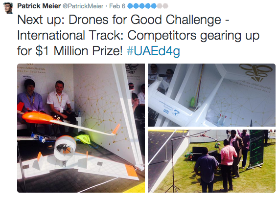
Aéroport de Port Vila – Bauerfield International Airport. As we land, thousands of uprooted trees could be seen in almost every direction.

WP1

Massive roots were not enough to save these trees from Cyclone Pam. The devastation reminds us how powerful nature is.

WP2

WP3

WP4

After getting clearance from the Australian Defense Force (ADF), we pack up our UAVs and head over to La Lagune for initial tests. Close collaboration with the military is an absolute must for humanitarian UAV missions. UAVs cannot operate in Restricted Operations Zones without appropriate clearance.

WP5

We’re in Vanuatu by invitation of the Government’s National Disaster Risk Management Office (NDMO). So we’re working very closely with our hosts to assess disaster damage and resulting needs. The government and donors need the damage quantified to assess how much funding is necessary for the recovery efforts; and where geographically that funding should be targeted.

WP6

Ceci n’est pas un drone; what we found at La Lagune, where the ADF has set up camp. At 2200 every night we send the ADF our flight plan clearance requests for the following day. For obvious safety reasons, we never deviate from these plans after they’ve been approved.

WP6b

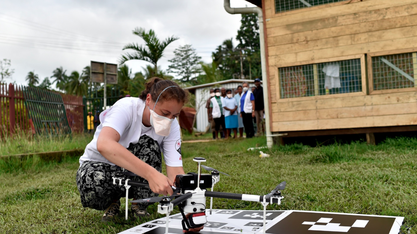
Unpacking and putting together the hexacopters can take a long time. The professional and certified UAV team from New Zealand (X-Craft) follows strict operational check lists to ensure safety and security. We also have a professional and certified team from Australia, Heliwest, which will be flying quadcopters. The UAV team from SPC is also joining our efforts. I’m proud to report that both the Australian & New Zealand teams were recruited directly from the pilot roster of the Humanitarian UAV Network.

WP7

WP8

WP11

WP9

WP10

The payload (camera) attached to our hexacopters; not exactly a GoPro. We also have other sensors for thermal imaging, etc.

WP12

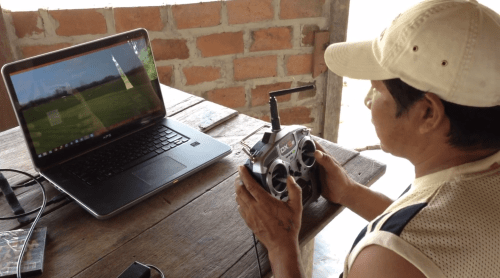
Programming the test flights. Here’s a quick video intro on how to program UAVs for autonomous flights.

WP13

Night falls fast in Vanuatu…

WP14

WP14b

… So our helpful drivers kindly light up our work area.

WP15

After flawless test flights; we’re back at “HQ” to program the flight paths for tomorrow morning’s humanitarian UAV missions. The priority survey areas tend to change on a daily basis as the government gets more information on which outlying islands have been hardest hit. Our first mission will focus on an area comprised of informal settlements.

WP16

WP16b

Dawn starts to break at 0500. We haven’t gotten much sleep.

WP17

At 0600, we arrive at the designated meeting point, the Beach Bar. This will be our base of operations for this morning’s mission.

WP18

WP19

The flight plans for the hexacopters are ready to go. We have clearance from Air Traffic Control (ATC) to fly until 0830 as manned aircraft start operating extensively after 0900. So in complex airspaces like this one in Vanuatu’s Port Vila, we only fly very early in the morning and after 1700 in the evening. We have ATC’s direct phone number and are in touch with the tower at all times.

WP20

Could this be the one and only SXSW 2015 bag in Vanuatu?

WP20b

All our multirotor UAVs have been tested once again and are now ready to go. The government has already communicated to nearby villages that UAVs will be operating between 0630-0830. We aim to collect aerial imagery at a resolution of 4cm-6cm throughout our missions.

WP22

WP21

An old basketball court; perfect for take-off & landing.

WP23

And of course, when we’re finally ready to fly, it starts to pour. Other challenges include an ash cloud from a nearby volcano. We’ve also been told that kids here are pro’s with slingshots (which is one reason why the government informed local villagers of the mission; i.e., to request that kids not use the UAVs for target practice).

WP24

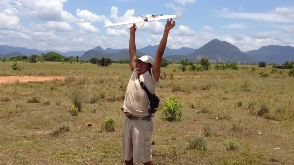
After some delays, we are airborne at last.

WP26

Operating the UAViators DJI Phantom…

WP26b

… Which I’m using purely for documentary purposes. In coming days, we’ll be providing our government partners with a hands-on introduction on how to operate Phantom II’s. Building local capacity is key; which is why this action item is core to the Humanitarian UAV Network’s Code of Conduct.

WP27

WP27b

WP27c

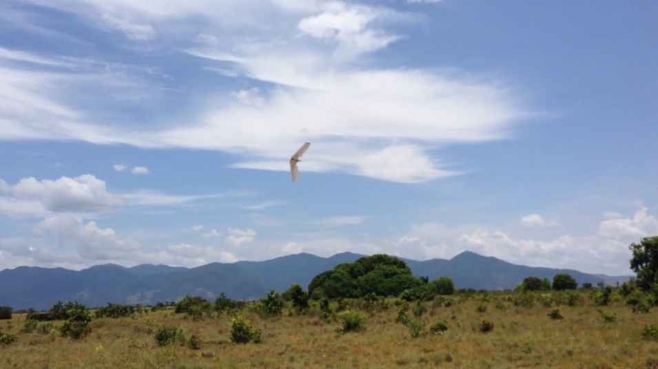
Can you spot the hexacopter? While there’s only one in the picture below, we actually have two in the air at different altitudes which we are operating by Extended Line of Site and First Person View as a backup.

WP27a

More aerial shots I took using the Phantom (not for damage assessment; simply for documentary purposes).

Screen Shot 2015-03-28 at 9.55.11 PM

Can you spot the basketball court?

WP28

Large clouds bring back the rain; visibility is reduced. We have to suspend our flights; will try again after 1700.

WP30

WP31

WP29

Meanwhile, my Phantom’s GoPro snaps this close up picture on landing.

WP32

Stay tuned for updates and in particular the very high resolution aerial imagery that we’ll be posting to MapBox in coming days; along with initial analysis carried out by multiple partners including Humanitarian OpenStreetMap (HOT) and QCRI‘s MicroMappers. Many thanks to MapBox for supporting our efforts. We will also be overlaying the aerial imagery analysis over this MicroMappers crisis map of ground-based pictures of disaster damage in order to triangulate the damage assessment results. Check out the latest update here.

In the meantime, more information on this Humanitarian UAV Mission to Vanuatu–spearheaded by the World Bank in very close collaboration with the Government and SPC–can be found on the Humanitarian UAV Network (UAViators) Ops page here. UAViators is an initiative I launched at QCRI following Typhoon Haiyan in the Philippines in 2013. More on UAViators and the use of humanitarian UAVs in my new book Digital Humanitarians.

Important: this blog post is a personal update written in my personal capacity; none of the above is in any way shape or form a formal communique or press release by any of the partners. Official updates will be provided by the Government of Vanuatu and World Bank directly. Please contact me here for official media requests; kindly note that my responses will need to be cleared by the Government & Bank first.

What to Know When Using Humanitarian UAVs for Transportation

UAVs can support humanitarian action in a variety of ways. Perhaps the most common and well-documented use-case is data collection. There are several other use-cases, however, such as payload transportation, which I have blogged about herehere and here. I had the opportunity to learn more about the logistics and operations of payload UAVs while advising a well-known public health NGO in Liberia as well as an international organization in Tanzania. This advising led to conversations with some of the leading experts in the UAV-for-transportation space like Google Project WingMatternet and Vayu for example.

UAV payload unit

Below are just some of the questions you’ll want to ask when you’re considering the use of UAVs for the transportation of small payloads. Of course, the UAV may not be the most appropriate technology for the problem you’re looking to solve. So naturally, the very first step is to carry out a comparative cost-benefit analysis with multiple technologies. The map below, kindly shared by Matternet, is from a project they’re working on with Médecins Sans Frontières (MSF) in Papua New Guinea.

Credit: Matternet

Why does it take some 4 hours to drive 60km (40 miles) compared to 55 minutes by UAV? The pictures below (also shared by Matternet) speak for themselves.

Credit: Matternet

Credit: Matternet

Credit: Matternet

Any use of UAVs in humanitarian contexts should follow the Code of Conduct proposed by the Humanitarian UAV Network (UAViators), which was recently endorsed by the UN. Some of the (somewhat obvious) questions you’ll want to bear in mind as you carry out your cost-benefit analysis thus include:

  • What is maximum, minimum and the average distance that the UAV needs to fly?
  • How frequently do the UAVs need to make the deliveries?
  • How much mass needs to be moved per given amount of time?
  • What is the mass of individual packages (and can these be split into smaller parcels if need be)?
  • Do the packages contain a mechanism for cold transport or would the UAV need to provide refrigeration (assuming this is needed)?
  • What do the take-off and landing spaces look like? How much area, type of ground, size of trees or other obstacles nearby?
  • What does the typology between the take-off and landing sites look like? Tall trees, mountains, or other obstructions?
  • Regarding batteries, is there easy access to electricity in the areas where the UAVs will be landing?
  • Is there any form of cell phone coverage in the landing areas?
  • What is the overall fixed and variable cost of operating the payload UAVs compared to other solutions?
  • What impact (both positive and negative) will the introduction of the payload UAV have on the local economy?

While the payload weight is relatively small (1kg-2kg) for low-cost UAVs, keep in mind that UAV flights can continue around the clock. As one of my colleagues at the Syria Airlift Project recently noted, “If  one crew could launch a plane every 5 minutes, that would add up to almost 200kg in an eight-hour time period.”

IMG_1893

Naturally, Google and Matternet are not the only group out there developing UAVs for payload transportation. Amazon, DHL and others are prototyping the same technology. In addition, many of the teams I met at the recent Drones for Good Challenge in Dubai demo’ed payload solutions. One of the competition’s top 5 finalists was Drone Life from Spain. They flew their quadcopter (pictured above) fully autonomously. What’s special about this particular prototype is not just it’s range (40-50km with 2-3kg payload) but the fact that it also includes a fridge (for vaccines, organs, etc.,) that can be remotely monitored in real-time to ensure the temperature remains within required parameters.

At some point in your planning process, you’ll want to map the landing and take-off sites. The map below (click to enlarge) is the one we recently produced for the Tanzania UAV project (which is still being explored). Naturally, all these payload UAV flights would be pre-programmed and autonomous. If you’d like to learn more about how one programs such flights, check out my short video here.

Screen Shot 2015-02-11 at 2.06.45 PM

One other point worth keeping in mind is that UAVs need not be independent from existing transportation infrastructure. One team at the recent Drones for Good Challenge in Dubai suggested using public buses as take-off and landing points for UAVs. A university in the US is actually exploring this same use case, extending the reach of delivery trucks by using UAVs.

Of course, there are a host of issues that one needs to consider when operating any kind of UAV for humanitarian purposes. These include regulations, permits, risk assessments and mitigation strategies, fail safe mechanisms, community engagement, data privacy/security, etc. The above is simply meant to highlight some of the basic questions that need to be posed at the outset of the project. Needless to say, the very first question should always be whether the UAV is indeed the most appropriate tool (cost/benefit analysis) for the task at hand. In any case, the above is obviously not an exhaustive list. So I’d very much welcome feedback on what’s missing. Thank you!

How to Counter Rumors and Prevent Violence Using UAVs

The Sentinel Project recently launched their Human Security UAV program in Kenya’s violence-prone Tana Delta to directly support Una Hakika (“Are You Sure”). Hakika is an information service that serves to “counteract malicious misinformation [disinformation] which has been the trigger for recent outbreaks of violence in the region.” While the Tana Delta is one of Kenya’s least developed areas, both “mobile phone and internet usage is still surprisingly high.” At the same time, misinformation has “played a significant role in causing fear, distrust and hatred between communities” because the Tana Delta is perhaps parado-xically also an “information-starved environment in which most people still rely on word-of-mouth to get news about the world around them.”

TanaDeltaPic2

In other words, there are no objective, authoritative sources of information per se, so Una Hakika (“Are You Sure”) seeks to be the first accurate, neutral and reliable source of information. Una Hakika is powered by a dedicated toll-free SMS short code and an engaged, trusted network of volunteer ambassadors. When the team receives a rumor verification request via SMS, they proceed to verify the rumor and report the findings back (via SMS) to the community. This process involves “gathering a lot of information from various different sources and trying to make sense of it […]. That’s where WikiRumours comes in as our purpose-built software for managing the Una Hakika workflow.”

TanaPic1

A year after implementing the project, the Sentinel team carried out a series of focus groups to assess impact The findings are particularly encouraging. In a way, the Sentinel team has formalized and stream-lined the organic verification process I describe here: How To Use Technology To Counter Rumors During Crises: Anecdotes from Kyrgyzstan. So where do UAVs come in?

The Sentinel team recently introduced the use of UAVs to support Una Hakika’s verification efforts and will be expanding the program to include a small fleet of multi-rotor and fixed wing platforms. Before piloting this new technology, the team carried out research to better understand local perceptions around UAVs (also referred to as Unmanned Aerial Systems, UAS):

“Common public opinion concerns in places like Europe and North America relate to the invasion of privacy, misuse by government or law enforcement, a related concern about an overbearing security state, and fears of an aviation disaster. Concerns found among residents of the Tana Delta revolve around practical issues such as whether the UAS-mounted camera would be powerful enough to be useful, how far such systems can operate, whether they are hampered by weather, how quickly a drone can be deployed in an emergency, and who will be in physical possession of the system.”

“For the most part, they [local residents] are genuinely curious, have a plethora of questions about the implementation of UAS in their communities, and are enthusiastic about the many possibilities. This genuine technological optimism makes the Tana Delta a likely site for one of the first programs of its kind. The Sentinel Project is conducting its UAS operations with the policy of ‘progress through caution,’ which seeks to engage communities within the proposed deployment while offering complete transparency and involvement but always emphasizing exposure to (and demonstration of) systems in the field with the people who have the potential to benefit from these initiatives. This approach has been extremely well received & has already resulted in improvements to implementation.”

While Una Hakika’s verification network includes hundreds of volunteer ambassadors, they can’t be everywhere at the same time. As the Sentinel team mentioned during one of our recent conversations, there are some places that simply can’t be reached by foot reliably. In addition, the UAVs can operate both day and night; wandering around at night can be dangerous for Una Hakika’s verification ambassadors. The Sentinel team thus plans to add InfraRed, thermal imaging capabilities to the UAVs. The core of the program will be to use UAVs to set up perimeter security areas around threatened communities. In addition, the program can address other vectors which have led to recent violence: using the UAVs to help find lost (potentially stolen) cattle, track crop health, and monitor contested land use. The team mentioned that the UAVs could also be used to support search and rescue efforts during periods of drought and floods.

Tana3

Lastly, they’ve started discussing the use of UAVs for payload transportation. For example, UAVs could deliver medical supplies to remote villages that have been attacked. After all, the World Health Organization (WHO) is already using UAVs for this purpose. With each of these applications, the Sentinel team clearly emphasizes that the primary users and operators of the UAVs must be the local staff in the region. “We believe that successful technology driven programs must not only act as tools to serve these communities but also allow community members to have direct involvement in their use”.

As the Sentinel team rightly notes, their approach helps to “counteract the paralysis which arises from the unknowns of a new endeavour when studied in a purely academic setting. The Sentinel Project team believes that a cautious but active strategy of real-world deployments will best demonstrate the value of such programs to governments and global citizens.” This very much resonates with me, which is why I am pleased to serve on the organization’s Advisory Board.

Can This Unique Conservation Drone Be Used for Disaster Response?

I had the distinct honor of both keynoting & judging the outstanding Drones for Good Challenge in Dubai last week (see my live reports). Teams from all around the world came to the UAE to compete. Some of the drones that took to the sky were truly remarkable. The winner of the National Prize, for example, was the Wadi Drone built by the NYU Abu Dhabi Team who took home the one million Dirham reward ($273,000). While designed to support important conservation efforts in the region, the novel solution afforded by this innovative drone could also be used to support humanitarian relief efforts.

Screen Shot 2015-02-11 at 8.38.46 AM

The ultralight Wadi Drone can fly for 1.5 hours across some 40km of the Wadi Wurayah National Park, which is the “UAE’s first mountain protected national park. The drone collects data from 120 camera traps that capture images of wild animals at the park” (1). Thanks to Wadi Drone, rangers no longer have to hike through the park (often facing temperatures upwards of 45 degrees Celsius) to manually collect the SD cards from each of the 120 cameras scattered across the area. Instead, the drone simply flies over the cameras and uploads the pictures directly to an onboard memory card. To date, these cameras have enabled park rangers and conservationists to identify more than 800 specifies, such as foxes, wildcats and lynxes.

What if we used the Wadi Drone to collect relevant data from humanitarian base camps in the field during disasters? Connectivity and bandwidth can often be an issue in these situations. Could we use a version of the Wadi Drone to collect data on damage assessments, resulting needs, etc., along with pictures directly from the field? Laptops and/or smartphones could simply be retrofitted to push relevant data to the drone flying overhead, which would then return to HQ where (hopefully) a more solid Wifi or 3G/4G connection is available.

Am I completely off here, or is this something worth exploring? I hope my more seasoned humanitarian colleagues will chime with some of their thoughts. Is there a role for data-carrying drones in the humanitarian space? Keep in mind that drones are not immune to Moore’s Law.

Aerial Imagery Analysis: Combining Crowdsourcing and Artificial Intelligence

MicroMappers combines crowdsourcing and artificial intelligence to make sense of “Big Data” for Social Good. Why artificial intelligence (AI)? Because regular crowdsourcing alone is no match for Big Data. The MicroMappers platform can already be used to crowdsource the search for relevant tweets as well as pictures, videos, text messages, aerial imagery and soon satellite imagery. The next step is therefore to add artificial intelligence to this crowdsourced filtering platform. We have already done this with tweets and SMS. So we’re now turning our attention to aerial and satellite imagery.

Our very first deployment of MicroMappers for aerial imagery analysis was in Africa for this wildlife protection project. We crowdsourced the search for wild animals in partnership with rangers from the Kuzikus Wildlife Reserve based in Namibia. We were very pleased with the results, and so were the rangers. As one of them noted: “I am impressed with the results. There are at times when the crowd found animals that I had missed!” We were also pleased that our efforts caught the attention of CNN. As noted in that CNN report, our plan for this pilot was to use crowdsourcing to find the wildlife and to then combine the results with artificial intelligence to develop a set of algorithms that can automatically find wild animals in the future.

To do this, we partnered with a wonderful team of graduate students at EPFL, the well known polytechnique in Lausanne, Switzerland. While these students were pressed for time due to a number of deadlines, they were nevertheless able to deliver some interesting results. Their applied, computer vision research is particularly useful given our ultimate aim: to create an algorithm that can learn to detect features of interest in aerial and satellite imagery in near real-time (as we’re interested in applying this to disaster response and other time-sensitive events). For now, however, we need to walk before we can run. This means carrying out the tasks of crowdsourcing and artificial intelligence in two (not-yet-integrated) steps.

MM Oryx

As the EPFL students rightly note in their preliminary study, the use of thermal imaging (heat detection) to automatically identify wildlife in the bush is some-what problematic since “the temperature difference between animals and ground is much lower in savannah […].” This explains why the research team used the results of our crowdsourcing efforts instead. More specifically, they focused on automatically detecting the shadows of gazelles and ostriches by using an object based support vector machine (SVM). The whole process is summarized below.

Screen Shot 2015-02-09 at 12.46.38 AM

The above method produces results like the one below (click to enlarge). The circles represents the objects used to train the machine learning classifier. The discerning reader will note that the algorithm has correctly identified all the gazelles save for one instance in which two gazelles were standing close together were identified as one gazelle. But no other objects were mislabeled as a gazelle. In other words, EPFL’s gazelle algorithm is very accurate. “Hence the classifier could be used to reduce the number of objects to assess manually and make the search for gazelles faster.” Ostriches, on the other hand, proved more difficult to automatically detect. But the students are convinced that this could be improved if they had more time.

Screen Shot 2015-02-09 at 12.56.17 AM

In conclusion, more work certainly needs to be done, but I am pleased by these preliminary and encouraging results. In addition, the students at EPFL kindly shared some concrete features that we can implement on the MicroMappers side to improve the crowdsourced results for the purposes of developing automated algorithms in the future. So a big thank you to Briant, Millet and Rey for taking the time to carry out the above research. My team and I at QCRI very much look forward to continuing our collaboration with them and colleagues at EPFL.

In the meantime, more on all this in my new bookDigital Humanitarians: How Big Data is Changing the Face of Humanitarian Response, which has already been endorsed by faculty at Harvard, MIT, Stanford, Oxford, etc; and by experts at the UN, World Bank, Red Cross, Twitter, etc.

Drones for Good Make History in Dubai

 Screen Shot 2015-02-07 at 11.00.13 AM


We’ve just wrapped up an incredible week at the first ever Drones for Good Challenge. Not only was this the first event of its kind in Dubai, it was the first ever such event in the world. I was thus hugely honored to both keynote this outstanding celebration of technologies for good and to also serve on the judging panel for the finalists. Some 800 teams from nearly 60 countries around the world submitted their “Drones for Good” ideas. Only 5 made it to the very final round today. I lived-tweeted the event and curated the  list of tweets below as a summary (all original tweets available here). My head is still spinning from all the possibilities, ideas and the incredible innovators that I had the good fortune to meet in person. I’ll absolutely be following up with a number of them for several Humanitarian UAV projects I am working on. In the meantime, huge thanks to the organizing event team for their very kind invitation and friendship!

Screen Shot 2015-02-07 at 10.30.19 AM

Screen Shot 2015-02-07 at 10.31.10 AM

Screen Shot 2015-02-07 at 10.31.39 AM

Screen Shot 2015-02-07 at 10.31.56 AM

Screen Shot 2015-02-07 at 10.32.13 AM

Screen Shot 2015-02-07 at 10.45.12 AM

Screen Shot 2015-02-07 at 10.32.34 AM

Screen Shot 2015-02-07 at 10.32.45 AM

Screen Shot 2015-02-07 at 10.33.00 AM

Screen Shot 2015-02-07 at 10.33.16 AM

Screen Shot 2015-02-07 at 10.33.36 AM

Screen Shot 2015-02-07 at 10.33.53 AM

Screen Shot 2015-02-07 at 10.34.28 AM

Screen Shot 2015-02-07 at 10.34.43 AM

Screen Shot 2015-02-07 at 10.35.41 AM

Screen Shot 2015-02-07 at 10.35.52 AM

Screen Shot 2015-02-07 at 10.36.05 AM

Screen Shot 2015-02-07 at 10.36.18 AM

Screen Shot 2015-02-07 at 10.36.40 AM

Screen Shot 2015-02-07 at 10.49.07 AM


Screen Shot 2015-02-07 at 11.02.23 AM

I’m excited to explore the above possibility with a number of key individuals who I met and spoke with whilst in Dubai.

Indigenous Community in Guyana Builds Drones for Good

If you find yourself in the middle of the jungle somewhere in South America and come across this indigenous community, then you’re probably in Guyana:

guyana-tessa-soldering-800

Screen Shot 2015-02-05 at 8.31.01 AM

Screen Shot 2015-02-05 at 8.33.02 AM

guyana-flight-simulator-800

Screen Shot 2015-02-05 at 8.25.35 AM

Screen Shot 2015-02-05 at 8.32.34 AM

Screen Shot 2015-02-05 at 10.09.10 AM

I’ve been an avid fan of Digital Democracy since 2008 and even had the honor of serving on their Advisory Board during the early days. So I was thrilled when friends Emily Jacobi and Gregor MacLennan told me they were interested in using drones/UAVs for their projects. Six months later, the pictures above explain my excitement.

When Gregor traveled down to Guyana a few months ago, he didn’t bring a drone; he simply brought a bunch of parts and glue, lots of glue. “We didn’t want to just fly into Guyana and fly a drone over the local villages,” writes Gregor. “Our interest was whether this technology could be something that can be used and controlled by the commumunities themselves, and become a tool of em-powerment for helping them have more of a say in their own future. We wanted the Wapichana to be able to repair it themselves, fly it themselves, and process the images to use for their own means.” Oh, and by the way, Gregor had never built a drone before.

And that’s the beauty of Digital Democracy’s approach: co-learning, co-creation and co-experimentation. Moreover, Emily & Gregor didn’t turn to drones simply because it’s the latest fad. They tried using satellite imagery to document illegal logging and deforestation in Guyana but the resolution of said imagery was limited. So they figured drones might do the trick instead. Could this technology be a “tool for positive change in the hands of indigenous communities?” Could local communities in Guyana use flying robots to create maps and thus monitor illegal logging and deforestation?

Building the drone was truly a community effort. “When the motor mount broke, the team scoured the village for different types of plastic, and fashioned a new mount from an old beer crate. The drone was no longer a foreign, mysterious piece of technology, but something they owned, built, & therefore understood.” And that is what it’s all about. Check out the neat video above to see the team in action and the 3D results below based on the data collected.

So what’s next? The Wapichana UAV Team have demonstrated “that a remote indigenous community with no prior engineering experience can build and fly a complex drone and make a detailed map.” The team has already been discussing the multiple ways they want to use their UAVs: “to monitor deforestation of bush islands over time; creating high-resolution maps of villages to use as a basis for resource-management discussions; and flying over logging camps in the forest to document illegal deforestation.” You can make sure this happens by donating to the cause (like I just did). That way, Gregor can continue the training and get “the whole team comfortable with flying and to streamline the process from mission planning to processing imagery.”


Meanwhile, back in Congo-Brazzaville…

braza1

… another team was learning about Drones for Good.

Drones for Good: Technology, Social Movements and The State

Discussions surrounding use of drones, or UAVs, have typically “centered on their use by governments, often for the purpose of surveillance and warfare.” But as colleague Austin Choi-Fitzpatrick rightly notes in his new study, “[t]his focus on the state’s use obscures the opportunity for civil society actors, including social movements, to make use of these technologies.” Austin thus seeks to high-light civil society uses, “ranging from art to digital disruption.” The latter is what I am particularly interested given my previous writings on the use of non-lethal UAVs for civil resistance and for peacebuilding.

Screen Shot 2015-02-02 at 7.50.33 AM

When I began writing my doctoral dissertation some 7 years ago, scholars and activists were particularly interested in measuring the impact of mobile phones on social movements and civil resistance. Today, civil society is also turning to UAVs as evidenced during the recent protests in Hong Kong, Turkey, Poland, Ukraine and Ferguson. “This innovation represents a technological shift in scale for citizen journalists, human rights advocates, and social movement actors,” writes Austin. “As such, it requires a sophisticated assessment of the ethical issues and policy terrain surrounding its use.”

The most disruptive aspect of today’s small, personal UAVs, “is the fundamental break between the camera and the street level. […] The most memorable photographs of violent conflict, social protest and natural disasters have almost all been taken by a person present on the ground. […] UAVs relocate the boundary between what is public and what is private, because camera-equipped UAVs more the line of sight from the street to the air. This simple shift effectively pushes public space from the sidewalk to the stairwell, courtyard, rooftop, and so forth.” As Austin rightly concludes, “‘Open air’ and ‘free space’ are no longer as ‘open’ or ‘free’ as they once were. They are instead now occupied or vulnerable to occupation.” The use of the words “occupied” and “occupation” here is indeed intentional. Austin also makes another crucial point: UAVs  represent a type of innovation that is a “hallmark of asymmetrical warfare.”

One of my favorite books, Wasp, illustrates this asymmetry perfectly; as does the Syria Air Lift project. The latter seeks to fly swarms of UAVs to deliver aid to civilians caught in conflict zones. Little surprise, then, that the State is clamping down on civil society uses of UAVs. At times, they even shoot the UAVs down, as evidenced when “police in Istanbul shot down a camera-equipped UAV while it was monitoring large anti-government protests […].” Authorities would not be shooting down UAVs if they did not pose some form of (real or imagined) threat. And even when they pose no direct threat, UAVs are clearly annoying enough to react to (like a wasp or annoying mosquito). Annoyance is a key tactic in civil guerrilla warfare and civil resistance.

SAP_ReutersPic

Austin goes on to propose a “broad framework to guide a range of non-state and non-commercial actor uses of drones.” This framework is comprised of the following 6 principles:

1. Subsidiarity: decision-making and problem solving should occur at the lowest and least sophisticated level possible. I take this to mean that decisions surrounding the use of drones should be taken at the local level (implying local ownership) and that drones should “only be used to address situations for which there is not a less sophisticated, invasive, or novel use.”

2. Physical and material security: self-explanatory – “care must be taken so that these devices do not collide with people or with one another.”

3. Do no harm: emphasizes a “rights-based approach as found in the development and humanitarian aid communities. “The principle is one of proportionality, in which the question to be answered is, ‘Are the risks of using UAVs in a given humanitarian setting outweighed by the expected benefits?'”

4. Public interest: also self-explanatory but “especially sensitive to the importance of investigative journalism that holds to account the powerful and well-resourced, despite attempts by established interests to discredit these efforts.” Public interest should also include the interests of the local community.

5. Privacy: straightforward issue but not easily resolved: “creating a [privacy] framework that applies in all circumstances is nearly impossible in an era in which digital privacy appears to be a mirage […].

6. Data protection: of paramount importance. Aerial footage of protests can be used by governments to “create a database of known activists.” As such, “[c]ontext specific protocols must ensure the security of data, thereby protecting against physical or digital theft or corruption.”

Are there other principles that should factor into the “Drones for Good” frame-work? If so, what are they? I’ll also be asking these questions in Dubai this week where I’m speaking at the Drones for Good Festival.

Video: Digital Humanitarians & Next Generation Humanitarian Technology

How do international humanitarian organizations make sense of the “Big Data” generated during major disasters? They turn to Digital Humanitarians who craft and leverage ingenious crowdsourcing solutions with trail-blazing insights from artificial intelligence to make sense of vast volumes of social media, satellite imagery and even UAV/aerial imagery. They also use these “Big Data” solutions to verify user-generated content and counter rumors during disasters. The talk below explains how Digital Humanitarians do this and how their next generation humanitarian technologies work.

Many thanks to TTI/Vanguard for having invited me to speak. Lots more on Digital Humanitarians in my new book of the same title.

bookcover

Videos of my TEDx talks and the talks I’ve given at the White House, PopTech, Where 2.0, National Geographic, etc., are all available here.

Reflections on Digital Humanitarians – The Book

In January 2014, I wrote this blog post announcing my intention to write a book on Digital Humanitarians. Well, it’s done! And launches this week. The book has already been endorsed by scholars at Harvard, MIT, Stanford, Oxford, etc; by practitioners at the United Nations, World Bank, Red Cross, USAID, DfID, etc; and by others including Twitter and National Geographic. These and many more endorsements are available here. Brief summaries of each book chapter are available here; and the short video below provides an excellent overview of the topics covered in the book. Together, these overviews make it clear that this book is directly relevant to many other fields including journalism, human rights, development, activism, business management, computing, ethics, social science, data science, etc. In short, the lessons that digital humanitarians have learned (often the hard way) over the years and the important insights they have gained are directly applicable to fields well beyond the humanitarian space. To this end, Digital Humanitarians is written in a “narrative and conversational style” rather than with dense, technical language.

The story of digital humanitarians is a multifaceted one. Theirs is not just a story about using new technologies to make sense of “Big Data”. For the most part, digital humanitarians are volunteers; volunteers from all walks of life and who occupy every time zone. Many are very tech-savvy and pull all-nighters, but most simply want to make a difference using the few minutes they have with the digital technologies already at their fingertips. Digital humanitarians also include pro-democracy activists who live in countries ruled by tyrants. This story is thus also about hope and humanity; about how technology can extend our humanity during crises. To be sure, if no one cared, if no one felt compelled to help others in need, or to change the status quo, then no one even would bother to use these new, next generation humanitarian technologies in the first place.

I believe this explains why Professor Leysia Palen included the following in her very kind review of my book: “I dare you to read this book and not have both your heart and mind opened.” As I reflected to my editor while in the midst of book writing, an alternative tag line for the title could very well be “How Big Data and Big Hearts are Changing the Face of Humanitarian Response.” It is personally and deeply important to me that the media, would-be volunteers  and others also understand that the digital humanitarians story is not a romanticized story about a few “lone heroes” who accomplish the impossible thanks to their super human technical powers. There are thousands upon thousands of largely anonymous digital volunteers from all around the world who make this story possible. And while we may not know all their names, we certainly do know about their tireless collective action efforts—they mobilize online from all corners of our Blue Planet to support humanitarian efforts. My book explains how these digital volunteers do this, and yes, how you can too.

Digital humanitarians also include a small (but growing) number of forward-thinking professionals from large and well-known humanitarian organizations. After the tragic, nightmarish earthquake that struck Haiti in January 2010, these seasoned and open-minded humanitarians quickly realized that making sense of “Big Data” during future disasters would require new thinking, new risk-taking, new partnerships, and next generation humanitarian technologies. This story thus includes the invaluable contributions of those change-agents and explains how these few individuals are enabling innovation within the large bureaucracies they work in. The story would thus be incomplete without these individuals; without their appetite for risk-taking, their strategic understanding of how to change (and at times circumvent) established systems from the inside to make their organizations still relevant in a hyper-connected world. This may explain why Tarun Sarwal of the International Committee of the Red Cross (ICRC) in Geneva included these words (of warning) in his kind review: “For anyone in the Humanitarian sector — ignore this book at your peril.”

bookcover

Today, this growing, cross-disciplinary community of digital humanitarians are crafting and leveraging ingenious crowdsourcing solutions with trail-blazing insights from advanced computing and artificial intelligence in order to make sense of “Big Data” generated during disasters. In virtually real-time, these new solutions (many still in early prototype stages) enable digital volunteers to make sense of vast volumes of social media, SMS and imagery captured from satellites & UAVs to support relief efforts worldwide.

All of this obviously comes with a great many challenges. I certainly don’t shy away from these in the book (despite my being an eternal optimist : ). As Ethan Zuckerman from MIT very kindly wrote in his review of the book,

“[Patrick] is also a careful scholar who thinks deeply about the limits and potential dangers of data-centric approaches. His book offers both inspiration for those around the world who want to improve our disaster response and a set of fertile challenges to ensure we use data wisely and ethically.”

Digital humanitarians are not perfect, they’re human, they make mistakes, they fail; innovation, after all, takes experimenting, risk-taking and failing. But most importantly, these digital pioneers learn, innovate and over time make fewer mistakes. In sum, this book charts the sudden and spectacular rise of these digital humanitarians and their next generation technologies by sharing their remarkable, real-life stories and the many lessons they have learned and hurdles both cleared & still standing. In essence, this book highlights how their humanity coupled with innovative solutions to “Big Data” is changing humanitarian response forever. Digital Humanitarians will make you think differently about what it means to be humanitarian and will invite you to join the journey online. And that is what it’s ultimately all about—action, responsible & effective action.

Why did I write this book? The main reason may perhaps come as a surprise—one word: hope. In a world seemingly overrun by heart-wrenching headlines and daily reminders from the news and social media about all the ugly and cruel ways that technologies are being used to spy on entire populations, to harass, oppress, target and kill each other, I felt the pressing need to share a different narrative; a narrative about how selfless volunteers from all walks of life, from all ages, nationalities, creeds use digital technologies to help complete strangers on the other side of the planet. I’ve had the privilege of witnessing this digital good-will first hand and repeatedly over the years. This goodwill is what continues to restore my faith in humanity and what gives me hope, even when things are tough and not going well. And so, I wrote Digital Humanitarians first and fore-most to share this hope more widely. We each have agency and we can change the world for the better. I’ve seen this and witnessed the impact first hand. So if readers come away with a renewed sense of hope and agency after reading the book, I will have achieved my main objective.

For updates on events, talks, trainings, webinars, etc, please click here. I’ll be organizing a Google Hangout on March 5th for readers who wish to discuss the book in more depth and/or follow up with any questions or ideas. If you’d like additional information on this and future Hangouts, please click on the previous link. If you wish to join ongoing conversations online, feel free to do so with the FB & Twitter hashtag #DigitalJedis. If you’d like to set up a book talk and/or co-organize a training at your organization, university, school, etc., then do get in touch. If you wish to give a talk on the book yourself, then let me know and I’d be happy to share my slides. And if you come across interesting examples of digital humanitarians in action, then please consider sharing these with other readers and myself by using the #DigitalJedis hashtag and/or by sending me an email so I can include your observation in my monthly newsletter and future blog posts. I also welcome guest blog posts on iRevolutions.

Naturally, this book would never have existed were it for digital humanitarians volunteering their time—day and night—during major disasters across the world. This book would also not have seen the light of day without the thoughtful guidance and support I received from these mentors, colleagues, friends and my family. I am thus deeply and profoundly grateful for their spirit, inspiration and friendship. Onwards!