Tag Archives: MicroMappers

MicroMappers Launched for Pakistan Earthquake Response (Updated)

Update 1: MicroMappers is now public! Anyone can join to help the efforts!
Update 2: Results of MicroMappers Response to Pakistan Earthquake [Link]

MicroMappers was not due to launch until next month but my team and I at QCRI received a time-sensitive request by colleagues at the UN to carry out an early test of the platform given yesterday’s 7.7 magnitude earthquake, which killed well over 300 and injured hundreds more in south-western Pakistan.

pakistan_quake_2013

Shortly after this request, the UN Office for the Coordination of Humanitarian Affairs (OCHA) in Pakistan officially activated the Digital Humanitarian Network (DHN) to rapidly assess the damage and needs resulting from the earthquake. The award-winning Standby Volunteer Task Force (SBTF), a founding member of the DHN. teamed up with QCRI to use MicroMappers in response to the request by OCHA-Pakistan. This exercise, however, is purely for testing purposes only. We made this clear to our UN partners since the results may be far from optimal.

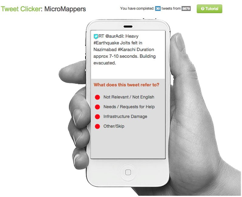
MicroMappers is simply a collection of microtasking apps (we call them Clickers) that we have customized for disaster response purposes. We just launched both the Tweet and Image Clickers to support the earthquake relief and may also launch the Tweet and Image GeoClickers as well in the next 24 hours. The TweetClicker is pictured below (click to enlarge).

MicroMappers_Pakistan1

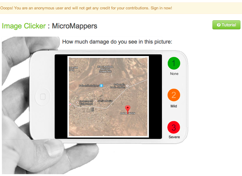
Thanks to our partnership with GNIP, QCRI automatically collected over 35,000 tweets related to Pakistan and the Earthquake (we’re continuing to collect more in real-time). We’ve uploaded these tweets to the TweetClicker and are also filtering links to images for upload to the ImageClicker. Depending on how the initial testing goes, we may be able to invite help from the global digital village. Indeed, “crowdsourcing” is simply another way of saying “It takes a village…” In fact, that’s precisely why MicroMappers was developed, to enable anyone with an Internet connection to become a digital humanitarian volunteer. The Clicker for images is displayed below (click to enlarge).

MicroMappers_Pakistan2

Now, whether this very first test of the Clickers goes well remains to be seen. As mentioned, we weren’t planning to launch until next month. But we’ve already learned heaps from the past few hours alone. For example, while the Clickers are indeed ready and operational, our automatic pre-processing filters are not yet optimized for rapid response. The purpose of these filters is to automatically identify tweets that link to images and videos so that they can be uploaded to the Clickers directly. In addition, while our ImageClicker is operational, our VideoClicker is still under development—as is our TranslateClicker, both of which would have been useful in this response. I’m sure will encounter other issues over the next 24-36 hours. We’re keeping track of these in a shared Google Spreadsheet so we can review them next week and make sure to integrate as much of the feedback as possible before the next disaster strikes.

Incidentally, we (QCRI) also teamed up with the SBTF to test the very first version of the Artificial Intelligence for Disaster Response (AIDR) platform for about six hours. As far as we know, this test represents the first time that machine learning classifiers for disaster resposne were created on the fly using crowdsourcing. We expect to launch AIDR publicly at the 2013 CrisisMappers conference this November (ICCM 2013). We’ll be sure to share what worked and didn’t work during this first AIDR pilot test. So stay tuned for future updates via iRevolution. In the meantime, a big, big thanks to the SBTF Team for rallying so quickly and for agreeing to test the platforms! If you’re interested in becoming a digital humanitarian volunteer, simply join us here.

Bio

MicroMappers: Microtasking for Disaster Response

My team and I at QCRI are about to launch MicroMappers: the first ever set of microtasking apps specifically customized for digital humanitarian response. If you’re new to microtasking in the context of disaster response, then I recommend reading this, this and this. The purpose of our web-based microtasking apps (we call them Clickers) is to quickly make sense of all the user-generated, multi-media content posted on social media during disasters. How? By using microtasking and making it as easy as a single click of the mouse to become a digital humanitarian volunteer. This is how volunteers with Zooniverse were able to click-and-thus-tag well over 2,000,000 images in under 48-hours.

We have already developed and customized four Clickers using the free and open source microtasking platform CrowdCrafting: TweetClicker, TweetGeoClicker, ImageClicker and ImageGeoClicker. Each Clicker includes a mini-tutorial to guide volunteers. While we’re planning to launch them live next month, these Clickers (described below) can be used right now if need be. When a disaster strikes, we can automatically upload tweets to the TweetClicker, for example. These tweets are pre-filtered for keywords and hashtags relevant to the disaster in question. We can also automatically identify multimedia content posted to Twitter and upload this to the ImageClicker to tag pictures that show damage, for example.

TweetClicker

TweetClicker:  This Clicker invites volunteers to tag tweets based on categories specified by an organization like the UN, Red Cross or FEMA. These categories could include those from the UN Cluster System or other information needs.

TweetClicker_screenshot2

ImageClicker

ImageClicker: The purpose of this Clicker is to tag pictures posted on social media (and elsewhere) based on categories specified by a humanitarian organization. Images are auto-matically scraped from Twitter and uploaded to this Clicker.

ImageClicker_screenshot4

TweetGeoClickerTweetGeoClicker: This Clicker invites volunteers to geo-tag tweets (that are not already automatically geo-tagged). The Clicker’s mini-tutorial provides a list of tips on how to find the GPS locations of places mentioned in a given tweet.

TweetGeoClicker_screenshot

ImageGeoClickerImageGeoClicker: The purpose of this Clicker is to geo-tag images posted on social media (that are not geo-tagged auto-matically). Like the Clicker above, a mini-tutorial provides a list of tips on how to find out where a given image was taken.

ImageGeoClicker_screenshot2

We are working on developing several more Clickers such as a VideoClicker and welcome suggestions for other Clickers. We are also developing “Connectors” for the Clickers we’ve developed. That is, once a tweet has been tagged using the TweetClicker, it can be automatically pushed to the TweetGeoClicker for geo-tagging purposes. Note that all our Clickers include built-in quality control mechanisms. For example, only if 3 volunteers tag an image as showing disaster damage does that image get tagged as such. This voting system ensures a high level of data quality.

Finally, we’re developing a Crisis Mapping feature to display geo-tagged tweets and images that are processed using our Clickers. For example, as soon as an image is geo-tagged by 3 volunteers using the ImageGeoClicker, it automatically appears on the live Crisis Map in real-time. Other data visualization features are also possible, such as an interface that provides trends and statistical analysis of the microtasked data. This too is on our to-do list. We’re also looking into making these Clickers useable on smartphones and tablets.

While MicroMappers is a joint collaboration with the United Nations Office for the Coordination of Humanitarian Affairs (OCHA), the Clickers are open for use by other humanitarian organizations such as FEMA and the Red Cross. Simply get in touch with me if you’d like to use these Clickers. In the meantime, many thanks to the Standby Volunteer Task Force (SBTF), a founding member of the Digital Humanitarian Network (DHN), for their invaluable feedback on earlier versions of the Clickers.

Want to be a MicroMapper? Simply join us here! We’ll provide you with updates and let you know when humanitarian organizations need your support to make sense of social media reports following a disaster.

bio

See also: 

  • Results of MicroMappers Response to Pakistan Earthquake (Link)
  • MicroMappers featured on UK Guardian and Wired

TEDx: Microtasking for Disaster Response

My TEDx talk on Digital Humanitarians presented at TEDxTraverseCity. I’ve automatically forwarded the above video to a short 4 minute section of the talk in which I highlight how the Digital Humanitarian Network (DHN) used micro-tasking to support the UN Office for the Coordination of Humanitarian Affairs (OCHA) in response to Typhoon Pablo in the Philippines. See this blog post to learn more about the operation. As a result of this innovative use of micro-tasking, my team and I at QCRI are collaborating with UN OCHA colleagues to launch MicroMappers—a dedicated set of microtasking apps specifically designed for disaster response. These will go live in September 2013.


bio


Introducing MicroMappers for Digital Disaster Response

The UN activated the Digital Humanitarian Network (DHN) on December 3, 2012 to carry out a rapid damage needs assessment in response to Typhoon Pablo in the Philippines. More specifically, the UN requested that Digital Humanitarians collect and geo-reference all tweets with links to pictures or video footage capturing Typhoon damage. To complete this mission, I reached out to my colleagues at CrowdCrafting. Together, we customized a microtasking app to filter, classify and geo-reference thousands of tweets. This type of rapid damage assessment request was the first of its kind, which means that setting up the appropriate workflows and technologies took a while, leaving less time for the tagging, verification and analysis of the multimedia content pointed to in the disaster tweets. Such is the nature of innovation; optimization takes place through iteration and learning.

Microtasking is key to the future of digital humanitarian response, which is precisely why I am launching MicroMappers in partnership with CrowdCrafting. MicroMappers, which combimes the terms Micro-Tasking and Crisis-Mappers, is a collection of free & open source microtasking apps specifically customized and optimized for digital disaster response. The first series of apps focus on rapid damage assessment activations. In other words, the apps include Translate, Locate and Assess. The Translate & Locate Apps are self-explanatory. The Assess App enables digital volunteers to quickly tag disaster tweets that link to relevant multimedia that captures disaster damage. This app also invites volunteers to rate the level of damage in each image and video.

For example, say an earthquake strikes Mexico City. We upload disaster tweets with links to the Translate App. Volunteer translators only translate tweets with location information. These get automatically pushed to the Assess App where digital volunteers tag tweets that point to relevant images/videos. They also rate the level of damage in each. (On a side note, my colleagues and I at QCRI are also developing a crawler that will automatically identify whether links posted on twitter actually point to images/videos). Assessed  tweets are then pushed in real-time to the Locate App for geo-referencing. The resulting tweets are subsequently published to a live map where the underlying data can also be downloaded.  Both the map & data download feature can be password protected.

The plan is to have these apps online and live 24/7 in the event of an activation request. When a request does come in, volunteers with the Digital Humanitarian Network will simply go to MicroMappers.com (not yet live) to start using the apps right away. Members of the public will also be invited to support these efforts and work along side digital humanitarian volunteers. In other words, the purpose of the MicroMappers Apps is not only to facilitate and accelerate digital humanitarian efforts but also to radically democratize these efforts by increasing the participation base. To be sure, one doesn’t need prior training to microtask, simply being able to read and access the web will make you an invaluable member of the team.

We plan to have the MicroMappers Apps completed in May/June September for testing by members of the Digital Humanitarian Network. In the meantime, huge thanks to our awesome partners at CrowdCrafting for making all of this possible! If you’re a coder and interested in contributing to these efforts, please feel free to get in touch with me. We may be able to launch and test these apps earlier with your help. After all, disasters won’t wait until we’re ready and we have several more disaster response apps that are in need of customization.

bio