Category Archives: Crowdsourcing

PeaceTXT Kenya: Since Wars Begin in Minds of Men


“Since wars begin in the minds of men, it is in the minds of men that the defenses of peace must be constructed.” – 
UNESCO Constitution, 1945

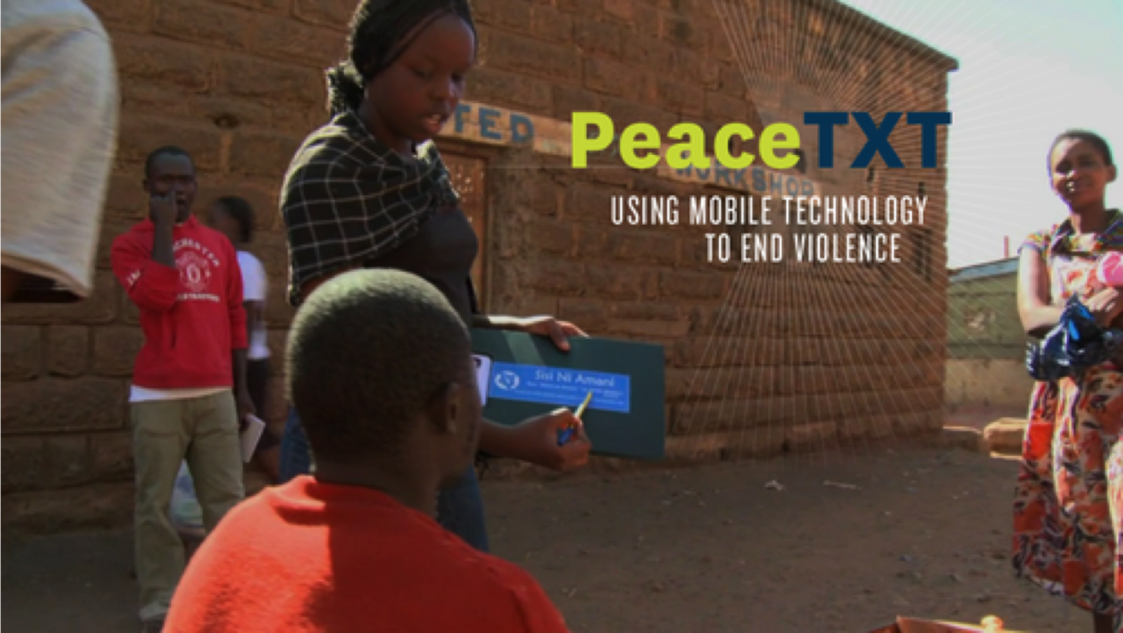
Today, in Kenya, PeaceTXT is building the defenses of peace out of text messages (SMS). As The New York Times explains, PeaceTXT is developing a “text messaging service that sends out blasts of pro-peace messages to specific areas when trouble is brewing.” Launched by PopTech in partnership with the Kenyan NGO Sisi ni Amani (We are Peace), the Kenyan implementation of PeaceTXT uses mobile advertising to market peace and change men’s behaviors.

Conflicts are often grounded in the stories and narratives that people tell them-selves and in the emotions that these stories evoke. Narratives shape identity and the social construct of reality—we interpret our lives through stories. These have the power to transform or infect relationships and communities. As US-based PeaceTXT partner CureViolence (formerly CeaseFire) has clearly shown, violence propagates in much the same way as infectious diseases do. The good news is that we already know how to treat the later: by blocking transmission and treating the infected. This is precisely the approach taken by CureViolence to successfully prevent violence on the streets of Chicago, Baghdad and elsewhere.

The challenge? CureViolence cannot be everywhere at the same time. But the “Crowd” is always there and where the crowd goes, mobile phones often follow. PeaceTXT leverages this new reality by threading a social narrative of peace using mobile messages. Empirical research in public health (and mobile adver-tising) clearly demonstrates that mobile messages & reminders can change behaviors. Given that conflicts are often grounded in the narratives that people tell themselves, we believe that mobile messaging may also influence conflict behavior and possibly prevent the widespread transmission of violent mindsets.

To test this hypothesis, PopTech partnered with Sisi ni Amani in 2011 to pilot and assess the use of mobile messaging for violence interruption and prevention since SNA-K had already been using mobile messaging for almost three years to promote peace, raise awareness about civic rights and encourage recourse to legal instruments for dispute resolution. During the twelve months leading up to today’s Presidential Elections, the Kenyan NGO Sisi ni Amani (SNA-K) has worked with PopTech and PeaceTXT partners (Medic Mobile, QCRI, Ushahidi & CureViolence) to identify the causes of peace in some of the country’s most conflict-prone communities. Since wars begin in the minds of men, SNA-K has held dozens of focus groups in many local communities to better understand the kinds of messaging that might make would-be perpetrators think twice before committing violence. Focus group participants also discussed the kinds of messaging needed to counter rumors. Working with Ogilvy, a global public relations agency with expertise in social marketing, SNA-K subsequently codified the hundreds of messages developed by the local communities to produce a set of guidelines for SNA-K staff to follow. These guidelines describe what types of messages to send to whom, where and when depending on the kinds of tensions being reported.

In addition to organizing these important focus groups, SNA-K literally went door-to-door in Kenya’s most conflict-prone communities to talk with residents about PeaceTXT and invite them to subscribe to SNA-Ks free SMS service. Today, SNA-K boasts over 60,000 SMS subscribers across the country. Thanks to Safaricom, the region’s largest mobile operator, SNA-K will be able to send out 50 million text messages completely for free, which will significantly boost the NGO’s mobile reach during today’s elections. And thanks to SNA-K’s customized mobile messaging platform built by the Praekelt Foundation, the Kenyan NGO can target specific SMS’s to individual subscribers based on their location, gender and demographics. In sum, as CNN explains, “the intervention combines targeted SMS with intensive on-the-ground work by existing peace builders and community leaders to target potential flashpoints of violence.” 

The partnership with Pop-Tech enabled SNA-K to scale thanks to the new funding and strategic partnerships provided by PopTech. Today, PeaceTXT and Sisi ni Amani have already had positive impact in the lead up to today’s important elections. For example, a volatile situation in Dandora recently led to the stabbing of several individuals, which could have resulted in a serious escalation of violence. So SNA-K sent the following SMS: 

Screen Shot 2013-03-03 at 4.34.44 PM 

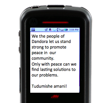
“Tu dumisha amani!” means “Lets keep the peace!” SNA-K’s local coordinator in Dandore spoke with a number of emotionally distraught and (initially) very angry individuals in the area who said they had been ready to mobilizing and take revenge. But, as they later explained, the SMS sent out by SNA-K made them think twice. They discussed the situation and decided that more violence wouldn’t bring their friend back and would only bring more violence. They chose to resolve the volatile situation through mediation instead.

In Sagamian, recent tensions over land issues resulted in an outbreak of violence. So SNA-K sent the following message:

Screen Shot 2013-03-03 at 4.37.48 PM 

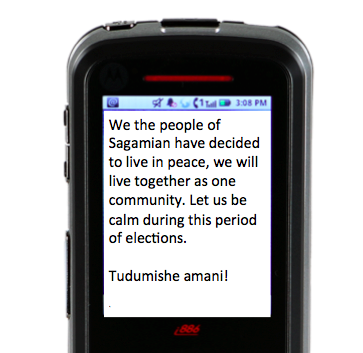
Those involved in the fighting subsequently left the area, telling SNA-K that they had decided not to fight after receiving the SMS. What’s more, they even requested that additional messages to be sent. Sisi ni Amani has collected dozens of such testimonials, which suggest that PeaceTXT is indeed having an impact. Historian Geoffrey Blainey once wrote that “for every thousand pages on the causes of war, there is less than one page directly on the causes of peace.” Today, the PeaceTXT Kenya & SNAK partnership is making sure that for every one SMS that may incite violence, a thousand messages of peace, calm and solidarity will follow to change the minds of men. Tudumishe amani!

bio

Cross-posted on PopTech blog.

Keynote: Next Generation Humanitarian Technology

I’m excited to be giving the Keynote address at the Social Media and Response Management Interface Event (SMARMIE 2013) in New York this morning. A big thank you to the principal driver behind this important event, Chuck Frank, for kindly inviting me to speak. This is my first major keynote since joining QCRI, so I’m thrilled to share what I’ve learned during this time and my vision for the future of humanitarian technology. But I’m even more excited by the selection of speakers and caliber of participants. I’m eager to learn about their latest projects, gain new insights and hopefully create pro-active partnerships moving forward.

You can follow this event via live stream and @smarmieNYC & #smarmie). I  plan to live tweeting the event at @patrickmeier. My slides are available for download here (125MB). Each slide include speaking notes, which may be of interest to folks who are unable to follow via live stream. Feel free to use my slides but strictly for non-commercial purposes and only with direct attribution. I’ll be sure to post the video of my talk on iRevolution when it becomes available. In the meantime, these videos and publications may be of interest. Also, I’ve curated the table of contents below with 60+ links to every project and/or concept referred to in my keynote and slides (in chronological order) so participants and others can revisit these after the conference—and more importantly keep our conver-sations going via Twitter and the comments section of the blog posts. I plan to hire a Research Assistant in the near future to turn these (and other posts) into a series of up-to-date e-books in which I’ll cite and fully credit the most interesting and insightful comments posted on iRevolution.

Social Media Pulse of Planet

http://iRevolution.net/2013/02/02/pulse-of-the-planet
http://iRevolution.net/2013/02/06/the-world-at-night
http://iRevolution.net/2011/04/20/network-witness

Big Crisis Data and Added Value

http://iRevolution.net/2011/06/22/no-data-bad-data

http://iRevolution.net/2012/02/26/mobile-technologies-crisis-mapping-disaster-response

http://iRevolution.net/2012/12/17/debating-tweets-disaster

http://iRevolution.net/2012/07/18/disaster-tweets-for-situational-awareness

http://iRevolution.net/2013/01/11/disaster-resilience-2-0

Standby Task Force (SBTF)

http://blog.standbytaskforce.com

http://iRevolution.net/2010/09/26/crisis-mappers-task-force

Libya Crisis Map

http://blog.standbytaskforce.com/libya-crisis-map-report

http://irevolution.net/2011/03/04/crisis-mapping-libya

http://iRevolution.net/2011/03/08/volunteers-behind-libya-crisis-map

http://iRevolution.net/2011/06/12/im-not-gaddafi-test

Philippines Crisis Map

http://iRevolution.net/2012/12/05/digital-response-to-typhoon-philippines

http://iRevolution.net/2012/12/08/digital-response-typhoon-pablo

http://iRevolution.net/2012/12/06/digital-disaster-response-typhoon

http://iRevolution.net/2012/06/03/geofeedia-for-crisis-mapping

http://iRevolution.net/2013/02/26/crowdflower-for-disaster-response

Digital Humanitarians 

http://www.digitalhumanitarians.com

Human Computation

http://iRevolution.net/2013/01/20/digital-humanitarian-micro-tasking

Human Computation for Disaster Response (submitted for publication)

Syria Crisis Map

http://iRevolution.net/2012/03/25/crisis-mapping-syria

http://iRevolution.net/2012/11/27/usaid-crisis-map-syria

http://iRevolution.net/2012/07/30/collaborative-social-media-analysis

http://iRevolution.net/2012/05/29/state-of-the-art-digital-disease-detection

Hybrid Systems for Disaster Response

http://iRevolution.net/2012/10/21/crowdsourcing-and-advanced-computing

http://iRevolution.net/2012/07/30/twitter-for-humanitarian-cluster

http://iRevolution.net/2013/02/11/update-twitter-dashboard

Credibility of Social Media: Compare to What?

http://iRevolution.net/2013/01/08/disaster-tweets-versus-911-calls

http://iRevolution.net/2010/09/22/911-system

Human Computed Crediblity 

http://iRevolution.net/2012/07/26/truth-and-social-media

http://iRevolution.net/2011/11/29/information-forensics-five-case-studies

http://iRevolution.net/2010/06/30/crowdsourcing-detective

http://iRevolution.net/2012/11/20/verifying-source-credibility

http://iRevolution.net/2012/09/16/accelerating-verification

http://iRevolution.net/2010/09/19/veracity-of-tweets-during-a-major-crisis

http://iRevolution.net/2011/03/26/technology-to-counter-rumors

http://iRevolution.net/2012/03/10/truthiness-as-probability

http://iRevolution.net/2013/01/27/mythbuster-tweets

http://iRevolution.net/2012/10/31/hurricane-sandy

http://iRevolution.net/2012/07/16/crowdsourcing-for-human-rights-monitoring-challenges-and-opportunities-for-information-collection-verification

Verily: Crowdsourced Verification

http://iRevolution.net/2013/02/19/verily-crowdsourcing-evidence

http://iRevolution.net/2011/11/06/time-critical-crowdsourcing

http://iRevolution.net/2012/09/18/six-degrees-verification

http://iRevolution.net/2011/09/26/augmented-reality-crisis-mapping

AI Computed Credibility

http://iRevolution.net/2012/12/03/predicting-credibility

http://iRevolution.net/2012/12/10/ranking-credibility-of-tweets

Future of Humanitarian Tech

http://iRevolution.net/2012/04/17/red-cross-digital-ops

http://iRevolution.net/2012/11/15/live-global-twitter-map

http://iRevolution.net/2013/02/16/crisis-mapping-minority-report

http://iRevolution.net/2012/04/09/humanitarian-future

http://iRevolution.net/2011/08/22/khan-borneo-galaxies

http://iRevolution.net/2010/03/24/games-to-turksource

http://iRevolution.net/2010/07/08/cognitive-surplus

http://iRevolution.net/2010/08/14/crowd-is-always-there

http://iRevolution.net/2011/09/14/crowdsource-crisis-response

http://iRevolution.net/2012/07/04/match-com-for-economic-resilience

http://iRevolution.net/2013/02/27/matchapp-disaster-response-app

http://iRevolution.net/2013/01/07/what-waze-can-teach-us

Policy

http://iRevolution.net/2012/12/04/catch-22

http://iRevolution.net/2012/02/05/iom-data-protection

http://iRevolution.net/2013/01/23/perils-of-crisis-mapping

http://iRevolution.net/2013/02/25/launching-sms-code-of-conduct

http://iRevolution.net/2013/02/26/haiti-lies

http://iRevolution.net/2012/06/04/big-data-philanthropy-for-humanitarian-response

http://iRevolution.net/2012/07/25/become-a-data-donor

Bio

ps. Please let me know if you find any broken links so I can fix them, thank you!

MatchApp: Next Generation Disaster Response App?

Disaster response apps have multiplied in recent years. I’ve been  reviewing the most promising ones and have found that many cater to  professional responders and organizations. While empowering paid professionals is a must, there has been little focus on empowering the real first responders, i.e., the disaster-affected communities themselves. To this end, there is always a dramatic mismatch in demand for responder services versus supply, which is why crises are brutal audits for humanitarian organizations. Take this Red Cross survey, which found that 74% of people who post a need on social media during a disaster expect a response within an hour. But paid responders cannot be everywhere at the same time during a disaster. The response needs to be decentralized and crowdsourced.

Screen Shot 2013-02-27 at 4.08.03 PM

In contrast to paid responders, the crowd is always there. And most survivals following a disaster are thanks to local volunteers and resources, not external aid or relief. This explains why FEMA Administrator Craig Fugate has called on the public to become a member of the team. Decentralization is probably the only way for emergency response organizations to improve their disaster audits. As many seasoned humanitarian colleagues of mine have noted over the years, the majority of needs that materialize during (and after) a disaster do not require the attention of paid disaster responders with an advanced degree in humanitarian relief and 10 years of experience in Haiti. We are not all affected in the same way when disaster strikes, and those less affected are often very motivated and capable at responding to the basic needs of those around them. After all, the real first responders are—and have always been—the local communities themselves, not the Search and Rescue Teams that parachutes in 36 hours later.

In other words, local self-organized action is a natural response to disasters. Facilitated by social capital, self-organized action can accelerate both response & recovery. A resilient community is therefore one with ample capacity for self-organization. To be sure, if a neighborhood can rapidly identify local needs and quickly match these with available resources, they’ll rebound more quickly than those areas with less capacity for self-organized action. The process is a bit like building a large jigsaw puzzle, with some pieces standing for needs and others for resources. Unlike an actual jigsaw puzzle, however, there can be hundreds of thousands of pieces and very limited time to put them together correctly.

This explains why I’ve long been calling for a check-in & match.com smartphone app for local collective disaster response. The talk I gave (above) at Where 2.0 in 2011 highlights this further as do the blog posts below.

Check-In’s with a Purpose: Applications for Disaster Response
http://iRevolution.net/2011/02/16/checkins-for-disaster-response

Maps, Activism & Technology: Check-In’s with a Purpose
http://iRevolution.net/2011/02/05/check-ins-with-a-purpose

Why Geo-Fencing Will Revolutionize Crisis Mapping
http://iRevolution.net/2011/08/21/geo-fencing-crisis-mapping

How to Crowdsource Crisis Response
http://iRevolution.net/2011/09/14/crowdsource-crisis-response

The Crowd is Always There
http://iRevolution.net/2010/08/14/crowd-is-always-there

Why Crowdsourcing and Crowdfeeding may be the Answer
http://iRevolution.net/2010/12/29/crowdsourcing-crowdfeeding

Towards a Match.com for Economic Resilience
http://iRevolution.net/2012/07/04/match-com-for-economic-resilience

This “MatchApp” could rapidly match hyper local needs with resources (material & informational) available locally or regionally. Check-in’s (think Foursquare) can provide an invaluable function during disasters. We’re all familiar with the command “In case of emergency break glass,” but what if: “In case of emergency, then check-in”? Checking-in is space- and time-dependent. By checking in, I announce that I am at a given location at a specific time with a certain need (red button). This means that information relevant to my location, time, user-profile (and even vital statistics) can be customized and automatically pushed to my MatchApp in real-time. After tapping on red, MatchApp prompts the user to select what specific need s/he has. (Yes, the icons I’m using are from the MDGs and just placeholders). Note that the App we’re building is for Androids, not iPhones, so the below is for demonstration purposes only.

Screen Shot 2013-02-27 at 3.32.29 PM

But MatchApp will also enable users who are less (or not) affected by a disaster to check-in and offer help (by tapping the green button). This is where the match-making algorithm comes to play. There are various (compatible options) in this respect. The first, and simplest, is to use a greedy algorithm. This  algorithm select the very first match available (which may not be the most optimal one in terms of location). A more sophisticated approach is to optimize for the best possible match (which is a non-trivial challenge in advanced computing). As I’m a big fan of Means of Exchange, which I have blogged about here, MatchApp would also enable the exchange of goods via bartering–a mobile eBay for mutual-help during disasters.

Screen Shot 2013-02-27 at 3.34.17 PM

Once a match is made, the two individuals in question receive an automated alert notifying them about the match. By default, both users’ identities and exact locations are kept confidential while they initiate contact via the app’s instant messaging (IM) feature. Each user can decide to reveal their identity/location at any time. The IM feature thus enables  users to confirm that the match is indeed correct and/or still current. It is then up to the user requesting help to share her or his location if they feel comfortable doing so. Once the match has been responded to, the user who received help is invited to rate the individual who offered help (and vice versa, just like the Uber app, depicted on the left below).

Screen Shot 2013-02-27 at 3.49.04 PM

As a next generation disaster response app, MatchApp would include a number of additional data entry features. For example, users could upload geo-tagged pictures and video footage (often useful for damage assessments).  In terms of data consumption and user-interface design,  MatchApp would be modeled along the lines of the Waze crowdsourcing app (depicted on the right above) and thus designed to work mostly “hands-free” thanks to a voice-based interface. (It would also automatically sync up with Google Glasses).

In terms of verifying check-in’s and content submitted via MatchApp, I’m a big fan of InformaCam and would thus integrate the latter’s meta-data verification features into MatchApp: “the user’s current GPS coordinates, altitude, compass bearing, light meter readings, the signatures of neighboring devices, cell towers, and wifi networks; and serves to shed light on the exact circumstances and contexts under which the digital image was taken.” I’ve also long been interested in peer-to-peer meshed mobile communication solutions and would thus want to see an integration with the Splinternet app, perhaps. This would do away with the need for using cell phone towers should these be damaged following a disaster. Finally, MatchApp would include an agile dispatch-and-coordination feature to allow “Super Users” to connect and coordinate multiple volunteers at one time in response to one or more needs.

In conclusion, privacy and security are a central issue for all smartphone apps that share the features described above. This explains why reviewing the security solutions implemented by multiple dating websites (especially those dating services with a strong mobile component like the actual Match.com app) is paramount. In addition, reviewing  security measures taken by Couchsurfing, AirBnB and online classified adds such as Craig’s List is a must. There is also an important role for policy to play here: users who submit false misinformation to MatchApp could be held accountable and prosecuted. Finally, MatchApp would be free and open source, with a hyper-customizable, drag-and-drop front- and back-end.

bio

Using CrowdFlower to Microtask Disaster Response

Cross-posted from CrowdFlower blog

A devastating earthquake struck Port-au-Prince on January 12, 2010. Two weeks later, on January 27th, a CrowdFlower was used to translate text messages from Haitian Creole to English. Tens of thousands of messages were sent by affected Haitians over the course of several months. All of these were heroically translated by hundreds of dedicated Creole-speaking volunteers based in dozens of countries across the globe. While Ushahidi took the lead by developing the initial translation platform used just days after the earthquake, the translation efforts were eventually rerouted to CrowdFlower. Why? Three simple reasons:

  1. CrowdFlower is one of the leading and most highly robust micro-tasking platforms there is;
  2. CrowdFlower’s leadership is highly committed to supporting digital humanitarian response efforts;
  3. Haitians in Haiti could now be paid for their translation work.

While the CrowdFlower project was launched 15 days after the earthquake, i.e., following the completion of search and rescue operations, every single digital humanitarian effort in Haiti was reactive. The key takeaway here was the proof of concept–namely that large-scale micro-tasking could play an important role in humanitarian information management. This was confirmed months later when devastating floods inundated much of Pakistan. CrowdFlower was once again used to translate incoming messages from the disaster affected population. While still reactive, this second use of CrowdFlower demonstrated replicability.

The most recent and perhaps most powerful use of CrowdFlower for disaster response occurred right after Typhoon Pablo devastated the Philippines in early December 2012. The UN Office for the Coordination of Humanitarian Affairs (OCHA) activated the Digital Humanitarian Network (DHN) to rapidly deliver a detailed dataset of geo-tagged pictures and video footage (posted on Twitter) depicting the damage caused by the Typhoon. The UN needed this dataset within 12 hours, which required that 20,000 tweets to be analyzed as quickly as possible. The Standby Volunteer Task Force (SBTF), a member of Digital Huma-nitarians, immediately used CrowdFlower to identify all tweets with links to pictures & video footage. SBTF volunteers subsequently analyzed those pictures and videos for damage and geographic information using other means.

This was the most rapid use of CrowdFlower following a disaster. In fact, this use of CrowdFlower was pioneering in many respects. This was the first time that a member of the Digital Humanitarian Network made use of CrowdFlower (and thus micro-tasking) for disaster response. It was also the first time that Crowd-Flower’s existing workforce was used for disaster response. In addition, this was the first time that data processed by CrowdFlower contributed to an official crisis map produced by the UN for disaster response (see above).

These three use-cases, Haiti, Pakistan and the Philippines, clearly demonstrate the added value of micro-tasking (and hence CrowdFlower) for disaster response. If CrowdFlower had not been available in Haiti, the alternative would have been to pay a handful of professional translators. The total price could have come to some $10,000 for 50,000 text messages (at 0.20 cents per word). Thanks to CrowdFlower, Haitians in Haiti were given the chance to make some of that money by translating the text messages themselves. Income generation programs are absolutely critical to rapid recovery following major disasters. In Pakistan, the use of CrowdFlower enabled Pakistani students and the Diaspora to volunteer their time and thus accelerate the translation work for free. Following Typhoon Pablo, paid CrowdFlower workers from the Philippines, India and Australia categorized several thousand tweets in just a couple hours while the volunteers from the Standby Volunteer Task Force geo-tagged the results. Had CrowdFlower not been available then, it is highly, highly unlikely that the mission would have succeeded given the very short turn-around required by the UN.

While impressive, the above use-cases were also reactive. We need to be a lot more pro-active, which is why I’m excited to be collaborating with CrowdFlower colleagues to customize a standby platform for use by the Digital Humanitarian Network. Having a platform ready-to-go within minutes is key. And while digital volunteers will be able to use this standby platform, I strongly believe that paid CrowdFlower workers also have a key role to play in the digital huma-nitarian ecosystem. Indeed, CrowdFlower’s large, multinational and multi-lingual global workforce is simply unparalleled and has the distinct advantage of being very well versed in the CrowdFlower platform.

In sum, it is high time that the digital humanitarian space move from crowd-sourcing to micro-tasking. It has been three years since the tragic earthquake in Haiti but we have yet to adopt micro-tasking more widely. CrowdFlower should thus play a key role in promoting and enabling this important shift. Their con-tinued important leadership in digital humanitarian response should also serve as a model for other private sector companies in the US and across the globe.

bio

Launching: SMS Code of Conduct for Disaster Response

Shortly after the devastating Haiti Earthquake of January 12, 2010, I published this blog post on the urgent need for an SMS code of conduct for disaster response. Several months later, I co-authored this peer-reviewed study on the lessons learned from the unprecedented use of SMS following the Haiti Earth-quake. This week, at the Mobile World Congress (MWC 2013) in Barcelona, GSMA’s Disaster Response Program organized two panels on mobile technology for disaster response and used the event to launch an official SMS Code of Conduct for Disaster Response (PDF). GSMA members comprise nearly 800 mobile operators based in more than 220 countries.

Screen Shot 2013-02-18 at 2.27.32 PM

Thanks to Kyla Reid, Director for Disaster Response at GSMA, and to Souktel’s Jakob Korenblummy calls for an SMS code of conduct were not ignored. The three of us spent a considerable amount of time in 2012 drafting and re-drafting a detailed set of principles to guide SMS use in disaster response. During this process, we benefited enormously from many experts on the mobile operators side and the humanitarian community; many of whom are at MWC 2013 for the launch of the guidelines. It is important to note that there have been a number of parallel efforts that our combined work has greatly benefited from. The Code of Conduct we launched this week does not seek to duplicate these important efforts but rather serves to inform GSMA members about the growing importance of SMS use for disaster response. We hope this will help catalyze a closer relationship between the world’s leading mobile operators and the international humanitarian community.

Since the impetus for this week’s launch began in response to the Haiti Earth-quake, I was invited to reflect on the crisis mapping efforts I spearheaded at the time. (My slides for the second panel organized by GSMA are available here. My more personal reflections on the 3rd year anniversary of the earthquake are posted here). For several weeks, digital volunteers updated the Ushahidi-Haiti Crisis Map (pictured above) with new information gathered from hundreds of different sources. One of these information channels was SMS. My colleague Josh Nesbit secured an SMS short code for Haiti thanks to a tweet he posted at 1:38pm on Jan 13th (top left in image below). Several days later, the short code (4636) was integrated with the Ushahidi-Haiti Map.

Screen Shot 2013-02-18 at 2.40.09 PM

We received about 10,000 text messages from the disaster-affected population during the during the Search and Rescue phase. But we only mapped about 10% of these because we prioritized the most urgent and actionable messages. While mapping these messages, however, we had to address a critical issue: data privacy and protection. There’s an important trade-off here: the more open the data, the more widely useable that information is likely to be for professional disaster responders, local communities and the Diaspora—but goodbye privacy.

Time was not a luxury we had; an an entire week had already passed since the earthquake. We were at the tail end of the search and rescue phase, which meant that literally every hour counted for potential survivors still trapped under the rubble. So we immediately reached out to 2 trusted lawyers in Boston, one of them a highly reputable Law Professor at The Fletcher School of Law and Diplomacy who also a specialist on Haiti. You can read the lawyers’ written email replies along with the day/time they were received on the right-hand side of the slide. Both lawyers opined that consent was implied vis-à-vis the publishing of personal identifying information. We shared this opinion with all team members and partners working with us. We then made a joint decision 24 hours later to move ahead and publish the full content of incoming messages. This decision was supported by an Advisory Board I put together comprised of humanitarian colleagues from the Harvard Humanitarian Initiative who agreed that the risks of making this info public were minimal vis-à-vis the principle of Do No HarmUshahidi thus launched a micro-tasking platform to crowdsource the translation efforts and hosted this on 4636.Ushahidi.com [link no longer live], which volunteers from the Diaspora used to translate the text messages.

I was able to secure a small amount of funding in March 2010 to commission a fully independent evaluation of our combined efforts. The project was evaluated a year later by seasoned experts from Tulane University. The results were mixed. While the US Marine Corps publicly claimed to have saved hundreds of lives thanks to the map, it was very hard for the evaluators to corroborate this infor-mation during their short field visit to Port-au-Prince more than 12 months after the earthquake. Still, this evaluation remains the only professional, independent and rigorous assessment of Ushahidi and 4636 to date.

Screen Shot 2013-02-25 at 2.10.47 AM

The use of mobile technology for disaster response will continue to increase for years to come. Mobile operators and humanitarian organizations must therefore be pro-active in managing this increase demand by ensuring that the technology is used wisely. I, for one, never again want to spend 24+ precious hours debating whether or not urgent life-and-death text messages can or cannot be mapped because of uncertainties over data privacy and protection—24 hours during a Search and Rescue phase is almost certain to make the difference between life and death. More importantly, however, I am stunned that a bunch of volunteers with little experience in crisis response and no affiliation whatsoever to any established humanitarian organization were able to secure and use an official SMS short code within days of a major disaster. It is little surprise that we made mistakes. So a big thank you to Kyla and Jakob for their leadership and perseverance in drafting and launching GSMA’s official SMS Code of Conduct to make sure the same mistakes are not made again.

While the document we’ve compiled does not solve every possible challenge con-ceivable, we hope it is seen as a first step towards a more informed and responsible use of SMS for disaster response. Rest assured that these guidelines are by no means written in stone. Please, if you have any feedback, kindly share them in the comments section below or privately via email. We are absolutely committed to making this a living document that can be updated.

To connect this effort with the work that my CrisisComputing Team and I are doing at QCRI, our contact at Digicel during the Haiti response had given us the option of sending out a mass SMS broadcast to their 2 million subscribers to get the word out about 4636. (We had thus far used local community radio stations). But given that we were processing incoming SMS’s manually, there was no way we’d be able to handle the increased volume and velocity of incoming text messages following the SMS blast. So my team and I are exploring the use of advanced computing solutions to automatically parse and triage large volumes of text messages posted during disasters. The project, which currently uses Twitter, is described here in more detail.

bio

Social Media as Passive Polling: Prospects for Development & Disaster Response

My Harvard/MIT colleague Todd Mostak wrote his award-winning Master’s Thesis on “Social Media as Passive Polling: Using Twitter and Online Forums to Map Islamism in Egypt.” For this research, Todd evaluated the “potential of Twitter as a source of time-stamped, geocoded public opinion data in the context of the recent popular uprisings in the Middle East.” More specifically, “he explored three ways of measuring a Twitter user’s degree of political Islamism.” Why? Because he wanted to test the long-standing debate on whether Islamism is associated with poverty.

Screen Shot 2013-02-18 at 11.17.09 AM

So Todd collected millions of geo-tagged tweets from Egypt over a six month period, which he then aggregated by census district in order to regress proxies for poverty against measures of Islamism drived from the tweets and the users’ social graphs. His findings reveal that “Islamist sentiment seems to be positively correlated with male unemployment, illiteracy, and percentage of land used in agriculture and negatively correlated with percentage of men in their youth aged 15-25. Note that female variables for unemployment and age were statistically insignificant.” As with all research, there are caveats such as the weighting scale used for the variables and questions over the reliability of census variables.

Screen Shot 2013-02-18 at 11.15.59 AM

To carry out his graduate research, Todd built a web-enabled database (MapD) powered by a Graphics Processing Units (GPU) to perform real-time querying and visualization of big datasets. He is now working with Harvard’s Center for Geographic Analysis (CGA) to put make this available via a public web interface called Tweetmap. This Big Data streaming and exploration tool presen-tly displays 119 million tweets from 12/10/2012 to 12/31/2012. He is adding 6-7 million new georeferenced tweets per day (but these are not yet publicly available on Tweetmap). According to Todd, the time delay from live tweet to display on the map is about 1 second. Thanks to this GPU-powered approach, he expects that billions of tweets could be displayed in real-time.

Screen Shot 2013-02-18 at 11.14.02 AM

As always with impressive projects, no one single person was behind the entire effort. Ben Lewis, who heads the WorldMap initiative at CGA deserves a lot of credit for making Tweetmap a reality. Indeed, Todd collaborated directly with CGA’s Ben Lewis throughout this project and benefited extensively from his expertise. Matt Bertrand (lead developer for CGA) did the WorldMap-side integration of MapD to create the TweetMap interface.

Todd and I recently spoke about integrating his outstanding work on automated live mapping to QCRI’s Twitter Dashboard for Disaster Response. Exciting times. In the meantime, Todd has kindly shared his dataset of 700+ million geotagged tweets for my team and I to analyze. The reason I’m excited about this approach is best explained with this heatmap of the recent snow-storm in the northeastern US. Todd is already using Tweetmap for live crisis mapping. While this system filters by keyword, our Dashboard will use machine learning to provide more specific streams of relevant tweets, some of which could be automatically mapped on Tweetmap. See Todd’s Flickr page for more Tweetmap visuals.

Screen Shot 2013-02-18 at 11.30.54 AM

I’m also excited by Todd’s GPU-powered approach for a project I’m exploring with UN and World Bank colleagues. The purpose of that research project is to determine whether socio-economic trends such as poverty and unemployment can be captured via Twitter. Our first case study is Egypt. Depending on the results, we may be able to take it one step further by applying sentiment analysis to real-time, georeferenced tweets to visualize Twitter users’ per-ception vis-a-vis government services—a point of interest for my UN colleagues in Cairo.

bio

Verily: Crowdsourced Verification for Disaster Response

Social media is increasingly used for communicating during crises. This rise in Big (Crisis) Data means that finding the proverbial needle in the growing haystack of information is becoming a major challenge. Social media use during Hurricane Sandy produced a “haystack” of half-a-million Instagram photos and 20 million tweets. But which of these were actually relevant for disaster response and could they have been detected in near real-time? The purpose of QCRI’s experimental Twitter Dashboard for Disaster Response project is to answer this question. But what about the credibility of the needles in the info-stack?

10-Red-Balloons

To answer this question, our Crisis Computing Team at QCRI has partnered with the Social Computing & Artificial Intelligence Lab at the Masdar Institute of Science and Technology. This applied research project began with a series of conversations in mid-2012 about DARPA’s Red Balloon Challenge. This challenge posted in 2009 offered $40K to the individual or team that could find the correct location of 10 red weather balloons discretely placed across the continental United States, an area covering well over 3 million square miles (8 million square kilometers). My friend Riley Crane at MIT spearheaded the team that won the challenge in 8 hours and 52 minutes by using social media.

Riley and I connected right after the Haiti Earthquake to start exploring how we might apply his team’s winning strategy to disaster response. But we were pulled in different directions due to PhD & post-doc obligations and start-up’s. Thank-fully, however, Riley’s colleague Iyad Rahwan got in touch with me to continue these conversations when I joined QCRI. Iyad is now at the Masdar Institute. We’re collaborating with him and his students to apply collective intelligence insights from the balloon to address the problem of false or misleading content shared on social media during  disasters.

Screen Shot 2013-02-16 at 2.26.41 AM

If 10 balloons planted across 3 million square miles can be found in under 9 hours, then surely the answer to the question “Did Hurricane Sandy really flood this McDonald’s in Virginia?” can be found in under 9 minutes given that  Virginia is 98% smaller than the “haystack” of the continental US. Moreover, the location of the restaurant would already be known or easily findable. The picture below, which made the rounds on social media during the hurricane is in reality part of an art exhibition produced in 2009. One remarkable aspect of the social media response to Hurricane Sandy was how quickly false information got debunked and exposed as false—not only by one good (digital) Samaritan, but by several.

SandyFake

Having access to accurate information during a crisis leads to more targeted self-organized efforts at the grassroots level. Accurate information is also important for emergency response professionals. The verification efforts during Sandy were invaluable but disjointed and confined to the efforts of a select few individuals. What if thousands could be connected and mobilized to cross-reference and verify suspicious content shared on social media during a disaster?

Say an earthquake struck Santiago, Chile a few minutes ago and contradictory reports begin to circulate on social media that the bridge below may have been destroyed. Determining whether transportation infrastructure is still useable has important consequences for managing the logistics of a disaster response opera-tion. So what if instead of crowdsourcing the correct location of  balloons across an entire country, one could crowdsource the collection of evidence in just one city struck by a disaster to determine whether said bridge had actually been destroyed in a matter of minutes?

santiagobridge

To answer these questions, QCRI and Masdar have launched an experimental  platform called Verily. We are applying best practices in time-critical crowd-sourcing coupled with gamification and reputation mechanisms to leverage the good will of (hopefully) thousands of digital Samaritans during disasters. This is experimental research, which means it may very well not succeed as envisioned. But that is a luxury we have at QCRI—to innovate next-generation humanitarian technologies via targeted iteration and experimentation. For more on this project, our concept paper is available as a Google Doc here. We invite feedback and welcome collaborators.

In the meantime, we are exploring the possibility of integrating the InformCam mobile application as part of Verily. InformaCam adds important metadata to images and videos taken by eyewitnesses. “The metadata includes information like the user’s current GPS coordinates, altitude, compass bearing, light meter readings, the signatures of neighboring devices, cell towers, and wifi net-works; and serves to shed light on the exact circumstances and contexts under which the digital image was taken.” We are also talking to our partners at MIT’s Computer Science & Artificial Intelligence Lab in Boston about other mobile solutions that may facilitate the use of Verily.

Again, this is purely experimental and applied research at this point. We hope to have an update on our progress in the coming months.

Bio

See also:

  •  Crowdsourcing Critical Thinking to Verify Social Media During Crises [Link]
  •  Using Crowdsourcing to Counter Rumors on Social Media [Link]

Video: Minority Report Meets Crisis Mapping

This short video was inspired by the pioneering work of the Standby Volunteer Task Force (SBTF). A global network of 1,000+ digital humanitarians in 80+ countries, the SBTF is responsible for some of the most important live crisis mapping operations that have supported both humanitarian and human rights organizations over the past 2+ years. Today, the SBTF is a founding and active member of the Digital Humanitarian Network (DHN) and remains committed to rapid learning and innovation thanks to an outstanding team of volunteers (“Mapsters”) and their novel use of next-generation humanitarian technologies.

The video first aired on the National Geographic Television Channel in February 2013. A big thanks to the awesome folks from National Geographic and the outstanding Evolve Digital Cinema Team for visioning the future of digital humanitarian technologies—a future that my Crisis Computing Team and I at QCRI are working to create.

An aside: I tried on several occasions to hack the script and say “We” rather than “I” since crisis mapping is very rarely a solo effort but the main sponsor insisted that the focus be on one individual. On the upside, one of the scenes in the commercial is of a Situation Room full of Mapsters coupled with the narration: “Our team can map the pulse of the planet, from anywhere, getting aid to the right places.” Our team = SBTF! Which is why the $$ received for being in this commercial will go towards supporting Mapsters.

bio

Did Terrorists Use Twitter to Increase Situational Awareness?

Those who are still skeptical about the value of Twitter for real-time situational awareness during a crisis ought to ask why terrorists likely think otherwise. In 2008, terrorists carried out multiple attacks on Mumbai in what many refer to as the worst terrorist incident in Indian history. This study, summarized below, explains how the terrorists in question could have used social media for coor-dination and decision-making purposes.

The study argues that “the situational information which was broadcast through live media and Twitter contributed to the terrorists’ decision making process and, as a result, it enhanced the effectiveness of hand-held weapons to accomplish their terrorist goal.” To be sure, the “sharing of real time situational information on the move can enable the ‘sophisticated usage of the most primitive weapons.'” In sum, “unregulated real time Twitter postings can contribute to increase the level of situation awareness for terrorist groups to make their attack decision.”

According to the study, “an analysis of satellite phone conversations between terrorist commandos in Mumbai and remote handlers in Pakistan shows that the remote handlers in Pakistan were monitoring the situation in Mumbai through live media, and delivered specific and situational attack commands through satellite phones to field terrorists in Mumbai.” These conversations provide “evidence that the Mumbai terrorist groups understood the value of up-to-date situation information during the terrorist operation. […] They under-stood that the loss of information superiority can compromise their operational goal.”

Handler: See, the media is saying that you guys are now in room no. 360 or 361. How did they come to know the room you guys are in?…Is there a camera installed there? Switch off all the lights…If you spot a camera, fire on it…see, they should not know at any cost how many of you are in the hotel, what condition you are in, where you are, things like that… these will compromise your security and also our operation […]

Terrorist: I don’t know how it happened…I can’t see a camera anywhere.

A subsequent phone conversation reveals that “the terrorists group used the web search engine to increase their decision making quality by employing the search engine as a complement to live TV which does not provide detailed information of specific hostages. For instance, to make a decision if they need to kill a hostage who was residing in the Taj hotel, a field attacker reported the identity of a hostage to the remote controller, and a remote controller used a search engine to obtain the detailed information about him.”

Terrorist: He is saying his full name is K.R.Ramamoorthy.

Handler: K.R. Ramamoorthy. Who is he? … A designer … A professor … Yes, yes, I got it …[The caller was doing an internet search on the name, and a results showed up a picture of Ramamoorthy] … Okay, is he wearing glasses? [The caller wanted to match the image on his computer with the man before the terrorists.]

Terrorist: He is not wearing glasses. Hey, … where are your glasses?

Handler: … Is he bald from the front?

Terrorist: Yes, he is bald from the front …

The terrorist group had three specific political agendas: “(1) an anti-India agenda, (2) an anti-Israel and anti-Jewish agenda, and (3) an anti-US and anti-Nato agenda.” A content analysis of 900+ tweets posted during the attacks reveal whether said tweets may have provided situational awareness information in support of these three political goals. The results: 18% of tweets contained “situa-tional information which can be helpful for Mumbai terrorist groups to make an operational decision of achieving their Anti-India political agenda. Also, 11.34% and 4.6% of posts contained operationally sensitive information which may help terrorist groups to make an operational decision of achieving their political goals of Anti-Israel/Anti-Jewish and Anti-US/Anti-Nato respectively.”

In addition, the content analysis found that “Twitter site played a significant role in relaying situational information to the mainstream media, which was monitored by Mumbai terrorists. Therefore, we conclude that the Mumbai Twitter page in-directly contributed to enhancing the situational awareness level of Mumbai terrorists, although we cannot exclude the possibility of its direct contribution as well.”

In conclusion, the study stresses the importance analyzing a terrorist group’s political goals in order to develop an appropriate information control strategy. “Because terrorists’ political goals function as interpretative filters to process situational information, understanding of adversaries’ political goals may reduce costs for security operation teams to monitor and decide which tweets need to be controlled.”

bio

See also: Analyzing Tweets Posted During Mumbai Terrorist Attacks [Link]

Update: Twitter Dashboard for Disaster Response

Project name: Artificial Intelligence for Disaster Response (AIDR). For a more recent update, please click here.

My Crisis Computing Team and I at QCRI have been working hard on the Twitter Dashboard for Disaster Response. We first announced the project on iRevolution last year. The experimental research we’ve carried out since has been particularly insightful vis-a-vis the opportunities and challenges of building such a Dashboard. We’re now using the findings from our empirical research to inform the next phase of the project—namely building the prototype for our humanitarian colleagues to experiment with so we can iterate and improve the platform as we move forward.

KnightDash

Manually processing disaster tweets is becoming increasingly difficult and unrealistic. Over 20 million tweets were posted during Hurricane Sandy, for example. This is the main problem that our Twitter Dashboard aims to solve. There are two ways to manage this challenge of Big (Crisis) Data: Advanced Computing and Human Computation. The former entails the use of machine learning algorithms to automatically tag tweets while the latter involves the use of microtasking, which I often refer to as Smart Crowdsourcing. Our Twitter Dashboard seeks to combine the best of both methodologies.

On the Advanced Computing side, we’ve developed a number of classifiers that automatically identify tweets that:

  • Contain informative content (in contrast to personal messages or information unhelpful for disaster response);
  • Are posted by eye-witnesses (as opposed to 2nd-hand reporting);
  • Include pictures, video footage, mentions from TV/radio
  • Report casualties and infrastructure damage;
  • Relate to people missing, seen and/or found;
  • Communicate caution and advice;
  • Call for help and important needs;
  • Offer help and support.

These classifiers are developed using state-of-the-art machine learning tech-niques. This simply means that we take a Twitter dataset of a disaster, say Hurricane Sandy, and develop clear definitions for “Informative Content,” “Eye-witness accounts,” etc. We use this classification system to tag a random sample of tweets from the dataset (usually 100+ tweets). We then “teach” algorithms to find these different topics in the rest of the dataset. We tweak said algorithms to make them as accurate as possible; much like training a dog new tricks like go-fetch (wink).

fetchball

We’ve found from this research that the classifiers are quite accurate but sensitive to the type of disaster being analyzed and also the country in which said disaster occurs. For example, a set of classifiers developed from tweets posted during Hurricane Sandy tend to be less accurate when applied to tweets posted for New Zealand’s earthquake. Each classifier is developed based on tweets posted during a specific disaster. In other words, while the classifiers can be highly accurate (i.e., tweets are correctly tagged as being damage-related, for example), they only tend to be accurate for the type of disaster they’ve been trained for, e.g., weather-related disasters (tornadoes), earth-related (earth-quakes) and water-related (floods).

So we’ve been busy trying to collect as many Twitter datasets of different disasters as possible, which has been particularly challenging and seriously time-consuming given Twitter’s highly restrictive Terms of Service, which prevents the direct sharing of Twitter datasets—even for humanitarian purposes. This means we’ve had to spend a considerable amount of time re-creating Twitter datasets for past disasters; datasets that other research groups and academics have already crawled and collected. Thank you, Twitter. Clearly, we can’t collect every single tweet for every disaster that has occurred over the past five years or we’ll never get to actually developing the Dashboard.

That said, some of the most interesting Twitter disaster datasets are of recent (and indeed future) disasters. Truth be told, tweets were still largely US-centric before 2010. But the international coverage has since increased, along with the number of new Twitter users, which almost doubled in 2012 alone (more neat stats here). This in part explains why more and more Twitter users actively tweet during disasters. There is also a demonstration effect. That is, the international media coverage of social media use during Hurricane Sandy, for example, is likely to prompt citizens in other countries to replicate this kind of pro-active social media use when disaster knocks on their doors.

So where does this leave us vis-a-vis the Twitter Dashboard for Disaster Response? Simply that a hybrid approach is necessary (see TEDx talk above). That is, the Dashboard we’re developing will have a number of pre-developed classifiers based on as many datasets as we can get our hands on (categorized by disaster type). In addition to that, the dashboard will also allow users to create their own classifiers on the fly by leveraging human computation. They’ll also be able to microtask the creation of new classifiers.

In other words, what they’ll do is this:

  • Enter a search query on the dashboard, e.g., #Sandy.
  • Click on “Create Classifier” for #Sandy.
  • Create a label for the new classifier, e.g., “Animal Rescue”.
  • Tag 50+ #Sandy tweets that convey content about animal rescue.
  • Click “Run Animal Rescue Classifier” on new incoming tweets.

The new classifier will then automatically tag incoming tweets. Of course, the classifier won’t get it completely right. But the beauty here is that the user can “teach” the classifier not to make the same mistakes, which means the classifier continues to learn and improve over time. On the geo-location side of things, it is indeed true that only ~3% of all tweets are geotagged by users. But this figure can be boosted to 30% using full-text geo-coding (as was done the TwitterBeat project). Some believe this figure can be doubled (towards 75%) by applying Google Translate to the full-text geo-coding. The remaining users can be queried via Twitter for their location and that of the events they are reporting.

So that’s where we’re at with the project. Ultimately, we envision these classifiers to be like individual apps that can be used/created, dragged and dropped on an intuitive widget-like dashboard with various data visualization options. As noted in my previous post, everything we’re building will be freely accessible and open source. And of course we hope to include classifiers for other languages beyond English, such as Arabic, Spanish and French. Again, however, this is purely experimental research for the time being; we want to be crystal clear about this in order to manage expectations. There is still much work to be done.

In the meantime, please feel free to get in touch if you have disaster datasets you can contribute to these efforts (we promise not to tell Twitter). If you’ve developed classifiers that you think could be used for disaster response and you’re willing to share them, please also get in touch. If you’d like to join this project and have the required skill sets, then get in touch, we may be able to hire you! Finally, if you’re an interested end-user or want to share some thoughts and suggestions as we embark on this next phase of the project, please do also get in touch. Thank you!

bio