My colleague Leysia Palen recently co-authored an important study (PDF) on tweets posted during last year’s major floods in Colorado. As Leysia et al. write, “Because the flooding was widespread, it impacted many canyons and closed off access to communities for a long duration. The continued storms also prevented airborne reconnaissance. During this event, social media and other remote sources of information were sought to obtain reconnaissance information […].”
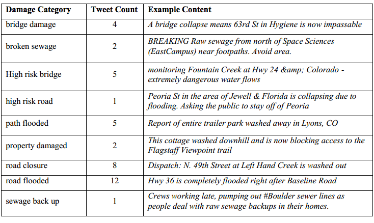
The study analyzed 212,672 unique tweets generated by 57,049 unique Twitter users. Of these tweets, 2,658 were geo-tagged. The researchers combed through these geo-tagged tweets for any information on infrastructure damage. A sample of these are included below (click to enlarge). Leysia et al. were particularly interested in geo-tagged tweets withpictures of infrastructure damage.
They overlaid these geo-tagged pictures on satellite and UAV/aerial imagery of the disaster-affected areas. The latter was captured by Falcon UAV. The satellite and aerial imagery provided the researchers with an easy way to distinguish between vegetation and water. “Most tweets appeared to fall primarily within the high flood hazard zones. Most bridges and roads that were located in the flood plains were expected to experience a high risk of damage, and the tweets and remote data confirmed this pattern.” According to Shideh Dashti, an assistant professor of civil, environmental and architectural engineering, and one of the co-authors, “we compared those tweets to the damage reported by engineering reconnaissance teams and they were well correlated.”
To this end, by making use of real-time reporting by those affected in a region, including their posting of visual data,” Leysia and team “show that tweets may be used to directly support engineering reconnaissance by helping to digitally survey a region and navigate optimal paths for direct observation.” In sum, the results of this study demonstrate “how tweets, particularly with postings of visual data and references to location, may be used to directly support geotechnical experts by helping to digitally survey the affected region and to navigate optimal paths through the physical space in preparation for direct observation.”
Since the vast majority of tweets are not geo-tagged, GPS coordinates for potentially important pictures in these tweets are not available. The authors thus recommend looking into using natural language processing (NLP) techniques to “expose hazard-specific and site-specific terms and phrases that the layperson uses to report damage in situ.” They also suggest that a “more elaborate campaign that instructs people how to report such damage via tweets […] may help get better reporting of damage across a region.”
These findings are an important contribution to the humanitarian computing space. For us at QCRI, this research suggests we may be on the right track with MicroMappers, a crowdsourcing (technically a microtasking) platform to filter and geo-tag social media content including pictures and videos. MicroMappers was piloted last year in response to Typhoon Haiyan. We’ve since been working on improving the platform and extending it to also analyze UAV/aerial imagery. We’ll be piloting this new feature in coming weeks. Ultimately, our aim is for MicroMappers to create near real-time Crisis Maps that provide an integrated display of relevant Tweets, pictures, videos and aerial imagery during disasters.
See also:
Using AIDR to Automatically Collect & Analyze Disaster Tweet [link]
Crisis Map of UAV Videos for Disaster Response [link]
Humanitarians in the Sky: Using UAVs for Disaster Response [link]
Digital Humanitarian Response: Why Moving from Crowdsourcing to Microtasking is Important [link]
The International Rescue Committee (IRC) recently sent me this article written by Alyoscia D’Onofrio (their Senior Director for Governance & Rights Programs) who kindlyinvited me to comment. So I’ll first summarize his key points and will then add my own commentary. As always, I very much welcome feedback from iRevolution readers.
Alyoscia is understandably concerned about some of the negative ways that UAVs could be perceived by crisis-affected communities, especially given the “increasingly blurred lines between aid and military actors over the last two decades.” While he calls OCHA’s recent Policy Brief on humanitarian UAVs a “useful summary of many issues that humanitarian agencies need to consider,” he directly questions the brief’s policy recommendation that UAVs be used in response to natural hazards rather than in conflict settings. The IRC’s Senior Director argues that the added value of UAVs is far more obvious “in fragile, crisis-affected settings” faced with “natural-hazard induced disasters.” Indeed, “Why would humanitarian actors need to deploy drones if there is a strong, responsive state?” asks Alyoscia.
The author doesn’t buy the policy brief’s “suggested approaches to disassociating humanitarian from military drone use in the policy brief,” like painting UAVs in bright colors. These suggestions “border on the silly” according to Alyoscia, who cites this book on conflict resolution and international intervention to argue that “people affected by crises have a hard time distinguishing among humanitarian actors or, more worryingly, between humanitarian and UN military actors,” even those these have different “colored cars, logos, flags, building signs, T-shirts, etc.” According to Alyoscia, “This draws attention to a really important point: While we may agonize over [the above issues], the real issue is about how the people we aim to serve, work with, move past and live near perceive us. Investing time (and money) in understanding our clients’ needs, wants and desires as well as broader social perceptions of our presence and actions, remains a critical imperative in humanitarian interventions.”
In conclusion, Alyoscia writes that “The potential for misunderstanding is extremely high and should be the focus of serious attention for any agency wanting to move forward in deploying this technology.”
My Commentary
Given Alyoscia’s strong emphasis on perception as “the real issue” and his deep concern about the very high probability for misunderstandings, I was surprised to see no reference in his article to community-centered approaches (even if only in one sentence, one hyperlink or one footnote). This explains my first response to his blog post:
Actually, I shared the Haiti example because it was not referenced in the Policy Brief. The UAV project was launched after the bulk of the report had already been written. (The Policy Brief does mention this grassroots UAV project carried out by SkyEye in the Philippines, however). One reason I emphasized the Haiti project was to demonstrate that community engagement is absolutely key in raising awareness about UAVs and managing perceptions. This lowers the risk of misunderstandings; almost entirely (?) if local communities fly their own UAVs and analyze the resulting imagery themselves, which is the main impetus behind the project in Port-au-Prince.
There’s no reason why the use of UAVs is incompatible with spending time & money to better understand community needs, wants and desires along with perceptions. The International Organization for Migration (IOM) makes this perfectly clear vis-a-vis their UAV projects (as documented in OCHA’s Policy Brief). As I’ve noted previously, the UAV is simply another tool in the tool box for community mapping projects—otherwise known as Public Participatory GIS (PPGIS). With that, let me turn to Alyoscia’s blog post.
Alyoscia opens with the following:
Let’s try a little word association game:
I say… “drone.”
You say… “humanitarian assistance.”
No?
The word drone brings to mind military uses for most of us. But so did satellites (think Sputnik) and aerial imagery (think Cuban Missile Crisis) during the Cold War. Today, however, when most of us think about satellite imagery, we think about Google Maps or Google Earth rather than Mutually-Assured-Destruction. Point is, perceptions are not static, they change as technologies spill over into the civilian sector and become more democratized.
OCHA’s Policy Brief discourages the use of UAVs in conflict zones, a point that the IRC’s Senior Director evidently questions. But the reason OCHA makes this recommendation is precisely because of the complex issues that Alyoscia later raises around perceptions and the blurring of aid and military actors. So I’m puzzled by this critique. I’m also not sure what to do with this rhetorical question: “Why would humanitarian actors need to deploy drones if there is a strong, responsive state?” Surely one could also ask: “Why would humanitarian actors need to deploy themselves, satellite imagery, mobile phones and [insert your favorite item here] if there is a strong, responsive state?”
In any event, the question overlooks the fact that UAVs are already proving to be useful—regardless of whether they’re used in strong or weak states. The Brief’s case studies demonstrate the added value that UAVs have already had in disaster preparedness preparedness, response and also recovery. More recent examples include these missions in the Balkans following the flooding earlier this summer and also these in China after the earthquake in Ludian last month. But Alyoscia’s reflections focus exclusively on the use of UAVs in conflict zones, which OCHA clearly describes as problematic. So there is no disagreement there. On a related note, this aerial video of Gaza taken by a Palestinian-based production company after the Israeli shelling of Al-Shejaiya may be of interest; the video has well over a quarter of a million views on YouTube. Alyoscia does not consider the role of local professional journalists in his reflections on humanitarian UAVs.
As for the UN’s “silly” suggestion on ways to disassociate humanitarian UAVs from military ones, it may help to quote directly from the original report to provide some context:
“The Unmanned Aerial Vehicle Systems Association in the UK has suggested that civilian UAVs be painted bright colors to distinguish them from military vehicles. Using this principle, medical deliveries across battle-lines in an urban environment could be cleared with parties to the conflict, and then carried out with a brightly-marked, low-flying UAV. However, it is unclear whether this strategy would work, and it is likely that UAVs in conflict settings would currentlypose more problems than they solve.”
The book that Alyoscia draws on to substantiate his concerns does not focus on responses to natural hazards but rather on interventions in conflict zones. This obviously doesn’t mean that Alyoscia’s genuine concerns about the use of UAVs in conflict settings aren’t warranted, they absolutely are. These same concerns (which I certainly share) have been raised before in a number of papers and articles. Furthermore, the challenge around the sharing of military intelligence with humanitarians predates the rise of UAVs. But arguing, as Alyoscia does, that UAVs offer comparatively little value when it comes to natural hazards is simply not supported by the empirical evidence; this evidence also contradicts the argument that strong states do not need UAVs.
So using these (problematic) arguments to suggest that UAVs would have more value in complex emergencies and then faulting OCHA for discouraging the use of UAVs in conflict zones is perhaps a tad unfair. And then focusing on all the problems associated with the use of UAVs in conflict zones (perceptions, security, blurred lines, etc.) to make a general point about the dangers of using UAVs (conflating conflict & non-conflict zones) doesn’t seem right either. Again, this does not imply that Alyoscia’s reflections are not important, they are and we need to discuss these challenges. This is one of the reasons I founded the Humanitarian UAV Network (UAViators), to engage in these important policy conversations and craft practical, legal & ethical solutions. We will be discussing these and other issues at the upcoming “Experts Meeting on Humanitarian UAVs” co-organized by OCHA & UAViators this November at UN Headquarters.
In the meantime, sincere thanks to both Alyoscia and the IRC for sharing these important reflections. (And kudos to the IRC for blogging!). I hope other groups will engage in these conversations and take the opportunity to sharepotential & actionablesolutions since the challenges have already been articulated. There also seems to be sufficient convergence on which of these problems represent the most important & pressing priorities. So lets start to shift the conversations on humanitarian UAVs to solutions-oriented discourse rather than repeating the well-known challenges.
See Also:
Humanitarian UAV Network: Strategy for 2014-2015 [link]
Common Misconceptions About Humanitarian UAVs [link]
Crisis Map of UAV Videos for Disaster Response [link]
Humanitarians in the Sky: Using UAVs for Disaster Response [link]
Google Already Developing UAV’s for Disaster Response [link]
WHO Using UAVs to Transport Medical Supplies [link]
TripAdvisor for International UAV/Drone Travel [link]
Aerial footage captured by a small civilian UAV/drone shows the scale of the devastation caused by Israeli bombardment during the recent conflict:
Media Town, a Palestinian-based production company, flew their DJI Phantom2 quadcopter (pictured below) with a GoPro Hero+3 camera over Gaza City’s eastern suburb of Al-Shejaiya just a few days ago. Al-Shejaiya saw some of the heaviest fighting during the conflict and faced the full force of Israel’s heaviest shelling in July. The footage is a short excerpt from a 40 minute aerial video captured in full high-definition quality. You can also compare aerial footage taken before the shelling with post-bombardment footage in this edited video.
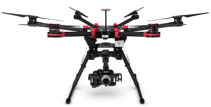
We will see a rapid increase in aerial footage of post-conflict and post-disaster areas as more local media companies around the world turn to UAVs to support their journalism work. Humanitarian organizations are also exploring the use of UAVs to accelerate their damage assessment efforts following major disasters. The UN Office for the Coordination of Humanitarian Affairs (OCHA), for example, recently published this Policy Brief on UAVs and is also experimenting with the DJI Phantom 2 pictured below.
My team & I at QCRI have thus launched this Crisis Map of Aerial Videos (which will soon include pictures) to collect disaster footage taken by UAVs across the globe. We have also developed a crowdsourcing platform called MicroMappers to make sense of aerial videos (and soon pictures). Eventually, we hope to combine this crowdsourced analysis of aerial imagery with automated methods. We also plan to integrate actionable content taken from aerial footage with social media reports from crisis areas.
See Also:
Crisis Map of UAV Videos for Disaster Response [link]
Official UN Policy Brief on Humanitarian UAVs [link]
Humanitarians in the Sky: Using UAVs for Disaster Response [link]
Humanitarian UAV Missions During Balkan Floods [link]
UAVs, Community Mapping & Disaster Risk Reduction in Haiti [link]
GoogleX is building and flying UAVs in the Australian outback. Codenamed Project Wing, Google’s super stealthy initiative was just announced to the public via The Atlanticin this exclusive article. The hybrid UAV delivers small packages by hovering in place (pictured above) and lowering it’s payloads using a thin line connected to the UAV itself. Once the package nears the ground, it detaches from the line which “ascends back up the vehicle, locking into place beneath the nose.” According to the BBC, “Google said that its long-term goal was to develop drones that could be used for disaster relief by delivering aid to isolated areas. They could be used after earthquakes, floods, or extreme weather events, the company suggested, to take small items such as medicines or batteries to people in areas that conventional vehicles cannot reach.”
“Even just a few of these, being able to shuttle nearly continuously could service a very large number of people in an emergency situation,” according to Google. Project Wing was initially focused on “delivering defibrillators to help people who have had heart attacks. The key factor in the success of using a defibrillator is how quickly it is deployed, so saving a few minutes of transit time could make for a lifesaving application,” writes The Atlantic. “When you have a tool like this you can really allow the operators of those emergency services to add an entirely new dimension to the set of tools and solutions that they can think of,” says Google’s new lead for Project Wing.
The multi-billion dollar companies Google and Amazon aren’t alone in exploring the use of UAVs for payload delivery, however. As I wrote earlier this week, both the World Health Organization (WHO) and Médecins Sans Frontières (MSF) are experimenting with UAVs as are colleagues at UNICEF. And as a pivotal United Nations Report on UAVs notes, the Gates Foundation and MIT have been developing small UAVs that can be deployed “via SMS to swiftly transport small quantities of vaccines to clinics or health workers in isolated locations when roads were out, or the quantities don’t justify a car or truck delivery.”
The advanced research and development (R&D) carried by Google and Amazon will no doubt benefit WHO, MSF, UNICEF and others in the humanitarian UAV space—particularly if they develop their programs in a way that allows other groups to tap into their infrastructure. As one UAV expert notes, “The significance of what Google does, to me, is less in the vehicles they use here and now.” Perhaps far more important is Google (and Amazon) implementing the infrastructure that’s needed to facilitate innovation in the UAV space. The detect-and -avoid systems “will need to be certified,” for example, “and Google could help governments figure out how to do so.”
These are all exciting and promising developments for the Humanitarian UAV Network (UAViators), which promotes the safe and responsible use of UAVs in humanitarian settings. The Network’s Advisory Board includes representatives from the Red Cross as well as the United Nations in addition to key UAV experts. UAViators (pronounced You-Aviators) is co-organizing the first ever “Experts Meeting on Humanitarian UAVs” this fall at UN Headquarters in New York. On the agenda for this meeting is the use of UAVs for imagery captureand beyond, that is, for payload delivery. So I hope my colleagues at Google Crisis Response will attend the meeting so we can discuss how humanitarian organizations might leverage Google’s UAVs in the near future.
My forthcoming bookDigital Humanitarians (2015) explores the use of UAVs for disaster response as well as the roles that satellite imagery, social media and cell phone data are playing in relief efforts today.
See Also:
Humanitarians in the Sky: Using UAVs for Disaster Response [link]
WHO Using UAVs to Transport Medical Supplies [link]
Humanitarian UAV Missions During Balkan Floods [link]
Humanitarian UAVs Fly in China After Earthquake [link]
Crisis Map of UAV Videos for Disaster Response [link]
TripAdvisor for International UAV/Drone Travel [link]
UAVs, Community Mapping & Disaster Risk Reduction in Haiti [link]
The World Health Organization (WHO) is experimenting with Matternet’s new quadcopters (one of which is pictured below) to transport medical supplies to remote regions in Bhutan. The country lies in the Himalayas, which makes access to public health particularly challenging for rural communities. Reaching these remote mountain populations in a timely and affordable way is key. This explains why WHO is looking into UAVs.
Matternet is “aiming to build a network of low-cost quadcopters to connect the country’s main hospitals with rural communities.” The team “uses small quad- copters that can carry loads of about four pounds across 20 km at a time, to and from pre-designated landing stations. The company is able to track these flights in real-time, and aims to eventually deploy fully-automated landing stations that replace drone batteries, giving them extended range and flight time. The drones it uses typically cost between $2,000-5,000.”
WHO is not the only international humanitarian organization exploring the use of UAVs for the transportation of small payloads. Colleagues at UNICEF and Médecins Sans Frontières (MSF) are actively exploring this use-case as well with the latter in early pilot stages with Matternet in Papua New Guinea.
UAVs can also be used in other ways to support public health projects. Take my UAV colleagues in the Philippines who are collaborating with the United Nations Development Program (UNDP) on a food security problem with obvious linkages to public health. Typhoon Haiyan uprooted millions of coconut trees when it barreled through the country. Many of these trees have since been rotting, which is now leading to a Rhinocerous Beetle infestation that can wipe out the entire coconut industry—a very important source of livelihood for many in the country. Meanwhile, other colleagues in Pakistan are looking into using UAVs “to identify and exterminate dengue larvae” as part of an existing intervention that uses smart phones to promote mosquito mitigation efforts.
See Also:
Humanitarian UAV Network: Strategy for 2014-2015 [link]
Humanitarians in the Sky: Using UAVs for Disaster Response [link]
Crisis Map of UAV Videos for Disaster Response [link]
Humanitarian UAV Missions During Balkan Floods [link]
“TripAdvisor” for International UAV/Drone Travel [link]
UAVs, Community Mapping & Disaster Risk Reduction in Haiti [link]
The United Nations Office for the Coordination of Humanitarian Affairs (OCHA) just published a pivotal policy document (PDF) on the use of civilian UAVs in humanitarian settings. Key excerpts from this 20-page & must-read publication are highlighted below.
UAVs are increasingly performing civilian tasks as the technology becomes more common. In fact, 57 countries and 270 companies were manufacturing UAVs in 2013.
Humanitarian organizations have started to use UAVs, including in Haiti and the Philippines, for data collection and information tasks that include real time information and situation monitoring, public information and advocacy, search and rescue, and mapping.
Use of UAVs raises serious practical & ethical issues that humanitarian organizations must address through transparency, community engagement, and guidelines for privacy & data security.
To tap into the growing interest in UAVs, particularly in technical communities, humanitarian organizations should engage in networks that promote good practices and guidance, and that can serve as a source of surge capacity. [Like the Humanitarian UAV Network].
Due to their affordability, ease of transport, and regulatory concerns UAVs used in humanitarian response are likely to be small or micro-UAVs of up to a few kilograms, while larger systems will remain the province of military and civil defense actors.
Interest is building in the use of UAVs to assist in search and rescue, particularly when equipped with infrared, or other specialty cameras. For example, the European Union is funding ICARUS, a research project to develop unmanned search and rescue tools to assist human teams. [Picture above is of UAV used by ICARUS].
The analysis of data from these devices ranges from straight-forward to quite technically complex. Analytical support from crowdsourcing platforms, such as Humanitarian Open Street Map’s Tasking Server or QCRI’s MicroMappers, can speed up analysis of technical data, including building damage or population estimates.
More research is needed on integrating aerial observation and data collection into needs and damage assessments, search and rescue, and other humanitarian functions.
The biggest challenges to expanding the use of UAVs are legal and regulatory. […]. Most countries where humanitarians are working do not yet have legal frameworks, meaning that use of UAVs will probably need to be cleared on an ad hoc basis with local authorities. A particular issue is interference with traditional air traffic […].
Any use of UAVs by humanitarian actors […] requires clear policies on what information they will share or make public, how long they will store it and how they will secure it. […]. For humanitarians operating UAVs, transparency and engagement will likely be critical for success. Ideally, communities or local authorities would be informed of the timing of flights, the purpose of the mission and the type of data being collected, with the aim of having some kind of informed consent, whether formal or informal.
Although UAVs are getting safer, due to parachutes, collision avoidance systems and fail-safe mechanisms, humanitarians must think seriously about liability insurance and its cost implications, particularly for mechanical failure. Due in part to these safety concerns, ultra-light UAVs, such as those under a kilogram, will tend to be more lightly regulated and therefore easier to import & operate.
More non-profit or volunteer groups are also emerging, such as the Humanitarian UAV Network, a global volunteer network of operators working for safe operations & standards for humanitarian uses of UAVs.
The pressure for humanitarians to adopt this technology [UAVs], or to provide principled justifications for why they do not, will only increase. […]. Until UAVs are much more established in general civilian use, the risks of humanitarians using UAVs in conflict settings are greater than the benefits. The focus therefore should be developing best practices and guidelines for their use in natural disasters, slow-onset emergencies and early recovery.
In conclusion, the UN brief offers several policy considerations:
Focus on using UAVs in natural disasters and avoid use in conflicts.
Develop a supportive legal and regulatory framework.
Prioritize transparency and community engagement.
Ensure principled partnerships.
Strengthen the evidence base.
Update response mechanisms […] to incorporate potential use of UAVs and to support pilot projects.
Support networks and communities of practice. […]. Humanitarian organizations should engage in initiatives like the Humanitarian UAV Network, that aim to develop and promote good practices and guidance and that can serve as advisors and provide surge capacity.
The Humanitarian UAV Network (UAViators) is actively engaged in pursuing these (and other) action items. The Network promotes the safe and responsible use of UAVs in non-conflict settings and is engaged in policy conversations vis-a-vis ethical, legal & regulatory frameworks for the use of UAVs in humanitarian settings. The Network is also bringing UAV experts together with seasoned humanitarian professionals to explore how best to update formal response mechanisms. In addition, UAViators emphasizes the importance of community participation. Finally, the Network carries out research to build a more rigorous evidence base so as to better document the opportunities and challenges of UAVs in humanitarian settings.
See Also:
Humanitarians in the Sky: Using UAVs for Disaster Response [link]
Live Crisis Map of UAV Videos for Disaster Response [link]
Humanitarian UAV Missions During Balkan Floods [link]
UAVs, Community Mapping & Disaster Risk Reduction in Haiti [link]
“TripAdvisor” for International UAV/Drone Travel [link]
How UAVs are Making a Difference in Disaster Response [link]
Humanitarians Using UAVs for Post Disaster Recovery [link]
A 6.1 magnitude earthquake struck Ludian County in Yunnan, China earlier this month. Some 600 people lost their lives; over 2,400 were injured and another 200,000 were forced to relocate. In terms of infrastructure damage, about 30,000 buildings were damaged and more than 12,000 homes collapsed. To rapidly search for survivors and assess this damage, responders in China turned to DJI’s office in Hong Kong. DJI is one of leading manufacturers of commercial UAVs in the world.
DJI’s team of pilots worked directly with the China Association for Disaster and Emergency Response Medicine (CADERM). According to DJI, “This was the first time [the country] used [UAVs] in its relief efforts and as a result many of the cooperating agencies and bodies working on site have approached us for training / using UAS technology in the future […].” DJI flew two types of quadcopters, the DJI S900 and DJI Phantom 2 Vision+ pictured below (respectively):
As mentioned here, The DJI Phantom 2 is the same one that the UN Office for the Coordination of Humanitarian Affairs (OCHA) is experimenting with:
Given the dense rubble and vegetation in the disaster affected region of Ludian County in China, ground surveys were particularly challenging to carry out. So UAVs provided disaster responders with an unimpeded bird’s eye view of the damage, helping them prioritize their search and rescue efforts. DJI reports that the UAVs “were able to relay images back to rescue workers, who used them to determine which roads needed to be cleared first and which areas of the rubble to search for possible survivors. […].”
The video above shows some striking aerial footage of the disaster damage. This is the not first time that UAVs have been used for search and rescue or road clearance operations. Transporting urgent supplies to disaster areas requires that roads be cleared as quickly as possible, which is why UAVs were used for this and other purposes after Typhoon Haiyan in the Philippines. In Ludian, “Aerial images captured by the team were [also] used by workers in the epicenter area […] where most of the traditional buildings in the area collapsed.”
DJI was not the only group to fly UAVs in response to the quake in Yunnan. The Chinese government itself deployed UAVs (days before DJI). As the Associated Pressreported several weeks ago already, “A novel part of the Yunnan response was the use of drones to map and monitor a quake-formed lake that threatened to flood areas downstream. China has rapidly developed drone use in recent years, and they helped save time and money while providing highly reliable data, said Xu Xiaokun, an engineer with the army reserves.”
Working with UAV manufacturers directly may prove to be the preferred route for humanitarian organizations requiring access to aerial imagery following major disasters. At the same time, having the capacity and skills in-house to rapidly deploy these UAVs affords several advantages over the partnership model. So combining in-house capacity with a partnership model may ultimately be the way to go but this will depend heavily on the individual mandates and needs of humanitarian organizations.
See Also:
Humanitarians in the Sky: Using UAVs for Disaster Response [link]
Live Crisis Map of UAV Videos for Disaster Response [link]
Humanitarian UAV Missions During Balkan Floods [link]
UAVs, Community Mapping & Disaster Risk Reduction in Haiti [link]
“TripAdvisor” for International UAV/Drone Travel [link]
The Humanitarian UAV Network (UAViators) promotes the safe and responsible use of UAVs in humanitarian settings. As noted in the network’s Code of Conduct, knowing national and local UAV laws is an important aspect flying UAVs in a safe and responsible manner. To this end, we have just launched a “TripAdvisor” for UAV/drone travel in the form of this wiki:
The Wiki is a country directory for UAV pilots to share their travel and flying experiences around the world, such as going through customs and how to obtain permits for flying, for example. The Wiki also includes information on national and local laws when available. We would like this to be a community-driven effort, which is why we decided to use a Wiki. In sum, we’d like to crowdsource the content for this Wiki. Our mission is make it the most popular and useful resource on the web for UAV pilots. You can help by adding your experience and knowledge directly to the Wiki. Thank you! And many thanks to my Research Team for all their hard work on the Wiki.
See Also:
Humanitarian UAV Network: Strategy for 2014-2015 [link]
Humanitarians in the Sky: Using UAVs for Disaster Response [link]
Crisis Map of UAV Videos for Disaster Response [link]
Check-List for Flying UAVs in Humanitarian Settings [link]
Humanitarian UAV Missions During Balkan Floods [link]
UAVs, Community Mapping & Disaster Risk Reduction in Haiti [link]
My team & I at the Humanitarian UAV Network (UAViators) have just completed the first phase of our evaluation and welcome feedback on the results. We have reviewed over 150 UAV models along with camera technologies, payload units as well as image processing and analysis software. Each of these items have been reviewed within the context of humanitarian applications and with humanitarian practitioners in mind as end-users.
The results of the evaluation are available herein the form of an open and editable Google spreadsheet. We are actively looking for feedback and very much welcome additional entries. So feel free to review & add more UAVs and related technologies directly to the spreadsheet. Our second phase will involve the scoring/weighing of the results to identity the UAVs, cameras and software that may be the best fit for humanitarian organizations.
In the meantime, big thanks to my research assistants who carried out all the research for this review.
See Also:
Humanitarian UAV Network: Strategy for 2014-2015 [link]
Humanitarians in the Sky: Using UAVs for Disaster Response [link]
Humanitarian UAV Missions During Balkan Floods [link]
UAVs, Community Mapping & Disaster Risk Reduction in Haiti [link]
Crisis Map of UAV Videos for Disaster Response [link]
Check-List for Flying UAVs in Humanitarian Settings [link]
I’ve been advocating for the development of a “Match.com” for disaster response since early 2010. Such a platform would serve to quickly match hyperlocal needs with relevant resources available at the local and national level, thus facilitating and accelerating self-organization following major disasters. Why advocate for a platform modeled after an online dating website? Because self-organized mutual-aid is an important driver of community resilience.
Obviously, self-organization is not dependent on digital technology. The word Rynda, for example, is an old Russian word for a “village bell” which was used by local communities to self-organize during emergencies. Interestingly, Rynda became a popular meme on social media during fires in 2010. As my colleague Gregory Asmolovnotes in his brilliant new study, a Russian blogger at the time of the fires “posted an emotional open letter to Prime Minister Putin, describing the lack of action by local authorities and emergency services.” In effect, the blogger demanded a “return to an old tradition of self-organization in local communities,” subsequently exclaiming “bring back the Rynda!” This demand grew into a popular meme symbolizing the catastrophic failure of the formal system’s response to the massive fires.
At the time, my colleagues Gregory, Alexey Sidorenko & Glafira Parinos launched the Help Map above in an effort to facilitate self-organization and mutual aid. But as Gregory notes in his new study, “The more people were willing to help, the more difficult it was to coordinate the assistance and to match resources with needs.” Moreover, the Help Map continued to receive reports on needs and offers-of-help after the fires had subsided. To be sure, reports of flooding soon found their way to the map, for example. Gregory, Alexey, Glarifa and team thus launched “Virtual Rynda: The Help Atlas” to facilitate self-help in response to a variety of situations beyond sudden-onset crises.
“We believed that in order to develop the capacity and resilience to respond to crisis situations we would have to develop the potential for mutual aid in everyday life. This would rely on an idea that emergency and everyday-life situations were interrelated. While people’s motivation to help one another is lower during non-emergency situations, if you facilitate mutual aid in everyday life and allow people to acquire skills in using Internet-based technologies to help one another or in asking for assistance, this will help to create an improved capacity to fulfill the potential of mutual aid the next time a disaster happens. […] The idea was that ICTs could expand the range within which the tolling of the emergency bell could be heard. Everyone could ‘ring’ the ‘Virtual Rynda’ when they needed help, and communication networks would magnify the sound until it reached those who could come and help.”
In order to accelerate and scale the matching of needs & resources, Gregory and team (pictured below) sought to develop a matchmaking algorithm. Rynda would ask users to specify what the need was, where (geographically) the need was located and when (time-wise) the need was requested. “On the basis of this data, computer-based algorithms & human moderators could match offers with requests and optimize the process of resource allocation.” Rynda also included personal profiles, enabling volunteers “to develop an online reputation and increase trust between those needing help and those who could offer assistance. Every volunteer profile included not only personal information, but also a history of the individual’s previous activities within the platform.” To this end, in addition to “Help Requests” & “Help Offers,” Rynda also included an entry for “Help Provided” to close the feedback loop.
As Gregory acknowledges, the results were mixed but certainly interesting and insightful. “Most of the messages [posted to the Rynda platform dealt] with requests for various types of social help, like clothing and medical equipment for children, homes for orphans, people with limited capabilities, or families in need. […]. Some requests from environmental NGOs were related to the mobilization of volunteers to fight against deforestation or to fight wildfires. […]. In another case, a volunteer who responded to a request on the platform helped to transport resources to a family with many children living far from a big city. […]. Many requests concern[ed] children or disabled people. In one case, Rynda found a volunteer who helped a young woman leave her flat for walks, something she could not do alone. In some cases, the platform helped to provide medicine.” In any event, an analysis of the needs posted to Rynda suggests that “the most needed resource is not the thing itself, but the capacity to take it to the person who needs it. Transportation becomes a crucial resource, especially in a country as big as Russia.”
Alas, “Despite the efforts to create a tool that would automatically match a request with a potential help provider, the capacity of the algorithm to optimize the allocation of resources was very limited.” To this end, like the Help Map initiative, digital volunteers who served as social moderators remained pivotal to the Virtual Ryndal platform. As Alexey notes, “We’ve never even got to the point of the discussion of more complex models of matching.” Perhaps Rynda should have included more structured categories to enable more automated-matching since the volunteer match-makers are simply not scalable. “Despite the intention that the ‘matchmaking’ algorithm would support the efficient allocation of resources between those in need and those who could help, the success of the ‘matchmaking’ depended on the work of the moderators, whose resources were limited. As a result, a gap emerged between the broad issues that the project could address and the limited resources of volunteers.”
To this end, Gregory readily admits that “the initial definition of the project as a general mutual aid platform may have been too broad and unspecific.” I agree with this diagnostic. Take the online dating platform Match.com for example. Match.com’s sole focus is online dating; Airbnb’s sole purpose is to match those looking for a place to stay with those offering their places; Uber’s sole purpose is matching those who need to get somewhere with a local car service. To this end, matching platform for mutual-aid may indeed been too broad—at least to begin with. Amazon began with books, but later diversified.
In any case, as Gregory rightly notes, “The relatively limited success of Rynda didn’t mean the failure of the idea of mutual aid. What […] Rynda demonstrates is the variety of challenges encountered along the way of the project’s implementation.” To be sure, “Every society or community has an inherent potential mutual aid structure that can be strengthened and empowered. This is more visible in emergency situations; however, major mutual aid capacity building is needed in everyday, non-emergency situations.” Thanks to Gregory and team, future digital matchmakers can draw on the above insights and Rynda’s open source code when designing their own mutual-aid and self-help platforms.
For me, one of the key take-aways is the need for a scalable matching platform. Match.com would not be possible if the matching were done primarily manually. Nor would Match.com work as well if the company sought to match interests beyond the romantic domain. So a future Match.com for mutual-aid would need to include automated matching and begin with a very specific matching domain.
See also:
Using Waze, Uber, AirBnB, SeeClickFix for Disaster Response [link]
MatchApp: Next Generation Disaster Response App? [link]
A Marketplace for Crowdsourcing Crisis Response [link]
I thrive when working across disciplines, building diverse cross-cutting coalitions to create, translate and apply innovative strategies driven by shared values. This has enabled the 20+ organizations I’ve worked with, and those I’ve led, to accelerate meaningful and inclusive social impact.
Which is why I've been called a social entrepreneur and a translational leader by successful innovators. President Clinton once called me a digital pioneer, while recent colleagues describe me as kind, dedicated, values-driven, authentic, creative, ethical, and impactful.